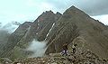
Slioch

Last updated

Slioch
Scottish Gaelic: Sleaghach
Slioch from Loch Maree.jpg
Slioch seen from the shores of Loch Maree.
Highest point
Elevation 981 m (3,219 ft) [1]
Prominence 626 m (2,054 ft)
Parent peak Sgurr Mor
Listing Munro, Marilyn
Naming
English translationthe spear
Language of name Gaelic
PronunciationEnglish: /ˈslɒx/
Scottish Gaelic: [ˈʃlɤ.əx]
Geography
Location Wester Ross, Scotland
OS grid NH004688
Topo map OS Landranger 19, OS Explorers 433, 435

Slioch (Scottish Gaelic : Sleaghach) is a mountain in the Scottish Highlands situated in Wester Ross, eight kilometres north of the village of Kinlochewe. Slioch reaches an elevation of 981 metres (3,219 feet) and towers above the southeastern end of Loch Maree to give one of the best known and most photographed sights (from the A832 road) in the Highlands. VisitScotland, the Scottish national tourist agency, has used video footage of Slioch in its television advertisements.

Contents

The mountain is composed of Torridonian sandstone on a base of Lewisian Gneiss and has steep crags on three sides and allows easy access for the walker only from the south east where the large open corrie of Coire na Sleaghaich has two ridges on its flanks which the walker can use. The mountain's name comes from the Gaelic word "sleagh" and means "the spear" and this only becomes obvious when Slioch is viewed from Lochan Fada to the northeast, from here the subsidiary top of Sgùrr an Tuill Bhàin (The Peak of the White Hollow) (933 metres) dominates as a slender peak and gives the mountain its name. Feral goats are often seen on the mountain.

Ascent

Slioch is climbed almost exclusively from Incheril, one kilometre east of Kinlochewe. Starting from here involves a flat five kilometre approach walk northwest along the banks of the Kinlochewe River and Loch Maree before any climbing begins. An impressive 100-metre-high (330 ft) waterfall is passed as it comes down off Beinn a’ Mhuinidh to join the river. When the foot of Gleann Bianasdail is reached the climbing begins: it is a one kilometre walk up the glen to a path that goes left and heads for Coire na Sleaghaich and then up the south east ridge of Slioch passing two small lochans, known to many as the 'twin lochans', to reach the summit of the mountain. The return journey can be varied by taking in the subsidiary top of Sgurr an Tuill Bhain and then descending south into the corrie to join the uphill route.

The summit has twin pinnacles: the southern top has a trig point with a height of 980 metres whilst the northern top is situated on the edge of the cliffs and is a finer viewpoint. In recent years it has been elevated to a height of 981 metres by the Ordnance Survey making it the highest point on the mountain. Slioch's isolation from other mountains makes the view from the summit extensive; it takes in the wilderness of the Fisherfield Forest to the north with its five Munros. The Torridon mountains and Loch Maree are also well seen.

Slioch is unusual in being bounded on three sides by waters flowing southeast (Lochan Fada), then southwest (Gleann Bianasdail) and finally northwest (Loch Maree). Ordnance Survey maps show Lochan Fada as having two outlets at its south-east end, the second being via Gleann na Muice to Kinlochewe and Loch Maree. Google Earth however shows no watercourse between the two ribbon lochans at the head of Allt Gleann na Muice, confirmed by its satellite elevation data, and by Bartholomew's Map [2]

The Fisherfield Munros from Slioch summit. Fisherfield Munro from Slioch summit.jpg
The Fisherfield Munros from Slioch summit.

Footnotes

  1. "walkhighlands Siloch". walkhighlands.co.uk. 2014. Retrieved 26 February 2014.
  2. National Library of Scotland, Bartholomew Survey Atlas, 1912

Related Research Articles

<span class="mw-page-title-main">Beinn Alligin</span> Mountain in Scotland

Beinn Alligin is one of the classic mountains of the Torridon region of Scotland, lying to the north of Loch Torridon, in the Highlands. The name Beinn Alligin is from the Scottish Gaelic, meaning Jewelled Hill. The mountain has two peaks of Munro status: Tom na Gruagaich to the south, and Sgùrr Mhòr at 986 metres (3,235 ft) to the north.

<span class="mw-page-title-main">Beinn Eighe</span> Mountain massif in the Scottish Highlands

Beinn Eighe is a mountain massif in the Torridon area of Wester Ross in the Northwest Highlands of Scotland. Lying south of Loch Maree, it forms a long ridge with many spurs and summits, two of which are classified as Munros: Ruadh-stac Mòr at 1,010 m (3,314 ft) and Spidean Coire nan Clach at 993 m (3,258 ft). Unlike most other hills in the area it has a cap of Cambrian basal quartzite which gives the peaks of Beinn Eighe a distinctive light colour. Its complex topography has made it popular with both hillwalkers and climbers and the national nature reserve on its northern side makes it an accessible mountain for all visitors.

<span class="mw-page-title-main">Sgùrr Choinnich</span> Mountain in Scotland

Sgùrr Choinnich is a mountain with a height of 999 metres (3,278 ft) in the Northwest Highlands of Scotland. Classed as a Munro, it is in the Achnashellach Forest area between Glen Carron and Loch Monar. It has mostly steep, grassy slopes, with a narrow summit ridge that runs east–west. There are crags on the northern side of this ridge, looking down into the corrie of Coire Choinnich.

<span class="mw-page-title-main">Sgorr Ruadh</span> Mountain in Scotland

Sgorr Ruadh is a mountain between Strath Carron and Glen Torridon in Wester Ross in the Northwest Highlands of Scotland. It is located in Coire Lair near Achnashellach along with two other mountains, Beinn Liath Mhòr and Fuar Tholl, and is often climbed together with one or both of these other mountains.

<span class="mw-page-title-main">Beinn Damh</span> Mountain in Scotland

Beinn Damh is a Scottish mountain situated in the wild mountainous area between Upper Loch Torridon and Glen Carron, 25 kilometres north northeast of Kyle of Lochalsh. Beinn Damh is classed as a Corbett reaching a height of 903 metres (2,962 feet) failing to qualify as a Munro by eleven metres, despite this it is a fine mountain with a four-kilometre-long undulating summit ridge with three tops, it has steep slopes and crags with its eastern face being especially dramatic with huge buttresses and cliffs. The mountain has the conspicuous “Stirrup Mark” just to the south west of the summit, this is a semi circular area of white quartzite surrounded by grey rock which stands out when the mountain is viewed from the south west. The mountain's translated name of “Hill of the Stag” is apt because it stands in the middle of the Ben Damh deer estate.

<span class="mw-page-title-main">Mam Sodhail</span> Mountain in Scotland

Mam Sodhail, or Màm Sabhail in Gaelic, sometimes anglicised "Mam Soul", is a mountain with a height of 1,181 metres (3,875 ft) in the Northwest Highlands of Scotland. Classed as a Munro, it is beside Carn Eige in the secluded country on the northern side of Glen Affric, some 30 kilometres east of Kyle of Lochalsh.

<span class="mw-page-title-main">Sgùrr na Lapaich</span> Mountain in Scotland

Sgurr na Lapaich is a mountain in the Northwest Highlands of Scotland, situated north of Loch Mullardoch in the high ground that separates Glen Cannich and Glen Strathfarrar. The mountain reaches a height of 1,150 metres, and is the fourth-highest mountain north of the Great Glen. There is no higher ground to the north of it in Great Britain.

<span class="mw-page-title-main">Sgùrr Fhuaran</span> Mountain in Scotland

Sgùrr Fhuaran is a Scottish mountain that is situated on the northern side of Glen Shiel, 23 kilometres (14 mi) east south east of Kyle of Lochalsh.

<span class="mw-page-title-main">Sgùrr nan Ceannaichean</span> Mountain in Scotland

Sgùrr nan Ceannaichean is a Scottish mountain situated 13 kilometres southwest of the village of Achnasheen on the southern side of Glen Carron within the Glencarron and Glenuig Forest in the Ross and Cromarty district of the Highland council area.

<span class="mw-page-title-main">Aonach Meadhoin</span> Mountain in Scotland

Aonach Meadhoin is a Munro mountain situated in the Kintail region of Scotland. It stands on the northern side of Glen Shiel some 31 kilometres south east of Kyle of Lochalsh.

<span class="mw-page-title-main">Sgùrr a' Bhealaich Dheirg</span>

Sgùrr a' Bhealaich Dheirg is a mountain in Kintail on the northern side of Glen Shiel in the Scottish Highlands. With a height of 1,036 metres (3,399 ft), it is classed as a Munro. It is the highest of three Munros known as the "Brothers of Kintail" in contrast to the Five Sisters of Kintail which lie just to the west.

<span class="mw-page-title-main">Beinn Dubhchraig</span> Mountain in Scotland

Beinn Dubhchraig is a mountain in the Scottish Highlands, west of Crianlarich in the northern part of Loch Lomond and the Trossachs National Park. It is a Munro with a height of 978 metres (3,209 ft). It is overshadowed by its neighbour Ben Lui, although it is well seen from the main A82 road. Its name means "mountain of the black rock", referring to the steep and rocky face on the southwest slopes above Loch Oss, which offer scrambling routes to the summit.

<span class="mw-page-title-main">Gairich</span>

Gairich, sometimes Sgurr Gairoch, is a mountain in Lochaber in the Northwest Highlands of Scotland. It is on the southern side of Loch Quoich, with Glen Garry to the east and Glen Kingie to the south, 25 kilometres north-northwest of Fort William.

<span class="mw-page-title-main">Beinn Achaladair</span>

Beinn Achaladair is a Scottish mountain situated six kilometres north east of the hamlet of Bridge of Orchy. The mountain stands on the border of the Perth and Kinross and Argyll and Bute council areas.

<span class="mw-page-title-main">Meall na Teanga</span>

Meall na Teanga is a Scottish mountain located in the Highland council area, 11 km (7 mi) north of Spean Bridge.

<span class="mw-page-title-main">An Riabhachan</span> Mountain in Scotland

An Riabhachan is a Scottish mountain in the Skye and Lochalsh district of the Highland council area. It is situated 35 kilometres east of Kyle of Lochalsh standing in an isolated position at the western end of Loch Mullardoch, ten kilometres from any public road.

<span class="mw-page-title-main">Càrn nan Gobhar (Mullardoch)</span> Mountain in Highland, Scotland, UK

Càrn nan Gobhar is a mountain rising to 993 metres (3,258 ft) in the Northwest Highlands of Scotland. It stands on the northern side of Loch Mullardoch in the upper part of Glen Cannich, in a remote group of four Munros informally known as "The Mullardochs" which form the high ground between Loch Mullardoch and Loch Monar.

<span class="mw-page-title-main">Sgùrr nan Clach Geala</span>

Sgùrr nan Clach Geala is a mountain in Wester Ross in the Northwest Highlands of Scotland, south of Ullapool. With a height of 1,093 metres (3,586 ft), it is one of ten Munros in the group of hills known as the Fannichs.

<span class="mw-page-title-main">Maoile Lunndaidh</span> Munro mountain in Scotland

Maoile Lunndaidh or Maoil Lunndaidh is a Scottish mountain situated 13 km south of Achnasheen in the Ross and Cromarty district of the Highland council area. It is part of the high ground between Loch Monar and Gleann Fhiodhaig.

<span class="mw-page-title-main">Seana Bhràigh</span>

Seana Bhràigh is a mountain east of Ullapool, in the Highlands of Scotland.

References

57°39′53″N5°20′53″W / 57.66469°N 5.34796°W / 57.66469; -5.34796