
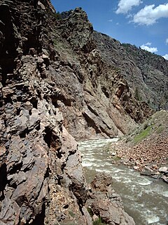
The Crystal River is a tributary of the Roaring Fork River, approximately 40 mi (64 km) long, in western Colorado in the United States. It drains a glacial valley, called the Coal Basin, south of Carbondale which was historically known as a center of coal mining in southwestern Colorado. It rises in northern Gunnison County in the Elk Mountains on the north side of Schofield Pass, passing through the ghost town of Crystal City, still inhabited by a few summer residents. It then flows north past Marble, then into Pitkin County past Redstone. It joins the Roaring Fork below Carbondale. State Highway 133 follows the river along much of its route north of Marble.

The Uncompahgre River is a tributary of the Gunnison River, approximately 75 mi (121 km) long, in southwestern Colorado in the United States. Lake Como at 12,215 ft (3723m) in northern San Juan County, in the Uncompahgre National Forest in the northwestern San Juan Mountains is the headwaters of the river. It flows northwest past Ouray, Ridgway, Montrose, and Olathe and joins the Gunnison at Confluence Park in Delta.

The North Fork Gunnison River is a tributary of the Gunnison River, 33.5 miles (53.9 km) long, in southwestern Colorado in the United States. It drains part of the southwestern flank of the Elk Mountains northeast of Delta.

The Grand Valley is an extended populated valley, approximately 30 miles (48 km) long and 5 miles (8 km) wide, located along the Colorado River in Mesa County, Colorado and Grand County, Utah in the United States. The valley contains the city of Grand Junction, as well as other smaller communities such as Fruita, and Palisade. The valley is noted as a major fruit-growing region, with a large number of orchards. It takes its name from the "Grand River", the historical name of the Colorado River upstream from its confluence with the Green River that was used by locals in the late 19th and early 20th century. The valley is the most densely populated area on the Colorado Western Slope, with Grand Junction serving as an unofficial capital of the region, as a counterpoint to Denver on the eastern slope of the Rocky Mountains in the Colorado Front Range. Interstate 70 and U.S. Highway 6 run through the valley from west-to-east. The Grand Valley is part of the larger Colorado Plateau desert lands.

Curecanti National Recreation Area is a National Park Service unit located on the Gunnison River in western Colorado. Established in 1965, Curecanti is responsible for developing and managing recreational facilities on three reservoirs, Blue Mesa Reservoir, Morrow Point Reservoir and Crystal Reservoir, constructed on the upper Gunnison River in the 1960s by the U.S. Bureau of Reclamation to better utilize the vital waters of the Colorado River and its major tributaries. A popular destination for boating and fishing, Curecanti offers visitors two marinas, traditional and group campgrounds, hiking trails, boat launches, and boat-in campsites. The state's premiere lake trout and Kokanee salmon fisheries, Curecanti is a popular destination for boating and fishing, and is also a popular area for ice-fishing in the winter months.

Blue Mesa Reservoir is an artificial reservoir located on the upper reaches of the Gunnison River in Gunnison County, Colorado. The largest lake located entirely within the state, Blue Mesa Reservoir was created by the construction of Blue Mesa Dam, a 390-foot tall earthen fill dam constructed on the Gunnison by the U.S. Bureau of Reclamation in 1966 for the generation of hydroelectric power. Managed as part of the Curecanti National Recreation Area, a unit of the National Park Service, Blue Mesa Reservoir is the largest lake trout and Kokanee salmon fishery in Colorado.
The Cimarron River is a 22.0-mile-long (35.4 km) tributary that joins the Gunnison River in Curecanti National Recreation Area near Cimarron, Colorado. The river's source is the confluence of two forks near Silver Jack Reservoir in the Uncompahgre National Forest.

Lake Fork Gunnison River or Lake Fork is a 64.7-mile-long (104.1 km) tributary of the Gunnison River in Colorado. The river's source is Sloan Lake near Handies Peak in the San Juan Mountains of Hinsdale County. Lake Fork flows through Lake San Cristobal and Lake City before a confluence with the Gunnison River in Blue Mesa Reservoir.
Middle Fork Cimarron River is a 10.3-mile-long (16.6 km) tributary of the Cimarron River in Colorado. The river's source is east of Coxcomb Peak in the Uncompahgre Wilderness of Hinsdale County. It joins the East Fork Cimarron River in Gunnison County to form the Cimarron River.
East Fork Cimarron River is a 12.6-mile-long (20.3 km) tributary of the Cimarron River in Colorado. The river's source is near Wetterhorn Peak in the Uncompahgre Wilderness of Hinsdale County. It joins the Middle Fork Cimarron River in Gunnison County to form the Cimarron River, and is impounded by Silver Jack Dam.
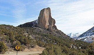
Needle Rock Natural Area is located at the western edge of the West Elk Mountains of Colorado. The surrounding terrain is characterized by laccolithic mountains flanked by precipitous cliffs, extensive talus aprons, forested mesas, canyons, and spacious, well-watered intermontane basins. Needle Rock is an intrusive plug of monzonite porphyry cropping out 3.5 miles (5.6 km) east-northeast of the Town of Crawford in Delta County, Colorado, United States. At an elevation of 7,797 feet (2,377 m), the towering rock spire stands 800 feet (240 m) tall above the floor of the Smith Fork of the Gunnison River valley. The massive rock feature originated in the Oligocene geological epoch when magma intruded between existing sedimentary rocks as the crown of a buried laccolith or possibly the underlying conduit of a laccolith. Subsequent erosion has exposed the prominent rock formation seen in the natural area today.

The Colorado River is a major river of the western United States and northwest Mexico in North America. Its headwaters are in the Rocky Mountains where La Poudre Pass Lake is its source. Located in north central Colorado it flows southwest through the Colorado Plateau country of western Colorado, southeastern Utah and northwestern Arizona where it flows through the Grand Canyon. It turns south near Las Vegas, Nevada, forming the Arizona–Nevada border in Lake Mead and the Arizona–California border a few miles below Davis Dam between Laughlin, Nevada and Needles, California California before entering Mexico in the Colorado Desert. Most of its waters are diverted into the Imperial Valley of Southern California. In Mexico its course forms the boundary between Sonora and Baja California before entering the Gulf of California. This article describes most of the major features along the river.
East Fork Little Cimarron River is a tributary of the Little Cimarron River in Gunnison County, Colorado. The stream flows north from a source in the Uncompahgre National Forest to a confluence with the Little Cimarron River.

Part of the Uncompahgre Project located on the western slope of central Colorado, the Taylor Park Dam was engineered by the Bureau of Reclamation. It is located on the Taylor River, a tributary of the Gunnison River, and the dam is used to create the Taylor Park Reservoir in Gunnison County, Colorado.
Currant Creek may refer to:
Henson Creek is a stream in Hinsdale County, Colorado, United States. It rises near Sunshine Mountain in the San Juan Mountains. It merges with Lake Fork Gunnison River in the town of Lake City, Colorado.


