
Smith Hill is a neighborhood in Providence, Rhode Island. Its traditional bounds are the Woonasquatucket River, the Chad Brown public housing complex, Interstate 95 and West River.

Saylesville is a village and historic district in Lincoln, Rhode Island.

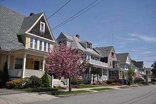
The College Hill Historic District is located in the College Hill neighborhood of Providence, Rhode Island, United States. It was designated a National Historic Landmark District on December 30, 1970. The College Hill local historic district, established in 1960, partially overlaps the national landmark district. Properties within the local historic district are regulated by the city's historic district zoning ordinance, and cannot be altered without approval from the Providence Historic District Commission.

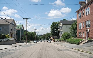
The Cato Hill Historic District is a residential historic district in central Woonsocket, Rhode Island. It consists of about 2-1/2 blocks of Church and Cato Streets, as well as the streets crossing them. The area, located on a hill just above Woonsocket's downtown area, is a densely populated area built primarily between 1838 and 1875, during Woonsocket's growth as a major textile processing center. Cato Hill is named for Cato Aldrich, an African American who purchased the land from the Arnolds who founded Woonsocket. The houses of the district exhibit vernacular forms of the architectural styles popular in the mid-19th century.

The South Central Falls Historic District is a historic district in Central Falls, Rhode Island. It is a predominantly residential area, densely populated, which was developed most heavily in the late 19th century. It is bounded roughly by Broad Street to the east, the Pawtucket city line to the south, Dexter Street to the west, and Rand Street and Jenks Park to the north. It has 377 contributing buildings, most of which were built before 1920. The district was added to the National Register of Historic Places in 1991.

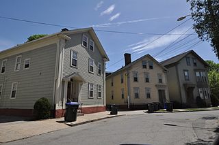
The Andrew Dickhaut Cottages Historic District encompasses a collection of historic worker cottages in the Smith Hill neighborhood of Providence, Rhode Island, along with the home of their builder, Andrew Dickhaut. The cottages are located at 114—141 Bath Street, 6-18 Duke Street, and the Dickhaut house is located at 377 Orms Street. The cottages are virtually identical 1-1/2 story wood frame structures, set on small lots close to the sidewalk. Those on Bath Street were built in 1882, while those on Duke Street were built in 1892. This collection represents a remarkably well-preserved collection of worker housing, a building form which is often poorly documented.

The Beaman and Smith Company Mill is an historic factory complex at 20 Gordon Avenue in Providence, Rhode Island. It consists of two masonry buildings at the junction of Gordon and Saratoga Streets in south Providence. The older of the two buildings is a one-to-two story brick structure, built in 1898 by the Berlin Iron Bridge Company. It has a steel frame, and is about 250 feet (76 m) long. The second building is an early example of concrete slab construction, built in 1917. It was designed by local aindustrial architecture firm, Jenks & Ballou. It is four stories in height, and is attached to the older building's south face. It originally had a brick surface, but much of this was stuccoed. The brick building presents four bays to Gordon Street, while the concrete one has two. The complex exemplifies two notable early modern construction methods, and is a symbol of the industrial development of south Providence in the late 19th century. Beaman and Smith was a manufacturer of precision machine tools; they went out of business in 1926. The complex was occupied for many years by the James Hill Manufacturing Company, who produced metal containers.
The Bridgham–Arch–Wilson Streets Historic District is a predominantly residential historic district in Providence, Rhode Island. It is located southwest of downtown Providence, and was developed beginning in the 1840s as a suburban part of the city. It is roughly in the shape of a boot, roughly bounded by Cranston, Bridgham, Elmwood, and Harrison Streets. Most of the housing is architecturally reflective of the mid-19th century, with the Greek Revival, Italianate, and Second Empire styles well represented. Development in the area slowed in the late 19th and early 20th centuries, so there are only a modest number of Queen Anne, Stick style, and Colonial Revival properties. Most of the houses are either 1-1/2 or 2-1/2 story wood frame structures, and are generally set on fairly small lots. There are 175 primary buildings in the district, of which more than 150 are historically significant.
The Doyle Avenue Historic District is a predominantly residential historic district on the East Side of Providence, Rhode Island. It extends along Doyle Avenue from North Main Street in the west to Proctor Place. This area was developed residentially between 1860 and 1920, with an architecturally diverse collection of houses, generally set on small lots with only modest setback from the sidewalk. Land on the south side of Doyle Avenue was owned by the Dexter Commission, which managed a large tract of land bequested to the city by Ebenezer Dexter. This land was originally leased to developers. One of the first houses built in this area was the c. 1875 Thomas Collins House at 33 Doyle Avenue, a 2-1/2 story Italianate duplex.

The Elmgrove Gardens Historic District is a residential historic district in northeastern Providence, Rhode Island, United States. It is bounded on the north by Rochambeau Street, on the south by Woodbury Street, on the east by Cole Street, and on the west by Morris Avenue. This area was developed most heavily between 1908 and 1948, and is a well-preserved example of an early automotive suburban residential area. Most of the houses in the district are either 1-1/2 or 2-1/2 stories in height, and are built in an architecturally diverse variety of styles. The district also includes to 18th-century farmhouses, reminders of the area's agrarian past.
Moshassuck Square is an industrial historic district in Providence, Rhode Island, lining the banks of the Blackstone Canal just north of the Rhode Island State House. It consists of the few surviving buildings of the once-extensive American Screw Company complex, which was largely developed between the 1840s and 1870s, and was a major fixture in the Providence landscape prior to its destruction by fire in 1971. The buildings are in an area bounded by Charles Street on the west, Stevens and Hewes Streets on the north, North Main Street to the east, and Mill Street to the south. Prominent among them are the Stillman White Foundry and Fletcher Manufacturing Company office building, which stand on opposite sides of Mill Street near its crossing of the canal. At 127 Charles Street stands a three-story brick building built c. 1900 as a retail and residential building. The only surviving elements of the Screw Company complex are located at North Main and Hewes Streets, and now house the Providence Center.

The Oakland Avenue Historic District is a residential historic district in the Smith Hill neighborhood of Providence, Rhode Island, USA. The area is a densely built stretch of Oakland and Pembroke Avenues, extending from Eaton Street in the north to about half-way between Chad Brown Street and Smith Street in the south. Only buildings on the east side of Pembroke are included, while both sides of Oakland Avenue are, as are a few properties on adjacent roads. All but two of the 110 buildings in the district are residential, and are set on small lots of similar size. The houses are almost all multi-unit, housing either two or three units, and were built in between 1890 and 1930. The district represents a dense and well-preserved collection of this type of housing in the city, and was one of its last "inner city" areas to be developed.

The Providence Jewelry Manufacturing Historic District is a predominantly industrial historic district in Providence, Rhode Island. It covers a roughly 19-acre (7.7 ha) area in the city's Jewelry District, just south of Downtown Providence. While the area began as a residential neighborhood, it emerged in the late 19th and early 20th centuries as a center of Providence's jewelry manufacturing businesses. The oldest industrial building in the district is the 1848 Elm Street Machine Shop, a 2+1⁄2-story stone structure that now houses offices of Brown University.

Rhodes Street Historic District is a residential historic district encompassing one block of Rhodes Street in southern Providence, Rhode Island, along with the dead-end Janes and Alphonso Streets. This area has a well-preserved collection of stylish 19th century houses, built roughly between 1850 and 1895. South Providence did not see much residential development until after industry began moving into the area. These houses were built on land that was originally part of the Rhodes family farm, and were built for managers of nearby industrial facilities. Architecturally the houses represent a cross-section of styles popular in the period.

The Smith Street Primary School is an historic school at 396 Smith Street in Providence, Rhode Island. It is a large 2-1/2 story brick structure with a cross-gable roof. It was designed in Queen Anne style by William R. Walker & Son and built in 1885. The building occupies its site at an unusual angle, partially overhanging the sidewalk, and has an asymmetrical interior, a departure from the other schools the Walkers designed for the city.

The Wayland Historic District is a predominantly residential historic district on the east side of Providence, Rhode Island. It is a large area, covering about 122 acres (49 ha), bounded roughly on the north by Everett and Laurel Avenues, on the east by Blackstone Boulevard and Butler Avenue, on the west by Arlington Avenue, and on the south by Angell and South Angell Streets. This area, which was in the 19th century part of the Moses Brown farm, was platted for development in 1891, with most of the construction taking place in the early decades of the 20th century. Most of the residential properties in the district are single-family houses, typically built in revival styles popular at the time. They are set on similarly-sized lots with fairly uniform setbacks, and were typically built without garages. There are a number of two-family houses, and a small number of apartment buildings, most of which are found on the arterial roads of the area. There are several religious buildings, including several churches; the most architecturally distinctive religious building is the Jewish Temple Beth El, built 1951–54.
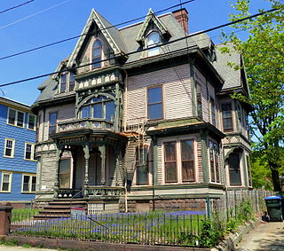
The Wesleyan Avenue Historic District is a residential historic district in the Elmwood section of Providence, Rhode Island. It includes 25 houses, on a one-block section of Wesleyan Avenue between Taylor and Broad Streets, with a few of them on the two end streets. They are large two-plus story wood frame houses, set on modest lot, all of which were built between 1875 and 1900. The houses are in a diversity of styles popular at that time, including Second Empire, Stick style, and Queen Anne. The district includes what is one of Providence's finest Stick style houses, the Samuel Darling House at 53 Wesleyan Avenue. It was built in 1885, and displays a wealth of applied wood work, decorative shingling, and intricately carved porch details.

The Manville Company Worker Housing Historic District is a residential historic district encompassing an area of mill worker housing in the Manville village of Lincoln, Rhode Island. The district covers about 50 acres (20 ha) of the village, including properties on Angle, Main, Old Main, Spring, Summer, Winter, and Chestnut Streets, as well as several properties on adjoining roads, describing a crescent, part of which abuts the south bank of the Blackstone River. The housing in this district was built between about 1812 and 1890 by the various proprietors of the Manville Company, and feature a diversity of architectural styles, most of which are simple vernacular interpretations of styles popular at the time. Most of the houses are either 1-1/2 or 2-1/2 stories in height, with one or two units per structure, and are set on small lots. There are also a series of brick rowhouses, a relative rarity in Rhode Island mill housing of the period.

The Edgewood Historic District–Aberdeen Plat is a residential historic district in the Edgewood neighborhood of eastern Cranston, Rhode Island. Bounded by Berwick Lane and Sefton Drive to the north, Broad Street to the west, Chiswick Road to the south, and the Providence River to the east, this area was developed between 1901 and 1957 as a streetcar suburb for middle and upper middle class residents on what was once a country estate. The district was listed on the National Register of Historic Places in 2016.
The Edgewood Historic District–Sally Greene Homestead Plats is a residential historic district in the Edgewood neighborhood of eastern Cranston, Rhode Island. Bounded by Glen Avenue to the north, Broad Street to the west, Massasoit Street to the south, and the Providence River to the east, this area was developed between 1900 and 1963 as a streetcar suburb for middle and lower middle class residents on what was once a country estate. The district was listed on the National Register of Historic Places in 2016.


