
Sharpenhoe is a small village in Bedfordshire, England, at the foot of the hills known as the Sharpenhoe Clappers, which are within the Chilterns AONB. Smithcombe, Sharpenhoe and Sundon Hills are a Site of Special Scientific Interest, and most of it is a National Trust property. It is in the civil parish of Streatley.

Ashridge Commons and Woods is a 640.1 hectare biological Site of Special Scientific Interest in Buckinghamshire and Hertfordshire. It is located in Little Gaddesden, and is part of the National Trust Ashridge Estate in the Chilterns Area of Outstanding Natural Beauty.
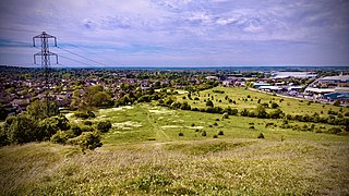
Blow's Down is a 33.1-hectare (82-acre) biological Site of Special Scientific Interest in Dunstable in Bedfordshire. It was notified in 1989 under Section 28 of the Wildlife and Countryside Act 1981, and the local planning authority is Central Bedfordshire Council. The site forms around half of the 62.3-hectare (154-acre) Blow's Downs nature reserve, which is managed by the Wildlife Trust for Bedfordshire, Cambridgeshire and Northamptonshire.

Totternhoe Knolls is a 13.1-hectare (32-acre) Site of Special Scientific Interest (SSSI) in Totternhoe in Bedfordshire. It is also a local nature reserve, and part of the Chilterns Area of Outstanding Natural Beauty. The site is owned by Central Bedfordshire Council and leased to the National Trust. Most of the site is maintained jointly by the National Trust and the Wildlife Trust for Bedfordshire, Cambridgeshire and Northamptonshire (WTBCN), and is part of the WTBCN Totternhoe nature reserve, which also includes Totternhoe Chalk Quarry and Totternhoe Stone Pit. The SSSI also includes Totternhoe Castle, the earthworks of a Norman motte-and-bailey castle which is a Scheduled monument.

Totternhoe Chalk Quarry is a 13.4-hectare (33-acre) biological Site of Special Scientific Interest in Totternhoe in Bedfordshire. Part of it lies in Totternhoe nature reserve, which is managed by the Wildlife Trust for Bedfordshire, Cambridgeshire and Northamptonshire. The site is part of the Chilterns Area of Outstanding Natural Beauty.

Dunstable and Whipsnade Downs is a 73.4-hectare (181-acre) Site of Special Scientific Interest in Dunstable in Bedfordshire. It was notified in 1987 under Section 28 of the Wildlife and Countryside Act 1981, and the local planning authority is Central Bedfordshire Council. It is in the Chilterns Area of Outstanding Natural Beauty, and part of it is owned by the National Trust.

Bacombe and Coombe Hills is a 76.4-hectare (189-acre) biological Site of Special Scientific Interest in Upper Bacombe in Buckinghamshire. Bacombe Hill was formerly owned by Buckinghamshire County Council, which transferred it to Berkshire, Buckinghamshire and Oxfordshire Wildlife Trust in 2014. Coombe Hill is owned by the National Trust.

Bradenham Woods, Park Wood and The Coppice is a 129.1-hectare (319-acre) biological Site of Special Scientific Interest in Bradenham in Buckinghamshire. It is in the Chilterns Area of Outstanding Natural Beauty, and it is described in A Nature Conservation Review. The site is part of the Bradenham Estate, which is owned by the National Trust. It is also designated a Special Area of Conservation. Grim's Ditch, a Scheduled Monument, runs through the site.

Ellesborough and Kimble Warrens is a 68.9-hectare (170-acre) biological Site of Special Scientific Interest in Ellesborough in Buckinghamshire. The local planning authority is Wycombe District Council. It is part of the Chilterns Area of Outstanding Natural Beauty.

Grangelands and Pulpit Hill is a 25.5-hectare (63-acre) biological Site of Special Scientific Interest in Cadsden in Buckinghamshire. It lies within the Chilterns Area of Outstanding Natural Beauty, and the planning authorities are Wycombe District Council and Buckinghamshire County Council.

Sundon Chalk Quarry is a 26.2-hectare (65-acre) biological Site of Special Scientific Interest in Upper Sundon in Bedfordshire. It was notified in 1989 under Section 28 of the Wildlife and Countryside Act 1981, and the local planning authority is Central Bedfordshire Council. The site is privately owned but there is free public access.

Hollowhill and Pullingshill Woods is a 23-hectare biological Site of Special Scientific Interest near Marlow in Buckinghamshire. It is in the Chilterns Area of Outstanding Natural Beauty, and the Chilterns Beechwoods Special Area of Conservation. The local planning authorities are Wycombe District Council and Buckinghamshire County Council. Pullingshill Wood is owned by the Woodland Trust, and Hollowhill Wood was formerly owned by Buckinghamshire County Council, but was transferred to the Berkshire, Buckinghamshire and Oxfordshire Wildlife Trust. Since November 2015 the 7.8-hectare site has been managed by the Trust as "Hog and Hollowhill Woods".

Ivinghoe Hills is a 210.4 hectares Site of Special Scientific Interest in Ivinghoe in Buckinghamshire, and part of the Chilterns Area of Outstanding Natural Beauty. It is listed in A Nature Conservation Review. The Ridgeway long-distance footpath ends and the Icknield Way Path starts in the site on Ivinghoe Beacon. An Iron Age fort on Ivinghoe Beacon and a tumulus on Gallows Hill are Scheduled Monuments. The site is part of the National Trust's Ashridge Estate, apart from a small area which belongs to Buckinghamshire County Council.
Millfield Wood is a 9.5-hectare (23-acre) biological Site of Special Scientific Interest north of High Wycombe in Buckinghamshire. It is owned and managed by the Berkshire, Buckinghamshire and Oxfordshire Wildlife Trust, and it is in the Chilterns Areas of Outstanding Natural Beauty.

Turville Hill is a 22.4-hectare (55-acre) biological Site of Special Scientific Interest in Turville in Buckinghamshire. It is in the Chilterns Area of Outstanding Natural Beauty. Cobstone Windmill, also known as Turville Windmill, is located at the top.

Buttlers Hangings is a 3.9-hectare (9.6-acre) Site of Special Scientific Interest north of West Wycombe in Buckinghamshire. It is in the Chilterns Area of Outstanding Natural Beauty.

Shirburn Hill is a 63.7-hectare (157-acre) biological Site of Special Scientific Interest just outside and to the northeast of Watlington, Oxfordshire.
