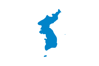
Korea is a peninsular region in East Asia. Since 1945,it has been divided at or near the 38th parallel,now known as the Korean Demilitarized Zone. In 1948,two states declared independence,both claiming sovereignty over all of Korea:South Korea comprising its southern half and North Korea comprising its northern half. The region consists of the Korean Peninsula,Jeju Island,and a number of minor islands near the peninsula. The peninsula is bordered by China (Manchuria) to the north and Russia to the northeast,across the Amnok and Duman rivers. It is separated from Japan to the southeast by the Korea Strait.

North Korea is located in East Asia in the Northern half of Korea,partially on the Korean Peninsula. It borders three countries:China along the Yalu (Amnok) River,Russia along the Tumen River,and South Korea to the south.
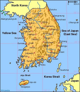
South Korea is located in East Asia,on the southern portion of the Korean Peninsula located out from the far east of the Asian landmass. The only country with a land border to South Korea is North Korea,lying to the north with 238 kilometres (148 mi) of the border running along the Korean Demilitarized Zone. South Korea is mostly surrounded by water and has 2,413 kilometres (1,499 mi) of coast line along three seas;to the west is the Yellow Sea,to the south is the East China Sea,and to the east is the Sea of Japan. Geographically,South Korea's landmass is approximately 100,032 square kilometres (38,623 sq mi). 290 square kilometres (110 sq mi) of South Korea are occupied by water. The approximate coordinates are 37°North,128°East.

Yemen is located in West Asia,at the southern tip of the Arabian Peninsula,between Oman and Saudi Arabia. It is situated at the entrance to the Bab-el-Mandeb Strait,which links the Red Sea to the Indian Ocean and is one of the most active and strategic shipping lanes in the world. Yemen has an area of 555,000 square kilometres (214,000 sq mi),including the islands of Perim at the southern end of the Red Sea and Socotra at the entrance to the Gulf of Aden. Yemen's land boundaries total 1,746 kilometres (1,085 mi). Yemen borders Saudi Arabia to the north and Oman to the northeast. Through the Socotra island,Yemen also shares borders with the Guardafui Channel and the Somali Sea.

The Santa Cruz Mountains are a mountain range in central and Northern California,United States,constituting a part of the Pacific Coast Ranges. They form a ridge down the San Francisco Peninsula,south of San Francisco. They separate the Pacific Ocean from the San Francisco Bay and the Santa Clara Valley,and continue south to the Central Coast,bordering Monterey Bay and ending at the Salinas Valley. The range passes through the counties of San Mateo,Santa Clara,and Santa Cruz,with the Pajaro River forming the southern boundary.
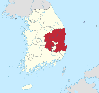
North Gyeongsang Province is a province in eastern South Korea,and with an area of 19,030 km2 (7,350 sq mi),it is the largest province in the Korean peninsula. The province was formed in 1896 from the northern half of the former Gyeongsang province,and remained a province of Korea until the country's division in 1945,then became part of South Korea.

North Jeolla Province,also known as Jeonbuk,is a province of South Korea in the Honam region in the southwest of the Korean Peninsula. North Jeolla borders the provinces of South Chungcheong to the north,North Gyeongsang and South Gyeongsang to the east and South Jeolla to the south. North Jeolla was established in 1896 from the northern part of the old Jeolla province,one of the Eight Provinces of Korea.

Gayasan National Park,also known as Gaya Mountain National Park,is a large national park in the eastern part of South Korea. The park is named in honor of Gaya Mountain and became a National Park in 1972.

The Taebaek Mountains (Korean: 태백산맥) are a mountain range that stretches across North Korea and South Korea. They form the main ridge of the Korean peninsula.
Jirisan (Korean: 지리산) is a mountain located in the southern region of South Korea. It is the second-tallest mountain in South Korea after Jeju Island's Hallasan,and the tallest mountain in mainland South Korea.

Mungyeong is a city in North Gyeongsang Province,South Korea. The local government,economy,and transportation networks are all centered in Jeomchon,the principal town. Mungyeong has a lengthy history,and is known today for its various historic and scenic tourist attractions. The city's name means roughly "hearing good news." Recently,development has been somewhat stagnant with the decline of the coal industry. Since the 1990s,the proportion of people who rely on the tourism industry through Mungyeong Saejae has gradually increased.
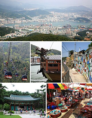
Tongyeong is a coastal city in South Gyeongsang Province,South Korea. In 2010,it had an area of 238.81 km2 (92.21 sq mi) and a population of 139,869 people. It is divided into 1 eup (town),6 myeon (township) and 11 dong (neighborhood). Chungmu city and Tongyeong county were reunited in 1995,creating Tongyeong City as it is known today. It consists of Goseong Peninsula,Hansan Island,Mireuk Island,Yokji Island and other islets. It was formerly known as Chungmu,after the posthumous name of Admiral Yi Sun-sin. The name Tongyeong means "command post" and is itself associated with Admiral Yi,as it refers to his principal base that was located on nearby Hansan Island.

Korea comprises the Korean Peninsula and 3,960 nearby islands. The peninsula is located in Northeast Asia,between China and Japan. To the northwest,the Amnok River separates Korea from China and to the northeast,the Duman River separates Korea from China and Russia. The Yellow Sea lies to the west,the East China Sea and Korea Strait to the south,and the Korean East Sea to the east. Notable islands include Jeju Island (Jejudo),Ulleung Island (Ulleungdo),and the Liancourt Rocks.
The Rangnim Mountains are a mountain range stretching from north to south,west of the Kaema Highlands,in central North Korea. They are the source of several major rivers of North Korea,such as the Taedong and the Ch'ŏngch'ŏn. The mountain range is generally highest in the east,and falls towards the west. Its highest peak is Wagalbong,at 2,260 m. Lake Rangrim is located in the mountins.

Baekdu-daegan is a traditional Korean conception of the mountains and consequently the watersheds of the Korean peninsula. The mountain range stretches the length of the Korean peninsula,around 1500 km,from Baekdu Mountain in the north to Jirisan or Hallasan on Jeju Island in the south. The mountain range is often associated with national identity and traditional Korean shamanism.
Deogyusan,formerly spelled Togyusan,is a mountain in South Korea. Its highest peak is 1,614 meters above sea level.
Myeongseongsan is a mountain in South Korea. Its area extends across the city of Pocheon,Gyeonggi-do and Cheorwon County,Gangwon-do. It has an elevation of 922.6 m (3,027 ft).

Greece is a country in Southeastern Europe,on the Balkan Peninsula. It is bordered to the north by Albania,North Macedonia and Bulgaria;to the east by Turkey,and is surrounded to the east by the Aegean Sea,to the south by the Cretan and the Libyan seas,and to the west by the Ionian Sea which separates Greece from Italy.
Indira Col West is a mountain pass at 5,988 metres (19,646 ft)) altitude on the Indira Ridge of Siachen Muztagh in Karakoram Range. It is on the border between Indian-controlled Siachen Glacier and the Chinese-controlled Trans-Karakoram Tract,close to the tripoint of India,Pakistan,and China. The India-Pakistan Actual Ground Position Line (AGPL) in the Siachen area ends near the pass. It is possible to ascend the pass from both the north and south sides controlled by China and India respectively.

Jong Il Peak is one of the peaks of Mount Sobaek,south-east of Paektu Mountain. The height is 5,899 ft (1,798 m). It is located near the shore of Sobaek Stream,in Samjiyon County,Ryanggang Province,North Korea.

