Sogn og Fjordane was up to 1 January 2020 a county in western Norway, when it was merged to become part of Vestland county. Bordering previous counties Møre og Romsdal, Oppland, Buskerud, and Hordaland, the county administration was in the village of Hermansverk in Leikanger municipality. The largest town in the county was Førde.

Luster is a municipality in Vestland county, Norway. It is located at the end of the Sognefjorden in the traditional district of Sogn. The administrative centre is the village of Gaupne. Other villages in Luster include Fortun, Hafslo, Indre Hafslo, Jostedal, Luster, Nes, Ornes, Skjolden, Solvorn, and Veitastrond.

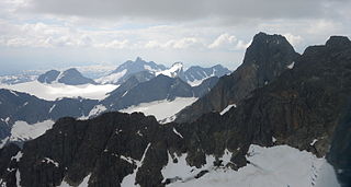
Jotunheimen is a mountainous area of roughly 3,500 km² in southern Norway and is part of the long range known as the Scandinavian Mountains. The 29 highest mountains in Norway are all in Jotunheimen, including the very highest - Galdhøpiggen. Jotunheimen straddles the border between the counties of Oppland and Sogn og Fjordane.

Lom is a municipality in Innlandet county, Norway. It is part of the traditional region of Gudbrandsdal. The administrative centre of the municipality is the village of Fossbergom. The municipality of Lom was established on 1 January 1838. The area of Skjåk was separated from Lom to become a municipality of its own in 1866.

JotunheimenNational Park is a national park in Norway, recognized as one of the country's premier hiking and fishing regions. The national park covers 1,151 square kilometres (444 sq mi) and is part of the larger area Jotunheimen. More than 250 peaks rise above an elevation of 1,900 metres (6,200 ft), including Northern Europe's two highest peaks: Galdhøpiggen at 2,469 metres (8,100 ft), and Glittertind at 2,465 metres (8,087 ft).

Øvre Årdal is a village in the municipality of Årdal in Vestland county, Norway. It is the larger of the two primary villages in Årdal. The village is situated at the northern end of the 9-kilometre (5.6 mi) long lake Årdalsvatnet, with the village of Årdalstangen at the southern end. The 1.87-square-kilometre (460-acre) village has a population (2013) of 3,206; giving the village a population density of 1,714 inhabitants per square kilometre (4,440/sq mi). Farnes Church is located in this village. The road Tindevegen goes from Øvre Årdal, through the Fardalen valley to Turtagrø in Luster municipality. It's one of the highest elevation roads in Norway. There is also a road which goes south past the lake Tyin to the European route E16 highway which goes through Valdres to Oslo.

Gaupne is the administrative center of the municipality of Luster in Vestland county, Norway. The village is located along the Gaupnefjorden, an arm of the Lustrafjorden, about 10 kilometres (6.2 mi) north of the village of Hafslo. The village of Veitastrond is located across the mountains 20 kilometres (12 mi) to the northwest. The Sognefjellsvegen road passes through here on its way to the village of Skjolden and beyond.

The Otta Valley is a valley in the municipalities of Skjåk, Lom, Vågå, and Sel in the county of Oppland, Norway.

Fossbergom is the administrative centre of Lom municipality, Innlandet county, Norway. Its population is 837. Fossbergom is a modern community, in which most people work in tourism, commerce and the service sector.
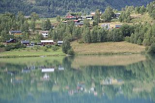
Skjolden is a village in the municipality of Luster in Vestland county, Norway. It is located at the end of the Lustrafjorden, a branch of the Sognefjorden. Skjolden is located at the innermost point of the Sognefjorden, Norway's longest fjord, and the length of the Sognefjorden is measured from Skjolden to the island of Ytre Sula where the fjord meets the ocean—over 200 km. The valleys of Mørkridsdal and Fortunsdal meet at Skjolden, just west of the Hurrungane mountains. Skjolden is home to about 200 people.

Jostedal is a former municipality in the old Sogn og Fjordane county in Norway. The 533-square-kilometre (206 sq mi) municipality existed from 1838 until its dissolution in 1963. It was located in the Jostedalen valley in the northern part of the present-day municipality of Luster, north of the village of Gaupne. The administrative centre was located near the Jostedal Church in the central part of the valley.
Fannaråki is a mountain in the municipality of Luster in Vestland county, Norway. The 2,068-metre (6,785 ft) tall mountain is located in the Jotunheimen National Park, just south of the lake Prestesteinsvatnet and the Sognefjellsvegen road. This mountain is located about 6 kilometres (3.7 mi) north of the Skagastølstindane mountains.
Prestesteinsvatnet is a lake in Luster Municipality in Vestland county, Norway, with a small part of the lake crossing over into the neighboring Lom Municipality in Innlandet county. The 4.12-square-kilometre (1,020-acre) lake sits at an elevation of 1,357 metres (4,452 ft) above sea level. It lies along the south side of the Sognefjellsvegen road, just to the north of the mountain Fannaråki and the Fannaråkbreen glacier. The lake sits just outside the borders of Jotunheimen National Park. The village of Skjolden lies about 20 kilometres (12 mi) to the southwest of the lake.
Hurrungane is a mountain range in the municipalities Luster and Årdal in Vestland county, Norway. The area is southwest in the larger mountain range Jotunheimen and is also part of Jotunheimen National Park.

Breheimen is a mountain range in the Vestland and Innlandet counties in Norway. The area lies west of the Jotunheimen mountain range. The mountain range lies to the northwest of the Sognefjellsvegen road, north of the Sognefjorden, south of the Nordfjorden and Norwegian National Road 15, and east of Norwegian National Road 5 and European route E39. The mountain range includes Jostedalsbreen National Park and Breheimen National Park.

Breheimen National Park is a national park that was established in 2009. The park is located in the municipalities of Skjåk and Lom in Innlandet county and in Luster in Vestland county, Norway. The park covers 1,671 square kilometres (645 sq mi) of the Breheimen mountain range.

Turtagrø is a hotel in the municipality of Luster in Sogn og Fjordane county, Norway, near Hurrungane in Jotunheimen. The hotel has been a central meeting place for mountaineers from the late 1800s.
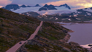
Sognefjellet is a mountain pass which connects Lustrafjorden with Ottadalen through Jotunheimen area. The pass is located in Luster and Lom, Norway. Sognefjellsvegen, part of County Road 55, runs through the pass.
Juvasshytta is a mountain tourist station with restaurant and accommodation, located in Jotunheimen, in Lom municipality, Norway.
Jostedalen is a river valley in Luster Municipality in Vestland county, Norway. The 60-kilometre (37 mi) long valley runs from the Lustrafjorden at the village of Gaupne, to the north along the river Jostedøla and along the eastern side of the Jostedal Glacier. The valley is deep, but the valley floor lies over long stretches of flat river plains interrupted by steep steps. In the north, the landscape gets pretty wild. The Jostedalsbreen National Park surrounds the valley, which brings a lot of tourism to the area. The Nigardsbreen glacier is also accessible from the valley.