Leyte is an island in the Visayas group of islands in the Philippines. It is eighth-largest and sixth-most populous island in the Philippines, with a total population of 2,626,970 as of 2020 census.

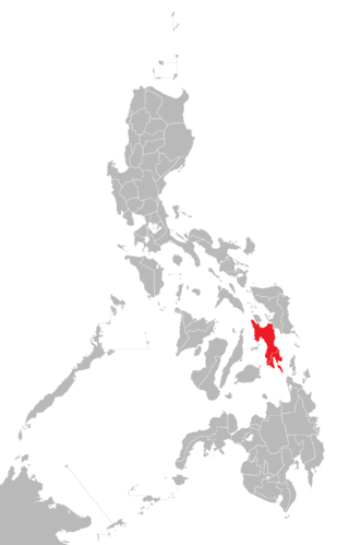
Southern Leyte, officially the Province of Southern Leyte, is a province in the Philippines located in the Eastern Visayas region. Its capital is the city of Maasin. Southern Leyte comprised the third congressional district Leyte until it was made into an independent province in 1959. Southern Leyte includes Limasawa, an island to the south where the first Roman Catholic Mass in Philippine soil is believed to have taken place and thus considered to be the birthplace of Roman Catholicism in the Philippines.

Chilika Lake is the largest brackish water lagoon in Asia and second largest coastal lagoon in the world, spread over the Puri, Khordha and Ganjam districts of Odisha state on the east coast of India, at the mouth of the Daya River, flowing into the Bay of Bengal, covering an area of over 1,100 square kilometres (420 sq mi).

Padre Burgos, officially the Municipality of Padre Burgos, is a 5th class municipality in the province of Southern Leyte, Philippines. According to the 2020 census, it has a population of 11,159 people.
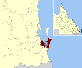
Redland City, better known as the Redlands and formerly known as Redland Shire, is a local government area and a part of the Brisbane metropolitan area in South East Queensland, Australia. With a population of 159,222 in June 2021, the city is spread along the southern coast of Moreton Bay, covering 537.2 square kilometres (207.4 sq mi). Its mainland borders the City of Brisbane to the west and north-west, and Logan City to the south-west and south, while its islands are situated north of the City of Gold Coast.

Silago, officially the Municipality of Silago, is a 4th class municipality in the province of Southern Leyte, Philippines. According to the 2020 census, it has a population of 13,116 people. It was used to be barrio of Hinunangan until Executive Order No. 326 dated May 17, 1950 separated it from the mother town. The town has an ebony beach with unique black sand.
Sand mining is the extraction of sand, mainly through an open pit but sometimes mined from beaches and inland dunes or dredged from ocean and river beds. Sand is often used in manufacturing, for example as an abrasive or in concrete. It is also used on icy and snowy roads usually mixed with salt, to lower the melting point temperature, on the road surface. Sand can replace eroded coastline. Some uses require higher purity than others; for example sand used in concrete must be free of seashell fragments.

Maasin, officially the City of Maasin, is a 4th class component city and capital of the province of Southern Leyte, Philippines. According to the 2020 census, it has a population of 87,446 people.
Bontoc, officially the Municipality of Bontoc, is a 4th class municipality in the province of Southern Leyte, Philippines. According to the 2020 census, it has a population of 29,799 people.
Hinunangan, officially the Municipality of Hinunangan, is a 3rd class municipality in the province of Southern Leyte, Philippines. According to the 2020 census, it has a population of 29,149 people.

Libagon, officially the Municipality of Libagon, is a 5th class municipality in the province of Southern Leyte, Philippines. According to the 2020 census, it has a population of 15,244 people.

Malitbog, officially the Municipality of Malitbog, is a 4th class municipality in the province of Southern Leyte, Philippines. According to the 2020 census, it has a population of 23,256 people.

Saint Bernard, officially the Municipality of Saint Bernard, is a 4th class municipality in the province of Southern Leyte, Philippines. According to the 2020 census, it has a population of 28,414 people.

Sogod, officially the Municipality of Sogod, is a 2nd class municipality in the province of Southern Leyte, Philippines. According to the 2020 census, it has a population of 47,552 people.

The MeenachilRiver or Meenachilaar, also known as Kavanar, Valanjar, is a river in Kerala. It is one of the most treacherous rivers in Kerala due to its flash floods, heavy undercurrents and woods and debris it carries from the mountains. It flows through the heart of Kottayam district, Kerala state in southern India. 78km long, originates in the Western Ghats main tributaries are Theekoy aaru from Vagamon hills, Poonjar Aaru and Chittar, flowing westward through the city of Kottayam and other towns like Poonjar, Teekoy, Erattupetta, Bharananganam, Pala, Mutholy, Cherpunkal, Kidangoor and Kumarakom before emptying into the Vembanad Lake on the shore of the Indian Ocean.
The mining industry in India is a major economic activity which contributes significantly to the economy of India. The gross domestic product (GDP) contribution of the mining industry varies from 2.2% to 2.5% only but going by the GDP of the total industrial sector, it contributes around 10% to 11%. Even mining done on small scale contributes 6% to the entire cost of mineral production. Indian mining industry provides job opportunities to around 700,000 individuals.

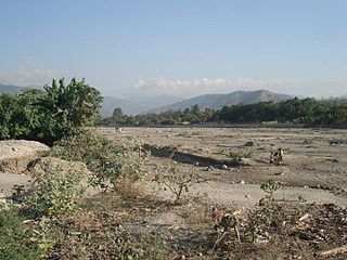
The Subangdaku River is the largest river in Southern Leyte, Philippines. It drains into the Sogod Bay at the municipality of Sogod. The river's name means "big river" or "wide river" in Cebuano.
The Comoro River is a river in East Timor. It flows north into Ombai Strait, reaching the coast in the north western suburbs of the capital, Dili. In its lower reaches, it is the main and largest of Dili's four major rivers.
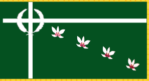
The Flag of Southern Leyte is the provincial flag of Southern Leyte, Philippines. It is a green field with thin white horizontal and vertical stripes meeting within the upper hoist quarter of the flag to form an offset cross; upon this cross is a wreath composed of an abaca leaf and a palm frond, while four "Star of Leyte" orchid flowers are set in a descending diagonal line from the cross intersection to the lower fly.
Eastern Visayas is an administrative region in the Philippines, designated as Region VIII. It consists of three main islands, Samar, Leyte and Biliran. The region has six provinces, one independent city and one highly urbanized city namely, Biliran, Leyte, Northern Samar, Samar, Eastern Samar, Southern Leyte, Ormoc and Tacloban. The highly urbanized city of Tacloban is the sole regional center. These provinces and cities occupy the easternmost islands of the Visayas group of islands.


