Solidaridad Municipality

Last updated
Playa del Carmen
Playa del Carmen
Solidaridad
Solidaridad QR.jpg
Welcome sign over Highway 307
Flag of Solidaridad, Quintana Roo.svg
Escudo de Solidaridad.svg
Solidaridad en Quintana Roo.svg
Location of Solidaridad in Quintana Roo
Mexico States blank map.svg
Red pog.svg
Playa del Carmen
Location within Mexico
Coordinates: 20°37′N87°05′W / 20.617°N 87.083°W / 20.617; -87.083 Coordinates: 20°37′N87°05′W / 20.617°N 87.083°W / 20.617; -87.083
Country Mexico
State Quintana Roo
Established28 July 1993
Municipal seat Playa del Carmen
Government
  Municipal President Lili Campos
Area
[1]
   Municipality 2,278 km2 (880 sq mi)
Elevation
10 m (30 ft)
Population
 (2020 census)
   Municipality 333,800
  Density150/km2 (380/sq mi)
   Urban
155,902
Time zone UTC−5 (Southeast (US Eastern))
Area code 984
INEGI Code23008
Website https://gobiernodesolidaridad.gob.mx

Solidaridad is one of the eleven municipalities that make up the Mexican state of Quintana Roo. Its municipal seat is the town of Playa del Carmen.

Contents

Solidaridad is home to the Maya archaeological site of Xcaret. [2]

Geography

The municipality has some small but rich continental sites including the ecotourism park of Xcaret. Prior to the creation of the Municipality of Tulum, the municipality was situated between latitudes 20° 45' and 19° 46' north and longitudes 86° 57' and 88° 05' west, and had an area of 4,245.67 square kilometres (1,639.26 sq mi). Today, it borders the municipalities of Benito Juárez and Lázaro Cárdenas to the north and Tulum to the south; and is separated in most places from its neighboring municipality to the east (Cozumel) by a stretch of the Caribbean Sea known as the Cozumel Channel.

The ecotourism park of Xel-Ha and the Calica limestone quarry are not part of Solidaridad as they belong to the neighboring municipality of Cozumel. These are the only two mainland locations for the municipality of Cozumel with sizes of 90 hectares (220 acres) and 11.9 hectares (29 acres) respectively. All of the limestone from Calica is exported to the US, and the quarry has its own docks and also serves visiting cruise ships. [2]

Orography and hydrography

Like most of the Yucatan Peninsula, Solidaridad is almost entirely flat with a gentle slope towards the sea, so from west to east, most of the area never reaches an altitude above 25 metres (82 ft) above sea level.

Like the rest of the peninsula's surface the land has a limestone base that does not allow the formation of surface water flows such as rivers and streams, the water instead form flows in underground rivers that sometimes rise to the surface in the cenotes. Lakes and cenotes are the major water bodies of the municipality.

Communities

The largest localities (cities, towns, and villages) are: [3]

NamePopulation
(2010 census)
Playa del Carmen 149,923
Puerto Aventuras 5,979
Barceló Maya606
Grand Palladium334
Cárcel Pública314
Iberostar242
Felipe Carrillo Puerto176
Punta Laguna138
El Dorado131
Hidalgo y Cortez128
Grand Sirenis125
Total municipality159,310

History

Solidaridad is one of the youngest municipalities in the country: it was formed on July 28, 1993, by decree of the State Congress during the administration of Mario Villanueva Madrid. At this time the municipality of Cozumel was split into two, with the mainland section constituting the new municipality of Solidaridad.

On March 13, 2008, Solidaridad was split in two when the new Municipality of Tulum was formed, as a result its land area and population were adjusted. [4]

Historical population
YearPop.±% p.a.
1995 28,747    
2000 63,752+17.27%
2005 135,512+16.28%
2010 159,310+3.29%
Source: INEGI Instituto Nacional de Estadística y Geografía [5]

Demographics

The municipality has a population of 159,310 according to the results of the Population and Housing Census of 2010 conducted by the National Institute of Statistics and Geography (Instituto Nacional de Estadística y Geografía), of these, 83,468 are men and 75,842 are women. [3] By this time, Tulum Municipality was already separated from Solidaridad.

Currently most of its population are immigrants, mainly from the southeastern states of Mexico; but also, according to the National Institute of Migration, Mexico (Instituto Nacional de Migración de México), the municipality has 12 percent of its population of foreign origin.


Solidaridad.JPG
Playa del Carmen, seat of the municipality

Related Research Articles

<span class="mw-page-title-main">Quintana Roo</span> State of Mexico

Quintana Roo, officially the Free and Sovereign State of Quintana Roo, is one of the 31 states which, with Mexico City, constitute the 32 federal entities of Mexico. It is divided into 11 municipalities, and its capital city is Chetumal.

<span class="mw-page-title-main">Playa del Carmen</span> City in Quintana Roo, Mexico

Playa del Carmen, known colloquially as 'Playa', is a resort city located along the Caribbean Sea in the state of Quintana Roo, Mexico. It is part of the municipality of Solidaridad. As of 2020, the city's population was just over 300,000 people, a small yet thriving portion of which are foreign expats.

<span class="mw-page-title-main">Municipalities of Quintana Roo</span>

Quintana Roo is a state in southeast Mexico established out of the Quintana Roo Territory in 1974 with seven municipalities, which has since grown into eleven municipalities. According to the 2020 Mexican census, it has the twenty-fourth largest population of all states with 1,857,985 inhabitants and is the 19th largest by land area spanning 44,705.2 square kilometres (17,260.8 sq mi).

<span class="mw-page-title-main">Riviera Maya</span> Tourist resort district near Cancún, Mexico

The Riviera Maya is a tourism and resort district south of Cancun, Mexico. It straddles the coastal Federal Highway 307, along the Caribbean coastline of the state of Quintana Roo, located in the eastern portion of the Yucatán Peninsula. Historically, this district started at the city of Playa del Carmen and ended at the village of Tulum, although the towns of Puerto Morelos, situated to the north of Playa del Carmen, as well as the town of Felipe Carrillo Puerto, situated 40 km (25 mi) to the south of Tulum, are both currently being promoted as part of the Riviera Maya tourist corridor.

<span class="mw-page-title-main">San Miguel de Cozumel</span> Place in Quintana Roo, Mexico

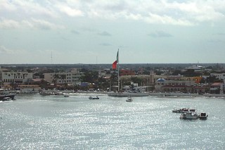
San Miguel de Cozumel is the largest city in Cozumel Municipality in the Mexican state of Quintana Roo. With a 2010 census population of 77,236, it is also Quintana Roo's fourth-largest community, after Cancún, Chetumal, and Playa del Carmen. It is a hub for tourism on the Riviera Maya, providing the sole ferries between the Mexican mainland and the island. In addition to the ferry service to Playa del Carmen, the first international cruise terminal in Quintana Roo is located in the city.

<span class="mw-page-title-main">Tunkás Municipality</span> Municipality in Yucatán, Mexico

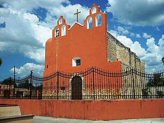
Tunkás Municipality is one of the 106 municipalities in the Mexican state of Yucatán containing 514.79 square kilometres (198.76 sq mi) of land and located roughly 98 kilometres (61 mi) east of the city of Mérida.

<span class="mw-page-title-main">Calica</span>

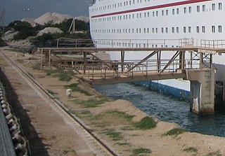
Calica is a quarry and a port on the Quintana Roo coast of Mexico. The name is short for the full Spanish name Calizas Industriales del Carmen, "calizas" Spanish for lime or limestone

<span class="mw-page-title-main">Tulum, Quintana Roo</span> Town in Quintana Roo, Mexico

Tulum is the largest community in the municipality of Tulum, Quintana Roo, Mexico. It is located on the Caribbean coast of the state, near the site of the archaeological ruins of Tulum.

<span class="mw-page-title-main">Tulum Municipality</span> Municipality in Quintana Roo, Mexico

Tulum Municipality is one of the eleven municipalities that make up the Mexican state of Quintana Roo. It became a municipality when it was formed on 13 March 2008, at which time it was separated from Solidaridad Municipality.

<span class="mw-page-title-main">José María Morelos Municipality</span> Municipality in Quintana Roo, Mexico

José María Morelos is one of the eleven municipalities that make up the Mexican state of Quintana Roo.

<span class="mw-page-title-main">Lázaro Cárdenas, Quintana Roo</span> Municipality in Quintana Roo, Mexico

Lázaro Cárdenas is one of the eleven municipalities that make up the Mexican state of Quintana Roo. Its municipal seat is the town of Kantunilkín, which was founded on 10 October 1859. Its borders are, to the west, the municipalities of Tizimín and Chemax in the state of Yucatán, to the east the municipalities of Isla Mujeres and Benito Juárez, and to the south Solidaridad.

<span class="mw-page-title-main">Felipe Carrillo Puerto Municipality</span> Municipality in Quintana Roo, Mexico

Felipe Carrillo Puerto is a municipality in the south-central part of the Mexican state of Quintana Roo. The municipal seat is the city of the same name. It was named after the assassinated local politician Felipe Carrillo Puerto. According to the 2009, 2019 census, the municipality's population was 83,990 inhabitants, living on an area of 13,806 square kilometres (5,331 sq mi).

<span class="mw-page-title-main">Isla Mujeres Municipality</span> Municipality in Quintana Roo, Mexico

Isla Mujeres is one of the eleven municipalities of the Mexican state of Quintana Roo, on the Yucatán Peninsula. Most of the municipality is located on the mainland in the northeastern corner of the state. Its municipal seat, also called Isla Mujeres, is a small town situated on the island from which it takes its name, about 13 kilometres (8.1 mi) northeast of Cancún in the Caribbean Sea. It is the easternmost municipal seat in Mexico. In the 2010, 2019 census, the town had a population of 22,686 inhabitants.

<span class="mw-page-title-main">Quintana Roo Municipality</span> Municipality in Yucatán, Mexico

Quintana Roo Municipality is one of the 106 municipalities in the Mexican state of Yucatán containing (139.24 km2) of land and located roughly 104 km east of the city of Mérida.

<span class="mw-page-title-main">Dzitás Municipality</span> Municipality in Yucatán, Mexico

Dzitás Municipality is one of the 106 municipalities in the Mexican state of Yucatán containing (456.03 km2) of land and is located roughly 125 km east of the city of Mérida.

<span class="mw-page-title-main">Buctzotz Municipality</span> Municipality in Yucatán, Mexico

Buctzotz Municipality is one of the 106 municipalities in the Mexican state of Yucatán containing (543.45 km2) of land and is located roughly 95 kilometres (59 mi) northeast of the city of Mérida. It contains several churches and a hospital, Centre de Salud Buctzotz, in the eastern part of the main town.

<span class="mw-page-title-main">Calotmul Municipality</span> Municipality in Yucatán, Mexico

Calotmul Municipality is one of the 106 municipalities in the Mexican state of Yucatán containing (361.50 km2) of land and is located roughly 185 kilometres (115 mi) east of the city of Mérida.

<span class="mw-page-title-main">Cenotillo Municipality</span> Municipality in Yucatán, Mexico

Cenotillo Municipality is one of the 106 municipalities in the Mexican state of Yucatán containing (614.43 km2) of land and is located roughly 115 kilometres (71 mi) east of the city of Mérida.

<span class="mw-page-title-main">Río Lagartos Municipality</span> Municipality in Yucatán, Mexico

Río Lagartos Municipality is one of the 106 municipalities in the Mexican state of Yucatán containing (249.09 km2) of land and is located roughly 215 kilometres (134 mi) northeast of the city of Mérida.

<span class="mw-page-title-main">Sucilá Municipality</span> Municipality in Yucatán, Mexico

Sucilá Municipality is one of the 106 municipalities in the Mexican state of Yucatán containing 256.76 km2 of land and is located roughly 150 kilometres (93 mi) northeast of the city of Mérida.

References

  1. "Discuten por nuevo municipio". Archived from the original on 2008-10-09. Retrieved 2009-11-05.
  2. 1 2 "Enciclopedia de los Municipios de México". Archived from the original on 2011-07-18. Retrieved 2009-11-01.
  3. 1 2 2010 census tables: INEGI Archived May 2, 2013, at the Wayback Machine
  4. "Tulum se convierte en el noveno municipio de Quintana Roo" . Retrieved 2008-03-13.[ dead link ]
  5. INEGI. Instituto Nacional de Estadística y Geografía. Censo de Población y Vivienda 1995, 2000, 2005, 2010. Archived 2013-09-28 at the Wayback Machine