Somerset, Ohio

Last updated

Somerset, Ohio
Old Perry County Courthouse with Sheridan Monument and water tower (Somerset, Ohio).jpg
Old Perry County Courthouse in Somerset
OHMap-doton-Somerset.png
Location of Somerset, Ohio
Map of Perry County Ohio Highlighting Somerset Village.png
Location of Somerset in Perry County
Coordinates: 39°48′23″N82°17′59″W / 39.80639°N 82.29972°W / 39.80639; -82.29972
Country United States
State Ohio
County Perry
Government
  MayorTom Johnson
  Police ChiefBob Schons
  Fire ChiefEric Emmert
Area
[1]
  Total1.2 sq mi (3.02 km2)
  Land1.2 sq mi (3.02 km2)
  Water0.00 sq mi (0.00 km2)
Elevation
[2]
1,076 ft (328 m)
Population
 (2024 Estimate)
  Total1,743
  Density1,271.24/sq mi (490.83/km2)
Time zone UTC-5 (Eastern (EST))
  Summer (DST) UTC-4 (EDT)
ZIP code
43783
Area code 740
FIPS code 39-72977 [3]
GNIS feature ID2399836 [2]
Website www.somersetohio.org

Somerset is a village in Perry County, Ohio, United States. The 2024 population estimate was 1,743 with 619 households. It is located 9.5 miles north of the county seat New Lexington and has a dedicated historical district. Saint Joseph Church, the oldest Catholic church in Ohio, is located just outside Somerset on State Route 383.

Contents

History

The village of Somerset was established in 1807 by settlers from Somerset, Pennsylvania at the spot on Zane's Trace located midway between Lancaster and Zanesville. [4] Seven years later, parts of Fairfield, Muskingum, and Washington counties were merged to create Perry County, and the house of a Somerset resident was named the first temporary courthouse. [5] :83 In 1819, the county government arranged for the erection of a purpose-built courthouse in Somerset; while most of the building was used for a jail, it also included a courtroom and space for some county offices. Ten years later, a permanent courthouse was constructed on the village's public square. [5] :133

As the village of New Lexington grew in importance, its residents began to agitate for the county seat to be moved to their community. From 1851 to 1859, the state legislature passed three separate laws to permit the county seat to be moved; contentious elections and a decision by the Supreme Court of Ohio saw the county seat move to New Lexington, back to Somerset, and finally back to New Lexington. [6] After it ceased to be used as a courthouse, the building was leased to Somerset for use as its village hall. [7]

Geography

According to the United States Census Bureau, the village has a total area of 1.2 square miles (3.11 km2), all land. [8]

Demographics

Historical population
CensusPop.Note
1820 344
1830 57667.4%
1840 94764.4%
1850 1,24030.9%
1860 1,231−0.7%
1870 1,153−6.3%
1880 1,2074.7%
1890 1,127−6.6%
1900 1,124−0.3%
1910 1,28614.4%
1920 1,3394.1%
1930 1,297−3.1%
1940 1,3524.2%
1950 1,3832.3%
1960 1,361−1.6%
1970 1,4174.1%
1980 1,4321.1%
1990 1,390−2.9%
2000 1,54911.4%
2010 1,481−4.4%
2020 1,4810.0%
U.S. Decennial Census [9]

2010 census

As of the census [10] of 2010, there were 1,481 people, 613 households, and 354 families living in the village. The population density was 1,276.7 inhabitants per square mile (492.9/km2). There were 673 housing units at an average density of 580.2 per square mile (224.0/km2). The racial makeup of the village was 98.3% White, 0.3% African American, 0.1% Asian, 0.1% Pacific Islander, 0.1% from other races, and 1.1% from two or more races. Hispanic or Latino of any race were 0.6% of the population.

There were 613 households, of which 29.5% had children under the age of 18 living with them, 39.6% were married couples living together, 14.5% had a female householder with no husband present, 3.6% had a male householder with no wife present, and 42.3% were non-families. 37.7% of all households were made up of individuals, and 14.8% had someone living alone who was 65 years of age or older. The average household size was 2.31 and the average family size was 3.05.

The median age in the village was 41.1 years. 25.3% of residents were under the age of 18; 7.3% were between the ages of 18 and 24; 23.3% were from 25 to 44; 27.1% were from 45 to 64; and 17% were 65 years of age or older. The gender makeup of the village was 48.0% male and 52.0% female.

2000 census

As of the census [3] of 2000, there were 1,549 people, 613 households, and 381 families living in the village. The population density was 1,328.3 inhabitants per square mile (512.9/km2). There were 659 housing units at an average density of 565.1 per square mile (218.2/km2). The racial makeup of the village was 99.03% White, 0.45% Native American, 0.06% Asian, 0.19% from other races, and 0.26% from two or more races. Hispanic or Latino of any race were 0.26% of the population.

There were 613 households, out of which 31.5% had children under the age of 18 living with them, 47.3% were married couples living together, 10.8% had a female householder with no husband present, and 37.8% were non-families. 34.6% of all households were made up of individuals, and 18.9% had someone living alone who was 65 years of age or older. The average household size was 2.37 and the average family size was 3.05.

In the village, the population was spread out, with 25.7% under the age of 18, 6.8% from 18 to 24, 26.8% from 25 to 44, 19.6% from 45 to 64, and 21.1% who were 65 years of age or older. The median age was 39 years. For every 100 females there were 82.7 males. For every 100 females age 18 and over, there were 76.8 males.

The median income for a household in the village was $29,844, and the median income for a family was $39,231. Males had a median income of $30,994 versus $21,364 for females. The per capita income for the village was $14,209. About 6.4% of families and 12.8% of the population were below the poverty line, including 8.7% of those under age 18 and 20.0% of those age 65 or over.

Education

Somerset is served by the Northern Local School District, which operates Somerset Elementary School in the village. [11]

Holy Trinity Catholic School is located in Somerset.

Somerset has a public library, a branch of the Perry County District Library. [12]

Notable people

Related Research Articles

<span class="mw-page-title-main">Perry County, Ohio</span> County in Ohio, United States

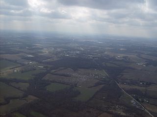
Perry County is a county located in the U.S. state of Ohio. As of the 2020 census, the population was 35,408. Its county seat is New Lexington. It was established on March 1, 1818, from parts of Fairfield, Washington and Muskingum counties. The county is named for Oliver Hazard Perry, a hero of the War of 1812. Perry County is included in the Columbus, OH Metropolitan Statistical Area. One of the poorest counties in the state, this is where the lawsuit challenging Ohio's school funding system, DeRolph v. State, began.

<span class="mw-page-title-main">Ashland County, Ohio</span> County in Ohio, United States

Ashland County is a county located in the northeastern portion of the U.S. state of Ohio. As of the 2020 census, the population was 52,447. Its county seat and largest city is Ashland. The county is named for "Ashland", the home of Senator Henry Clay near Lexington, Kentucky. It was formed in 1846 from parts of Huron, Lorain, Richland and Wayne Counties.

<span class="mw-page-title-main">Glouster, Ohio</span> Village in Ohio, United States

Glouster is a village in Trimble Township, Athens County, Ohio, United States. The population was 1,659 at the 2020 census. It is close to Burr Oak State Park.

<span class="mw-page-title-main">Aberdeen, Ohio</span> Village in Ohio, United States

Aberdeen is a village in Huntington Township, Brown County, Ohio, United States, along the Ohio River 50 miles (80 km) southeast of Cincinnati. The population was 1,515 at the 2020 census.

<span class="mw-page-title-main">Leesville, Ohio</span> Village in Ohio, United States

Leesville is a village in southwestern Carroll County, Ohio, United States. The population was 127 at the 2020 census. It is part of the Canton–Massillon metropolitan area.

<span class="mw-page-title-main">Warsaw, Ohio</span> Village in Ohio, United States

Warsaw is a village in Coshocton County, Ohio, United States, along the Walhonding River. The population was 624 at the 2020 census.

<span class="mw-page-title-main">Newtown, Ohio</span> Village in Ohio, United States

Newtown is a village in southeastern Hamilton County, Ohio, United States, near Cincinnati. The population was 2,702 at the 2020 census. Newtown was settled in 1792 and incorporated as a village in 1901.

<span class="mw-page-title-main">Perry, Ohio</span> Village in Ohio, United States

Perry is a village in Lake County, Ohio, United States. The population was 1,602 at the 2020 census.

<span class="mw-page-title-main">Montezuma, Ohio</span> Village in Ohio, United States

Montezuma is a village in Mercer County, Ohio, United States. The population was 152 at the 2020 census.

<span class="mw-page-title-main">Paulding, Ohio</span> Village in Ohio, United States

Paulding is a village in and the county seat of Paulding County, Ohio, United States. It is located predominantly in Paulding Township about 64 miles (103 km) southwest of Toledo. The population was 3,555 at the 2020 census.

<span class="mw-page-title-main">Corning, Ohio</span> Village in Ohio, United States

Corning is a village in Perry County, Ohio, United States. The population was 488 at the 2020 census.

<span class="mw-page-title-main">Glenford, Ohio</span> Village in Ohio, United States

Glenford is a village in Perry County, Ohio, United States. The population was 165 at the 2020 census.

<span class="mw-page-title-main">Junction City, Ohio</span> Village in Ohio, United States

Junction City is a village in Perry County, Ohio, United States. The population was 721 at the 2020 census.

<span class="mw-page-title-main">New Lexington, Ohio</span> Village in Ohio, United States

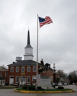
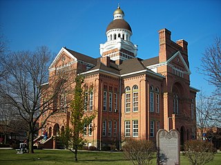
New Lexington is a village in and the county seat of Perry County, Ohio, United States, 21 miles (34 km) southwest of Zanesville and 45 miles (72 km) miles southeast of Columbus. The population was 4,435 at the 2020 census.

<span class="mw-page-title-main">Rendville, Ohio</span> Village in Ohio, United States

Rendville is a village in Perry County, Ohio, United States. It is an old mining town in southeastern Appalachian Ohio. The population was 28 at the 2020 census, making it the smallest incorporated community in Ohio.

<span class="mw-page-title-main">Shawnee, Perry County, Ohio</span> Village in Ohio, United States

Shawnee is a village in Perry County, Ohio, United States. The population was 505 at the 2020 census. It is 9 miles (14 km) south of the county seat of New Lexington.

<span class="mw-page-title-main">Thornville, Ohio</span> Village in Ohio, United States

Thornville is a village in Perry County, Ohio, United States. It is 20 miles (32 km) north of the county seat of New Lexington. The village had a population of 1,087 as of the 2020 census.

<span class="mw-page-title-main">Bainbridge, Ross County, Ohio</span> Village in Ohio, United States

Bainbridge is a village in Ross County, Ohio, United States, along Paint Creek. The population was 765 at the 2020 census.

<span class="mw-page-title-main">Bradner, Ohio</span> Village in Ohio, United States

Bradner is a village in Wood County, Ohio, United States. The population was 971 at the 2020 census.

<span class="mw-page-title-main">Ottawa County, Ohio</span> County in Ohio, United States

Ottawa County is a county located in the northwestern part of the U.S. state of Ohio. As of the 2020 census, the population was 40,364. Its county seat is Port Clinton. The county is named either for the Ottawa (Odawa) Indigenous peoples who lived there, or for an Indigenous word meaning "trader".

References

  1. "ArcGIS REST Services Directory". United States Census Bureau. Retrieved September 20, 2022.
  2. 1 2 U.S. Geological Survey Geographic Names Information System: Somerset, Ohio
  3. 1 2 "U.S. Census website". United States Census Bureau . Retrieved January 31, 2008.
  4. Owen, Lorrie K., ed. Dictionary of Ohio Historic Places. Vol. 2. St. Clair Shores: Somerset, 1999, 1138.
  5. 1 2 Martzolff, Clement Luther. History of Perry County, Ohio . New Lexington: Ward and Weiland, 1902.
  6. Thrane, Susan W. County Courthouses of Ohio. Bloomington: Indiana UP, 2000, 119.
  7. Borchers, Perry E. Written Historical and Descriptive Data: Old Perry County Court House [ permanent dead link ], Historic American Buildings Survey, 1959-06, 1. Accessed November 24, 2012.
  8. "US Gazetteer files 2010". United States Census Bureau. Archived from the original on July 2, 2012. Retrieved January 6, 2013.
  9. "Census of Population and Housing". Census.gov. Retrieved June 4, 2015.
  10. "U.S. Census website". United States Census Bureau . Retrieved January 6, 2013.
  11. "Our schools". Northern Local School District. Retrieved March 3, 2018.
  12. "Hours and locations". Perry County District Library. Retrieved March 3, 2018.