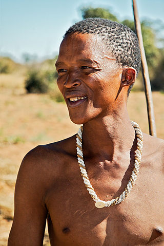
KhoisanKOY-sahn, or Khoe-Sān, is a catch-all term for the indigenous peoples of Southern Africa who traditionally speak non-Bantu languages, combining the Khoekhoen and the Sān peoples. Khoisan populations traditionally speak click languages and are considered to be the historical communities throughout Southern Africa, remaining predominant until European colonisation in areas climatically unfavorable to Bantu (sorghum-based) agriculture, such as the Cape region, through to Namibia, where Khoekhoe populations of Nama and Damara people are prevalent groups, and Botswana. Considerable mingling with Bantu-speaking groups is evidenced by prevalence of click phonemes in many especially Xhosa Southern African Bantu languages.
Hessequa Municipality, known before 24 June 2005 as Langeberg Municipality, is a local municipality within the Garden Route District Municipality, in the Western Cape province of South Africa. It is flanked by the lower Breede River to the west and the Gourits River to the east. As of 2022, the population was 71,918. Its municipality code is WC042. The name Hessequa, meaning "people of the trees", refers to the indigenous Khoikhoi people.
Theewaterskloof Municipality is a local municipality located within the Overberg District Municipality, in the Western Cape province of South Africa. As of 2022, the population was 139,563. Its municipality code is WC031. The enormous Theewaterskloof Dam, which provides water for Cape Town and the surrounding areas, is located in the municipality.

The Breede River, also known as Breë River, is a river in the Western Cape Province of South Africa. Travelling inland north from the city of Cape Town, the river runs in a west to east direction. The surrounding western mountains formed the first continental divide experienced by European settlers in the 18th century. The Titus River and Dwars River become the Breë River.

Stilbaai, also known as the Bay of Sleeping Beauty, is a town along the southern coast of South Africa about four hours by car from Cape Town. It is part of the Hessequa Local Municipality in the Western Cape province.
The !Khukaǁgamma or Sundays River is a river in the Eastern Cape Province of South Africa. It is said to be the fastest flowing river in the country. The Inqua Khoi people, who historically were the wealthiest group in Southern Africa, originally named this river !Khukaǁgamma, 'the waters with the spirit of abundance' because the river's banks are always green and grassy despite the arid terrain that it runs through.

The area known today as Cape Town has no written history before it was first mentioned by Portuguese explorer Bartholomeu Dias in 1488. The German anthropologist Theophilus Hahn recorded that the original name of the area was '||Hui !Gais' – a toponym in the indigenous Khoi language meaning "where clouds gather."
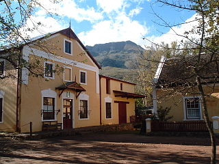
Genadendal is a town in the Western Cape province of South Africa, built on the site of the oldest mission station in the country. It was originally known as Baviaanskloof, but was renamed Genadendal in 1806. Genadendal was the place of the first Teachers' Training College in South Africa, founded in 1838.

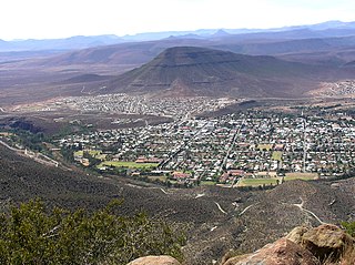
Riversdale is a town located along the N2 highway, within the Hessequa region between Cape Town and George on the Agulhas Coastal Plain of the southern Western Cape province of South Africa. It is an agricultural service oriented town, being a hub for shopping and other services for surrounding farming communities, smaller towns, and coastal resorts, like Witsand and Stilbaai. It is located beneath the imposing Langeberg Mountains to the north, with Sleeping Beauty Mountain Peak overlooking the town. The town is home to the second largest collection of Thomas Bowler paintings within South Africa and is also the only town in the country, in which you would find a Ukrainian Museum of Culture. Riversdale links with the Klein Karoo, via the tarred Garcia's Mountain Pass, which offers traditional Karoo landscapes and wide open spaces for motorcyclists.

The Riviersonderend Mountains are a mountain range in the Cape Fold Belt of the Western Cape province of South Africa. They run east to west from Riviersonderend to Villiersdorp, separating the Breede River Valley from the Overberg region. They are composed of Table Mountain Sandstone and attain a maximum height near McGregor and Riviersonderend as Pilaarkop. The ranges are rich in fynbos flora and experience a typical Mediterranean climate.

Kou-Kamma Municipality is a local municipality in South Africa. It is situated in the southwest corner of the Sarah Baartman District Municipality along the Indian Ocean coastline, in the southwestern sector of South Africa's Eastern Cape province. To the west lies the Western Cape. Kou-Kamma also borders the Dr Beyers Naudé Local Municipality in the north and the Kouga Local Municipality to the east. The geographical area of the municipality is 12,540 square kilometres.

Kareedouw is a town in the Eastern Cape province of South Africa. It is the administrative centre for the Kou-Kamma Municipality in the Sarah Baartman District of the Eastern Cape.
The Western Cape Water Supply System (WCWSS) is a complex water supply system in the Western Cape region of South Africa, comprising an inter-linked system of six main dams, pipelines, tunnels and distribution networks, and a number of minor dams, some owned and operated by the Department of Water and Sanitation and some by the City of Cape Town.
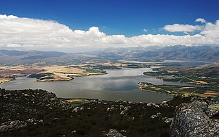
Theewaterskloof Dam is an earth-fill type dam located on the Sonderend River near Villiersdorp, Western Cape, South Africa. Administratively it is located within Theewaterskloof Local Municipality. It was established in 1978 and is the largest dam in the Western Cape Water Supply System with a capacity of 480 million cubic metres, about 41% of the water storage capacity available to Cape Town, which has a population of over 4 million people. The dam mainly serves for municipal and industrial use as well as for irrigation purposes. The hazard potential of the dam has been ranked high (3).
The Touws River is a river in the Western Cape province of South Africa. It is a tributary of the Groot River, part of the Gourits River basin. A notable resident of the town is Margaret Maritz who, as of 2022, aged 116, was regarded as one of the oldest people in South Africa.

The Kouga River originates near Uniondale, Eastern Cape, South Africa, and flows eastward, where it joins the Groot River to form the Gamtoos just past the Kouga Dam. Its main tributary is the Baviaanskloof River, which joins its left bank before the dam.

Molteno Dam is a small but historic dam, on the lower slopes of Table Mountain in Western Cape, South Africa. Still in service, it was established in 1877 and is now located in the suburb of Oranjezicht, Cape Town.
Riviersonderend is a village in the Overberg region of the Western Cape, South Africa, about 140 kilometres (87 mi) east of Cape Town. It is located on a loop of the Sonderend River, from which it takes its name. In the census of 2011 it was recorded as having a population of 5,245. The N2 national road passes through Riviersonderend, forming its main street; it is 161 kilometres (100 mi) by road from central Cape Town.

The Boland is a region of the Western Cape province of South Africa, situated to the northeast of Cape Town in the middle and upper courses of the Berg and Breede Rivers, around the Boland Mountains of the central Cape Fold Belt. It is sometimes also referred to as the Cape Winelands because it is the primary region for the making of Western Cape wine.

