Armadale is a village near the southern end of the Sleat peninsula on the Isle of Skye, in the Highland council area of Scotland. Like most of Sleat, but unlike most of Skye, the area is fairly fertile, and though there are hills, most do not reach a great height. It looks out over the Sound of Sleat, to Morar and Mallaig.
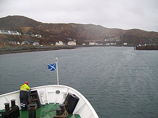
Mallaig is a port in Lochaber, on the west coast of the Highlands of Scotland. The local railway station, Mallaig, is the terminus of the West Highland railway line and the town is linked to Fort William by the A830 road – the "Road to the Isles".

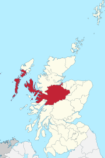
Sleat is a peninsula and civil parish on the island of Skye in the Highland council area of Scotland, known as "the garden of Skye". It is the home of the clan MacDonald of Sleat. The name comes from the Scottish Gaelic Slèite, which in turn comes from Old Norse sléttr, which well describes Sleat when considered in the surrounding context of the mainland, Skye and Rùm mountains that dominate the horizon all about Sleat.

The Skye Bridge is a road bridge over Loch Alsh, Scotland, connecting the Isle of Skye to the island of Eilean Bàn. The name is also used for the whole Skye Crossing, which further connects Eilean Bàn to the mainland across the Carrich Viaduct. The crossing forms part of the A87.

Kyle of Lochalsh is a village in the historic county of Ross-shire on the northwest coast of Scotland, located around 55 miles (90 km) west-southwest of Inverness. It is located on the Lochalsh peninsula, at the entrance to Loch Alsh, opposite the village of Kyleakin on the Isle of Skye. A ferry used to connect the two villages until it was replaced by the Skye Bridge, about a mile (2 km) to the west, in 1995.
Glenelg (Scottish Gaelic: Glinn Eilg, also Gleann Eilg is a scattered community area and civil parish in the Lochalsh area of Highland in western Scotland. Despite the local government reorganisation the area is considered by many still to be in Inverness-shire, the boundary with Ross-shire being at the top of Mam Ratagan the single-track road entry into Glenelg.

MV Lord of the Isles is one of the larger Caledonian Maritime Assets Limited ferries, run by Caledonian MacBrayne and largely operating from Mallaig on the west of Scotland. Built in Port Glasgow, she is the most-travelled vessel in the CalMac fleet.

Loch Hourn is a sea loch which separates the peninsulas of Glenelg to the north and Knoydart to the south, on the west coast of Scotland.
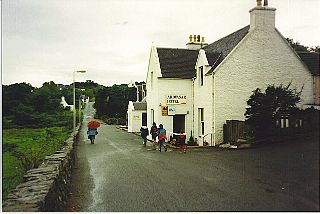
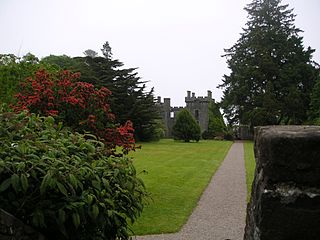
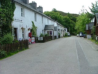
Ardvasar is a village near the southern end of the Sleat peninsula, on the Isle of Skye in Scotland. It is just to the south of the village of Armadale, where a ferry crosses to Mallaig. Nearby attractions include Armadale Castle and the Museum of the Isles.

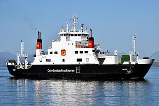
MV Loch Fyne is a Caledonian MacBrayne car ferry, owned by Caledonian Maritime Assets Limited, built in 1991 for the Isle of Skye crossing and now operating the Mallaig to Armadale route in western Scotland.

Beinn Sgritheall or Beinn an Sgrithill, also anglicized Ben Sgriol, is the highest mountain on the Glenelg peninsula in the Northwest Highlands of Scotland. It is a Munro with a height of 974 metres (3,196 ft). The main approach is via Arnisdale on the shores of Loch Hourn or via Gleann Beag to the north, with its well-known brochs. The view from the summit was described by Sir Hugh Munro, a founder member of the Scottish Mountaineering Club, as "perhaps the most beautiful I have seen in Scotland".

Loch Nevis is a sea loch in Lochaber on the west coast of Scotland.

Loch Alsh is a sea inlet between the isle of Skye in the Inner Hebrides and the Northwest Highlands of Scotland. The name is also used to describe the surrounding country and the feudal holdings around the loch. The area is rich in history, and is increasingly popular with tourists.

The Isle of Skye, or simply Skye, is the largest and northernmost of the major islands in the Inner Hebrides of Scotland. The island's peninsulas radiate from a mountainous hub dominated by the Cuillin, the rocky slopes of which provide some of the most dramatic mountain scenery in the country. Although Sgitheanach has been suggested to describe a winged shape, no definitive agreement exists as to the name's origins.
Inverness-shire is a historic county, registration county and lieutenancy area of Scotland. Covering much of the Highlands and Outer Hebrides, it is Scotland's largest county, though one of the smallest in population, with 67,733 people or 1.34% of the Scottish population.
MV Coruisk is a Caledonian Maritime Assets Limited ferry built in 2003, operated by Scottish ferry operator Caledonian MacBrayne and serving the west coast of Scotland.

Minginish is a peninsula on the Isle of Skye in Scotland. It is situated on the west coast of the island and runs from Loch Scavaig in the south, along the western coast of Skye to Loch Bracadale in the north west, to Loch Harport in the north east, and Glen Sligachan in the south east. It includes most of the peaks of the Cuillin hills including Sgurr Alasdair, the highest point on the island at 992 metres (3,255 ft). The island of Soay lies offshore across the Soay Sound, with the Small Isles further south across the Cuillin Sound.

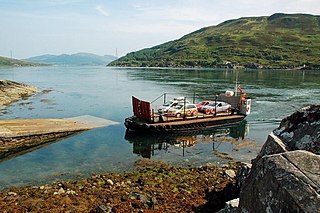
MV Glenachulish is a ferry operating a summer service between Glenelg, on the Scottish mainland, and Kylerhea, on the Isle of Skye. Built in 1969, she is the last manually operated steel turntable ferry in the world.

Lochalsh is a district of mainland Scotland that is currently part of the Highland council area. The Lochalsh district covers all of the mainland either side of Loch Alsh - and of Loch Duich - between Loch Carron and Loch Hourn, ie. from Stromeferry in the north on Loch Carron down to Corran on Loch Hourn and as (south-)west as Kintail. It was sometimes more narrowly defined as just being the hilly peninsula that lies between Loch Carron and Loch Alsh. The main settlement is Kyle of Lochalsh, located at the entrance to Loch Alsh, opposite the village of Kyleakin on the adjacent island of Skye. A ferry used to connect the two settlements but was replaced by the Skye Bridge in 1995.
Kyle Rhea is a strait of water in the Highland area of Scotland. It runs from the Inner Seas off the West Coast of Scotland in the southwest to Loch Alsh in the northeast, separating the Isle of Skye from Inverness-shire on the Scottish mainland. It gave its name to Kylerhea, a village on its western shore.
