South Berwick, Maine

Last updated

South Berwick, Maine
Main Street & Central Square, South Berwick, ME.jpg
Central Square c.1910
Nickname: 
The Berwicks
USA Maine location map.svg
Red pog.svg
South Berwick
Location within the state of Maine
Coordinates: 43°14′04″N70°49′30″W / 43.23444°N 70.82500°W / 43.23444; -70.82500
CountryUnited States
State Maine
County York
Settled1631
Incorporated1814
Villages South Berwick
Emerys Bridge
Great Works
Jewett
Government
  Type Town Council
   Town Manager Tim Pellerin
  Town CouncilChair: Mallory Cook
John C. Kareckas
John James
Jessica Cyr
Jeff Minihan
Area
[1]
  Total32.64 sq mi (84.54 km2)
  Land32.13 sq mi (83.22 km2)
  Water0.51 sq mi (1.32 km2)
Elevation
43 ft (31 m)
Population
 (2020) [2]
  Total7,467
  Density232/sq mi (89.7/km2)
Time zone UTC-5 (Eastern)
  Summer (DST) UTC-4 (Eastern)
ZIP code
03908
Area code 207
FIPS code 23-70030
GNIS feature ID0582732
Website www.southberwickmaine.org

South Berwick is a town in York County, Maine, United States. The population was 7,467 at the 2020 census. [3] South Berwick is home to Berwick Academy, a private, co-educational university-preparatory day school founded in 1791.

Contents

The town was set off from Berwick in 1814, followed by North Berwick in 1831. It is part of the PortlandSouth PortlandBiddeford, Maine metropolitan statistical area. The primary village in the town is the South Berwick census-designated place.

History

The area was called Newichawannock by the Abenaki Indians, meaning "river with many falls," a reference to the Salmon Falls River. It was first settled by Europeans about 1631 as a part of Kittery known as Kittery North Parish. Near the confluence with the Great Works River, Ambrose Gibbons built the Great House at Newichawannock, a palisaded trading post, to exchange goods with the Indians. [4]

In 1634, William Chadbourne, James Wall, and John Goddard arrived from England aboard the ship Pied Cow to build a sawmill and gristmill at Assabumbadoc Falls. The first houses built in South Berwick were built by Chadbourne and Wall. Chadbourne's house was in the northwesterly angle of Brattle Street and Dow Highway (Rt. 236). [5] [6] [7] Richard Leader, an engineer, rebuilt the sawmill in 1651 to handle up to 20 saws. The factory became known as the "Great mill workes," from which the Great Works River derives its name. It was run by 25 Scottish prisoners of war captured by Oliver Cromwell's forces at the 1650 Battle of Dunbar and transported aboard the Unity to North America. They were sold as indentured servants whose labor would earn them freedom. The community was dubbed the Parish of Unity after the ship. [4]

The village was attacked in 1675 during King Philip's War, then raided again in 1690–1691 during King William's War by Indians under the command of officers from New France, who burned the Parish of Unity to the ground. It was abandoned, but resettled in 1703 under its Abenaki name, Newichawannock. The Massachusetts General Court incorporated it in 1713 as Berwick, the 9th oldest town in Maine. It was named after Berwick-upon-Tweed, a town of mixed allegiances on the Anglo-Scottish border. What evolved into today's Berwick Academy opened in 1791. On February 12, 1814, South Berwick was set off and incorporated. [8]

During the 19th century, various mills were erected at the rivers to use their water power. At the head of navigation, Quampheagan Falls on the Salmon Falls River became the site of the Portsmouth Manufacturing Company. Established in 1831, the cotton textile mill had 7000 spindles and 216 looms, which by 1868 produced 2 million yards of sheeting per year. [8] The mill closed in 1893, and most of its brick buildings were razed about 1917, but the Greek Revival counting house is now the Old Berwick Historical Society Museum. South Berwick also made woolens, shoes, plows, and cultivators, as well as sawn and planed lumber. The town was noted for its apple orchards. Some inhabitants worked across the bridge in Rollinsford, New Hampshire at the Salmon Falls Manufacturing Company, which closed in 1927. [9] The village center was listed on the National Register of Historic Places in 2010.

In 1901, local author Sarah Orne Jewett set her historical romance The Tory Lover at the Hamilton House in South Berwick. Built about 1785, the Federal style mansion is now a museum operated by Historic New England, which also owns the Sarah Orne Jewett House, built in 1774 overlooking Central Square.

Geography

According to the United States Census Bureau, the town has a total area of 32.64 square miles (84.54 km2), of which 32.13 square miles (83.22 km2) is land and 0.51 square miles (1.32 km2) water. [1] Located beside the New Hampshire border, South Berwick is drained by the Great Works River and Salmon Falls River. Welch Hill, elevation 370 feet (112.8 m) above sea level, is the town's highest point. The lowest elevation, which is sea level, is located along the Salmon Falls River, from the small hydroelectric dam next to the New Hampshire Route 4 bridge, south to the town's border with Eliot.

Demographics

Historical population
CensusPop.Note
1820 1,475
1830 1,5776.9%
1840 2,31446.7%
1850 2,59212.0%
1860 2,6241.2%
1870 2,510−4.3%
1880 2,6776.7%
1890 3,43428.3%
1900 3,188−7.2%
1910 2,935−7.9%
1920 2,9550.7%
1930 2,650−10.3%
1940 2,546−3.9%
1950 2,6463.9%
1960 3,11217.6%
1970 3,48812.1%
1980 4,04616.0%
1990 5,87745.3%
2000 6,67113.5%
2010 7,2208.2%
2020 7,4673.4%
U.S. Decennial Census [10]

2010 census

As of the census [2] of 2010, there were 7,220 people, 2,729 households, and 1,979 families residing in the town. The population density was 224.7 inhabitants per square mile (86.8/km2). There were 2,911 housing units at an average density of 90.6 per square mile (35.0/km2). The racial makeup of the town was 97.5% White, 0.2% African American, 0.2% Native American, 0.8% Asian, 0.2% from other races, and 1.1% from two or more races. Hispanic or Latino of any race were 0.8% of the population.

There were 2,729 households, of which 38.3% had children under the age of 18 living with them, 59.1% were married couples living together, 9.4% had a female householder with no husband present, 4.0% had a male householder with no wife present, and 27.5% were non-families. 21.3% of all households were made up of individuals, and 7.9% had someone living alone who was 65 years of age or older. The average household size was 2.64 and the average family size was 3.09.

The median age in the town was 40.5 years. 26.6% of residents were under the age of 18; 7.3% were between the ages of 18 and 24; 23.5% were from 25 to 44; 32.4% were from 45 to 64; and 10.1% were 65 years of age or older. The gender makeup of the town was 49.4% male and 50.6% female.

2000 census

As of the census [11] of 2000, there were 6,671 people, 2,403 households, and 1,847 families residing in the town. The population density was 207.5 inhabitants per square mile (80.1/km2). There were 2,488 housing units at an average density of 77.4 per square mile (29.9/km2). The racial makeup of the town was 97.63% White, 0.30% African American, 0.30% Native American, 0.66% Asian, 0.27% from other races, and 0.84% from two or more races. Hispanic or Latino of any race were 0.67% of the population.

There were 2,403 households, out of which 44.0% had children under the age of 18 living with them, 64.3% were married couples living together, 8.7% had a female householder with no husband present, and 23.1% were non-families. 18.4% of all households were made up of individuals, and 6.7% had someone living alone who was 65 years of age or older. The average household size was 2.76 and the average family size was 3.17.

In the town, the population was spread out, with 30.4% under the age of 18, 5.4% from 18 to 24, 32.8% from 25 to 44, 23.0% from 45 to 64, and 8.4% who were 65 years of age or older. The median age was 36 years. For every 100 females, there were 97.4 males. For every 100 females age 18 and over, there were 93.0 males.

The median income for a household in the town was $53,201, and the median income for a family was $59,330. Males had a median income of $40,107 versus $25,729 for females. The per capita income for the town was $21,118. About 2.8% of families and 2.9% of the population were below the poverty line, including 1.3% of those under age 18 and 7.1% of those age 65 or over.

Strawberry Festival

Since 1976, South Berwick has hosted a Strawberry Festival on the last Saturday in June. Originally organized to celebrate the United States Bicentennial, its popularity has convinced the festival's organizers to hold it each year since. It includes shops, food, games and rides for children and trolley rides. The festival is held on the grounds of Central School, the primary elementary school for the town of South Berwick. [12]

Sites of interest

Notable people

Sister cities

Related Research Articles

<span class="mw-page-title-main">York County, Maine</span> County in Maine, United States

York County is the southwesternmost county in the U.S. state of Maine, along the state of New Hampshire's eastern border. It is divided from Strafford County, New Hampshire, by the Salmon Falls River, and the connected tidal estuary—the Piscataqua River. York County was permanently established in 1639. It is the state's oldest county and one of the oldest in the United States. Several of Maine's earliest colonial settlements are found in the county. As of the 2020 census, its population was 211,972, making it Maine's second-most populous county. Its county seat is Alfred. York County is part of the Portland–South Portland, Maine Metropolitan Statistical Area.

<span class="mw-page-title-main">Solon, Maine</span> Town in the state of Maine, United States

Solon is a town in Somerset County, Maine, United States. The population was 978 at the 2020 census.

<span class="mw-page-title-main">Acton, Maine</span> Town in the state of Maine, United States

Acton is a town in York County, Maine, United States. The population was 2,671 at the 2020 census. It includes the villages of Acton, Miller Corner and South Acton. The town is home to the Acton Fairground, which holds the Acton Fair every late summer. It is part of the Portland–South Portland–Biddeford, Maine metropolitan statistical area.

<span class="mw-page-title-main">Buxton, Maine</span> Town in Maine, United States

Buxton is a town in York County, Maine, United States. It is part of the Portland metropolitan area. The population was 8,376 at the 2020 census. Buxton includes the villages of Salmon Falls/Tory Hill, Chicopee, Groveville, Bar Mills, West Buxton, and Buxton Center. The old town Common is east of Union Falls, which is the location of Skelton Dam, operated by Central Maine Power, and near historic location of the original settlement at Pleasant Point.

<span class="mw-page-title-main">Dayton, Maine</span> Town in the state of Maine, United States

Dayton is a town in York County, Maine, United States, the town is located near the Saco-Biddeford city area. Dayton borders Biddeford by land, and borders Saco on the Saco River. It is also part of the Portland–South Portland–Biddeford, Maine metropolitan statistical area. The population was 2,129 at the 2020 census. Dayton is one of the smallest towns in York County.

<span class="mw-page-title-main">Eliot, Maine</span> Town in Maine, United States

Eliot is a town in York County, Maine, United States. Originally settled in 1623, it was formerly a part of Kittery, Maine, to its east. After Kittery, it is the next most southern town in the state of Maine, lying on the Piscataqua River across from Portsmouth and Newington, New Hampshire. The population was 6,717 at the 2020 census. It is part of the Portland–South Portland–Biddeford, Maine metropolitan statistical area.

<span class="mw-page-title-main">Hollis, Maine</span> Town in the state of Maine, United States

Hollis is a town in York County, Maine, United States. The population was 4,745 at the 2020 census. Hollis is a rural bedroom community of Portland and is part of the Portland–South Portland–Biddeford, Maine metropolitan statistical area.

<span class="mw-page-title-main">Kittery Point, Maine</span> Census-designated place in Maine, United States

Kittery Point is a census-designated place (CDP) in the town of Kittery, York County, Maine, United States. First settled in 1623, Kittery Point traces its history to the first seafarers who colonized the shore of what became Massachusetts Bay Colony and later the State of Maine. Located beside the Atlantic Ocean, it is home to Fort McClary State Historic Site, and Fort Foster Park on Gerrish Island. Cutts Island is home to Seapoint Beach and the Brave Boat Harbor Division of the Rachel Carson National Wildlife Refuge.

<span class="mw-page-title-main">Lebanon, Maine</span> Town in Maine, United States

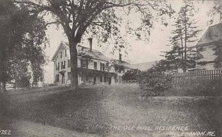
Lebanon is a town in York County, Maine, United States. The population was 6,469 at the 2020 census. Lebanon includes the villages of Center Lebanon, West Lebanon, North Lebanon, South Lebanon, and East Lebanon. It is the westernmost town in Maine. Lebanon is part of the Portland–South Portland–Biddeford, Maine metropolitan statistical area.

<span class="mw-page-title-main">Limerick, Maine</span> Town in Maine, United States

Limerick is a town in York County, Maine, United States. It is part of the Portland–South Portland–Biddeford, Maine metropolitan statistical area. The population was 3,188 at the 2020 census.

<span class="mw-page-title-main">Newfield, Maine</span> Town in the state of Maine, United States

Newfield is a town in York County, Maine, United States. The population was 1,648 at the 2020 census. The town is part of the Portland–South Portland–Biddeford metropolitan statistical area.

<span class="mw-page-title-main">Parsonsfield, Maine</span> Town in the state of Maine, United States

Parsonsfield is a town in York County, Maine, United States. The population was just 1,791 at the 2020 census. Parsonsfield includes the villages of Kezar Falls, Parsonsfield, and North, East and South Parsonsfield. It is part of the Portland–South Portland–Biddeford, Maine metropolitan statistical area.

<span class="mw-page-title-main">Wakefield, New Hampshire</span> Town in New Hampshire, United States

Wakefield is a town in Carroll County, New Hampshire, United States. The population was 5,201 at the 2020 census. The town includes the villages of Wakefield Corner, East Wakefield, North Wakefield, Sanbornville, Union, Woodman and Province Lake. Wakefield Corner, popular with tourists, is a picturesque hilltop village of antique buildings. The state of Maine is on the eastern border of Wakefield.

<span class="mw-page-title-main">Rollinsford, New Hampshire</span> Town in New Hampshire, United States

Rollinsford is a town in Strafford County, New Hampshire, United States. The population was 2,597 at the 2020 census. The main village in town was once known as "Salmon Falls Village".

<span class="mw-page-title-main">Somersworth, New Hampshire</span> City in New Hampshire, United States

Somersworth is a city in Strafford County, New Hampshire, United States. The population was 11,855 at the 2020 census. Somersworth has the smallest area and third-lowest population of New Hampshire's 13 cities.

<span class="mw-page-title-main">Kittery, Maine</span> Town in the state of Maine, United States

Kittery is a town in York County, Maine, United States. Home to the Portsmouth Naval Shipyard on Seavey's Island, Kittery includes Badger's Island, the seaside district of Kittery Point, and part of the Isles of Shoals. The southernmost town in the state, it is a tourist destination known for its many outlet stores.

<span class="mw-page-title-main">North Berwick (CDP), Maine</span> Census-designated place in Maine, United States

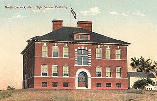
North Berwick is a census-designated place (CDP) consisting of the primary settlement in the town of North Berwick in York County, Maine, United States. The population was 1,615 at the 2010 census, out of a total town population of 4,576. It is part of the Portland–South Portland–Biddeford, Maine Metropolitan Statistical Area.

<span class="mw-page-title-main">North Berwick, Maine</span> Town in Maine, United States

North Berwick is a town in York County, Maine, United States. The town was set off from Berwick in 1831, following South Berwick in 1814.

<span class="mw-page-title-main">Berwick, Maine</span> Town in the state of Maine, United States

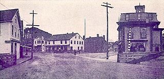
Berwick is a town in York County, Maine, United States, situated in the southern part of the state beside the Salmon Falls River.

<span class="mw-page-title-main">Berwick (CDP), Maine</span> Census-designated place in Maine, United States

Berwick is a census-designated place (CDP) in the town of Berwick in York County, Maine, United States. The population was 2,187 at the 2010 census, out of a total of 7,246 in the entire town. It is part of the Portland–South Portland–Biddeford, Maine Metropolitan Statistical Area.

References

  1. 1 2 "US Gazetteer files 2010". United States Census Bureau . Retrieved December 16, 2012.
  2. 1 2 "U.S. Census website". United States Census Bureau . Retrieved December 16, 2012.
  3. "Census - Geography Profile: South Berwick town, York County, Maine" . Retrieved January 12, 2022.
  4. 1 2 Coolidge, Austin J.; John B. Mansfield (1859). A History and Description of New England. Boston, Massachusetts: A.J. Coolidge. pp.  53–54. coolidge mansfield history description new england 1859.
  5. Stager, Helen and Stager, Evelyn. A Family Odyssey: The Ancestors and Descendants of Joseph Harrison and Ada Belle (Marsh) Stager, p. 269, Nicollet Press, Inc., Pipestone, MN, 1983.
  6. Stackpole, Everett S. Old Kittery and Her Families, Scholar's Choice, 2015.
  7. Spencer, Wilbur D. Pioneers on Maine Rivers, Genealogical Publishing Co., Inc., 1973.
  8. 1 2 Varney, George J. (1886), Gazetteer of the state of Maine. South Berwick, Boston: Russell
  9. History of South Berwick, Maine (1926)
  10. "Census of Population and Housing". Census.gov. Retrieved June 4, 2015.
  11. "U.S. Census website". United States Census Bureau . Retrieved January 31, 2008.
  12. "South Berwick Strawberry Festival". South Berwick Strawberry Festival. Retrieved March 11, 2011.

43°14′04″N70°48′34″W / 43.23444°N 70.80944°W / 43.23444; -70.80944