
The Burnett River is a river located in the Wide Bay–Burnett and Central Queensland regions of Queensland, Australia.

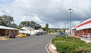
Kingaroy is a rural town and locality in the South Burnett Region, Queensland, Australia. It is approximately 210 kilometres (130 mi) or about 2½ hours drive north-west of the state capital Brisbane. The town is situated on the junction of the D'Aguilar and the Bunya Highways. As at June 2018, Kingaroy had a population of 10,398 with the 2016 census showing a median age of 37.

Nanango is a town and locality in the South Burnett Region of Queensland, Australia. In the 2016 census, Nanango had a population of 3,599 people.
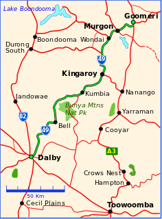
The Bunya Highway is a state highway of Queensland, Australia. It is a relatively short road, running approximately 173 kilometres in a south-westerly direction from Goomeri to Dalby. The highway connects the Warrego and Burnett Highways.

The Shire of Wondai was a local government area located in the South Burnett region of Queensland, Australia, about 140 kilometres (87 mi) northwest of the capital, Brisbane. The shire covered an area of 3,577.6 square kilometres (1,381.3 sq mi), and existed as a local government entity from 1910 until 2008, when it amalgamated with several other councils in the South Burnett area to form the South Burnett Region.

Murgon is a rural town and locality in the South Burnett Region, Queensland, Australia. It is situated on the Bunya Highway 270 kilometres (170 mi) north-west of the state capital, Brisbane. At the 2016 Australian Census, the town recorded a population of 2,378.

Wondai is a rural town and locality in the South Burnett Region, Queensland, Australia. In the 2016 census, Wondai had a population of 1,973 people.
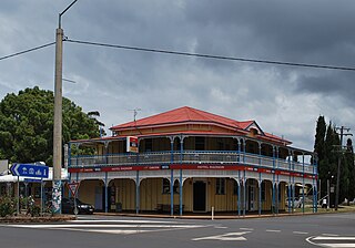
Proston is a rural town and locality in the South Burnett Region, Queensland, Australia. In the 2016 census, Proston had a population of 379 people.
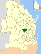
The Shire of Kingaroy was a local government area in the South Burnett region of Queensland, Australia, about 100 kilometres (62 mi) northwest of the capital, Brisbane. The shire covered an area of 2,420.3 square kilometres (934.5 sq mi), and existed as a local government entity from 1912 until 2008, when it amalgamated with several other councils in the South Burnett area to become the South Burnett Regional Council.
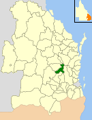
The Shire of Nanango was a local government area located in the South Burnett region of Queensland, Australia, about 100 kilometres (62 mi) northwest of the capital, Brisbane. The Shire covered an area of 1,738.4 square kilometres (671.2 sq mi), and existed as a local government entity from 1879 until 2008, when it amalgamated with several other councils in the South Burnett area to become the South Burnett Regional Council.

The Shire of Murgon was a local government area in the South Burnett region of Queensland, Australia. The shire covered an area of 664.7 square kilometres (256.6 sq mi), and existed as a local government entity from 1914 until 2008, when it amalgamated with several other councils in the South Burnett area to become the South Burnett Regional Council.
Blackbutt is a rural town and locality in the South Burnett Region, Queensland, Australia. In the 2016 census, Blackbutt had a population of 836 people.

The South Burnett Region is a local government area in the South Burnett district of Queensland, Australia.

The Bjelke-Petersen Dam is a dam in Moffatdale near Cherbourg in the South Burnett Region, Queensland, Australia. The dam impounds Barker Creek and creates Lake Barambah. It is named after the Queensland Premier Joh Bjelke-Petersen. It is operated by Sunwater.

Wooroolin is a town and a locality in the South Burnett Region, Queensland, Australia. In the 2016 census, Wooroolin had a population of 315 people.

The Nanango railway line was a narrow-gauge branch railway located in Queensland, Australia. On 31 October 1882, parliament approved the construction of a branch line from Theebine west to Kilkivan after gold and copper were discovered in this region of Queensland, Australia. The section was opened in two stages – to Dickabram on 1 January 1886 after two crossings of the Mary River and to Kilkivan on 6 December 1886.

Wide Bay–Burnett is a region of the Australian state of Queensland, located between 170–400 km (110–250 mi) north of the state capital, Brisbane. The area's population growth has exceeded the state average over the past 20 years, and it is forecast to grow to more than 430,000 by 2031. It is the subject of the Draft Wide Bay–Burnett Regional Plan, which aims to facilitate this growth while protecting over 90% of the region from urban development.
The Kilkivan to Kingaroy Rail Trail is an 88 kilometre recreation trail from Kilkivan to Kingaroy. The trail follows the old Kingaroy Branch railway and is open to walkers, cyclists and horse riders.

Okeden is a rural locality in the South Burnett Region, Queensland, Australia. In the 2016 census Okeden had a population of 26 people.
Mondure is a rural town and locality in the South Burnett Region, Queensland, Australia. In the 2016 census, Mondure had a population of 100 people.

