
Chico is the most populous city in Butte County, California, United States. As of the 2020 United States Census, the population was 121,475, reflecting an increase of 35,288 from the 86,187 counted in the 2010 Census, and making it the largest California city north of Sacramento. Following the 2018 Camp Fire that destroyed much of the neighboring town of Paradise, the population of Chico surged as many people who lost their homes in the fire moved to Chico. In 2019, the US Census Bureau estimated the population of Chico was 103,301. The city is the cultural, economic, and educational center of the northern Sacramento Valley and home to both California State University, Chico and Bidwell Park, the country's 26th largest municipal park and the 13th largest municipally-owned park. Bidwell Park makes up over 17% of the city.

California State University, Chico, or commonly, Chico State, is a public university in Chico, California. Founded in 1887, it is the second oldest campus in the California State University system. As of the fall 2020 semester, the university had a total enrollment of 16,630 students. The university offers 126 bachelor's degree programs, 35 master's degree programs, and four types of teaching credentials.

Oakland is the academic and healthcare center of Pittsburgh and one of the city's major cultural centers. The neighborhood is home to three universities, museums, and hospitals, as well as an abundance of shopping, restaurants, and recreational activities. Oakland is home to the Schenley Farms National Historic District which encompasses two city designated historic districts: the mostly residential Schenley Farms Historic District and the predominantly institutional Oakland Civic Center Historic District. It is also home to the locally designated Oakland Square Historic District. The Pittsburgh Bureau of Fire has Fire Station No. 14 on McKee Place and Fire Station No. 10 on Allequippa Street in Oakland.

La Salle University is a private, Catholic university in Philadelphia, Pennsylvania, United States. Named for St. Jean-Baptiste de La Salle, the university was founded in 1863 by the Institute of the Brothers of the Christian Schools.
The University of West Florida is a public university in Pensacola, Florida. Established in 1963 as part of the State University System of Florida, the university sits on the third largest campus in the State University System, at 1,600 acres. The university's mascot is Argie the Argonaut and its logo is the chambered nautilus.
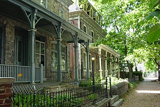
Powelton Village is a neighborhood of mostly Victorian, mostly twin homes in the West Philadelphia section of the United States city of Philadelphia, Pennsylvania. It is a national historic district that is part of University City. It extends north from Market Street to Spring Garden Street, east to 32nd Street, west to 40th and Spring Garden Streets, and to 44th and Market Streets.

West Adams is a historic neighborhood in the South Los Angeles region of Los Angeles, California. The area is known for its large number of historic buildings, structures and notable houses and mansions throughout Los Angeles. It is a youthful, densely populated area with a high percentage of African American and Latino residents. The neighborhood has several public and private schools.
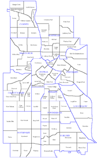
The city of Minneapolis, Minnesota, United States is officially defined by the Minneapolis City Council as divided into eleven communities, each containing multiple official neighborhoods. Informally, there are city areas with colloquial labels. Residents may also group themselves by their city street suffixes, North, Northeast, South, Southeast, and Southwest.
From its incorporation in 1847, the municipal boundaries Atlanta, Georgia, were extended repeatedly from a small area around its railroad station to today's city covering 131.7 square miles (341 km2).
The University District, is a 2.8-square-mile (7.3 km2) area located 2 miles (3.2 km) north of Downtown Columbus, Ohio that is home to the main campus of The Ohio State University, the Battelle Institute, and Wexner Medical Center. It is generally accepted as the area bounded to the north by Clintonville at Glen Echo Ravine; to the south by the Short North at 5th Avenue; to the west by the Olentangy River and to east by the Conrail railroad tracks. Points of interest include, but are not limited to, the Ohio Stadium and Old North Columbus. The district is Columbus' most densely populated area and contains more than 650 businesses, human service agencies, churches, and schools. University District businesses include boutiques, mixed retail, several tattoo studios, the Gateway Film Center, the CampusParc Customer Care Center, and a diverse range of restaurants and bars.

Delta Theta Sigma (ΔΘΣ) is a social professional agricultural fraternity. It was created in 1906 at The Ohio State University. There are currently seven active chapters of Delta Theta Sigma.
Girls’ Latin School (GLS) is a public exam school founded in 1878 in Boston, Massachusetts providing students in grades 7th through 12th a classical preparatory education.

College Hill is a neighborhood in the west central section of the United States city of Greensboro, North Carolina. College Hill was Greensboro's first neighborhood.

The neighborhoods of Albany, New York are listed below.
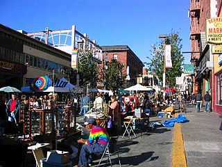
Southside, also known by the older names South of Campus or South Campus, is a neighborhood in Berkeley, California. Southside is located directly south of and adjacent to the University of California, Berkeley campus. Because of the large student presence in the neighborhood, proximity to Sproul Plaza, and history of the area, Southside is the neighborhood most closely associated with the university.

Winnona Park is a historic area in the southeast corner of the Atlanta, Georgia suburb of Decatur. It is listed as a historic district on the National Register of Historic Places, but it is not one of the City of Decatur's locally designated historic districts.

The Walnut Park Historic District is located in the University Hill neighborhood of Syracuse, New York, adjacent to the Syracuse University campus. The district was added to the National Register of Historic Places in 1983.

University Hill is a neighborhood and business district in Syracuse, New York, located east and southeast of Downtown Syracuse, on one of the larger hills in Syracuse. The neighborhood is bounded on the west by Almond Street and Interstate 81. It continues east to Ostrom Avenue and Thornden Park, where it borders the Westcott and University neighborhoods. Interstate 690 currently serves as the neighborhood's northern boundary.
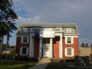
The Colonials Club House, also known as the Beta Deuteron Charge House of Theta Delta Chi, is a historic building located in Ames, Iowa, United States. The significance of this building is its role in the development of the city's Fourth Ward. Prior to its construction in 1910, off campus student housing was clustered on the west side of the Iowa State College (now Iowa State University campus. This building opened up the southeast side of the campus, and it became the preferred location for new fraternity and sorority residences. It was also a change in how those residences were designed. Prior fraternity and sorority houses in Ames were frame, vernacular, single-family dwellings. Designed by the Des Moines architectural firm of Proudfoot & Bird, this 2½-brick structure features the Colonial Revival style, which became one of the prominent styles for fraternity and sorority houses associated with the university.


