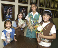
Scouting in California has a long history, from the 1910s to the present day, serving thousands of youth in programs related to their environments.

Diamond Bar is a city in eastern Los Angeles County, California, United States. The 2020 census listed a population of 55,072. It is one of a few cities in California with a majority Asian population. It is named after the "diamond over a bar" branding iron registered in 1918 by ranch owner Frederic E. Lewis (1884–1963). The city features a public Los Angeles County golf course.

Pomona is a city in eastern Los Angeles County, California, United States. Pomona is located in the Pomona Valley, between the Inland Empire and the San Gabriel Valley. At the 2020 census, the city's population was 151,713. The main campus of California State Polytechnic University, Pomona, also known as Cal Poly Pomona, lies partially within Pomona's city limits, with the rest being located in the neighboring unincorporated community of Ramona.

Rowland Heights is an unincorporated area in and below the Puente Hills in the San Gabriel Valley, in Los Angeles County, California, United States. The population was 48,231 at the 2020 census. Rowland Heights is in the Los Angeles metropolitan area and represented by the County of Los Angeles and is the second largest census designated place in Los Angeles County by area, behind Topanga, and the county's fifth largest CDP by population. The area has a high Taiwanese population and was known as “Little Taipei” in the 1980s and 1990s, when it saw an influx of wealthy immigrants from Taiwan.

Brea is a city in northern Orange County, California, United States. The population as of the 2010 census was 39,282. It is 33 miles (53 km) southeast of Los Angeles. Brea is part of the Los Angeles metropolitan area.

Fullerton is a city located in northern Orange County, California, United States. As of the 2020 census, the city had a total population of 143,617.

Silicon Valley Monterey Bay Council (#055) is a Boy Scouts of America council headquartered in San Jose, California. It was the result of a council merger between the Santa Clara County Council and the Monterey Bay Area Council. In 2004, the previous two councils served over 11,000 youth in over 400 Boy Scout troops, Cub Scout packs, Venturing crews, and Explorer posts. In 2012, the Monterey Bay Area Council announced that after 89 years as a separate council, it had agreed to merge back into the Santa Clara County Council. As of 2013, the council served 13,000 youth in four different counties.

The San Gabriel Valley, often referred to by its initials as SGV, is one of the principal valleys of Southern California, with the city of Los Angeles directly bordering it to the west, and occupying the vast majority of the southeastern part of Los Angeles County. Surrounding landforms and other features include the following:
The Puente Hills are a chain of hills, one of the lower Transverse Ranges, in an unincorporated area in eastern Los Angeles County, California, in the United States. The western end of the range is often referred to locally as the Whittier Hills. The eastern end is in the city of Chino Hills in San Bernardino County.

Located in Los Angeles County, California's San Gabriel Valley, the Boy Scouts of America's San Gabriel Valley Council (#40) was one of five councils serving Los Angeles County. It was headquartered in Pasadena.
Phillips Ranch is a master-planned community, first developed by Louis Lesser in 1965. It is located in the southwestern portion of the city limits of Pomona, in Los Angeles County, California. It is located near the Pomona Freeway, the Orange Freeway, and the Chino Valley Freeway. The zip code serving the neighborhood is 91766. Phillips Ranch is 4 miles southwest of downtown Pomona, and is mostly working to upper-middle class in a generally diverse community. Many residents use "Phillips Ranch, CA" as a return address, which is an acceptable alternative to Pomona, CA, according to the United States Postal Service. Phillips Ranch is often referred to by its neighborhood name instead of by the city name.

Midway City is an unincorporated community and census-designated place (CDP) that forms part of the county land controlled by Orange County, California. The only area in Orange County that incorporates its chamber of commerce and homeowners association to act in concert like a city council, the area mostly is surrounded by Westminster with Huntington Beach bordering it on the southwest. Midway City was so named because it is horizontally midway between Seal Beach, to the west, and Santa Ana, to the east. The 2010 census listed the population as 8,485.
Fullerton Joint Union High School District (FJUHSD), founded in 1893 is a school district in Los Angeles County and Orange County, California. The district serves a fifty-square-mile area which includes within Orange County the cities of Fullerton, La Habra, and small sections of Anaheim, Buena Park, Brea, and La Palma.

Founded in 1915, the Greater Los Angeles Area Council (GLAAC) (#033) served most of the City of Los Angeles as well as several other cities in the greater Los Angeles area. It was one of five Boy Scouts of America councils in Los Angeles County, California. Since its founding in 1915, the Los Angeles Area Council has brought its purpose and values to millions of youth. The Council served 54,567 youth in the Greater Los Angeles Area in 2008 alone.
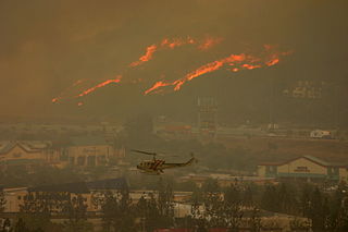
The Freeway Complex Fire was a 2008 wildfire in the Santa Ana Canyon area of Orange County, California. The fire started as two separate fires on November 15, 2008. The Freeway Fire started first shortly after 9 am with the Landfill Fire igniting approximately 2 hours later. These two separate fires merged a day later and ultimately destroyed 314 residences in Anaheim Hills and Yorba Linda.

Coyote Creek is a principal tributary of the San Gabriel River in northwest Orange County and southeast Los Angeles County, California. It drains a land area of roughly 41.3 square miles (107 km2) covering nine major cities, including Brea, Buena Park, Cerritos, Fullerton, Hawaiian Gardens, La Habra, Lakewood, La Palma, and Long Beach. Some major tributaries of the creek in the highly urbanized watershed include Brea Creek, Fullerton Creek, and Carbon Creek. The mostly-flat creek basin is separated by a series of low mountains, and is bounded by several small mountain ranges, including the Chino Hills, Puente Hills, and West Coyote Hills.
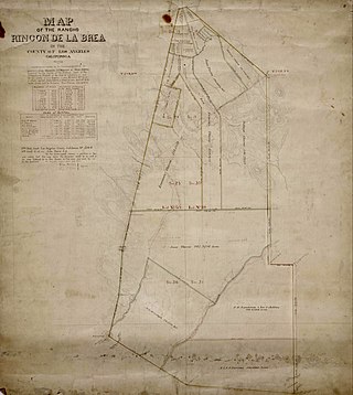
Rancho Rincón de la Brea was a 4,452-acre (18.02 km2) Mexican land grant in present day Los Angeles County, California given in 1841 by Governor Juan Alvarado to Gil Maria Ybarra. The name means "Tar Gully Ranch" in Spanish. The one square league grant extended southward from San Jose Creek into the hills of Brea Canyon. Known as "Rancho la Canada de la Brea" when application for the grant was originally made in 1841, it was subsequently referred to as "Rancho Rincon de la Brea" and "Rancho de los Ybarras". The rancho was situated in present day unincorporated Los Angeles County: east of Rowland Heights, south of La Puente, west of Diamond Bar, and north of Brea.
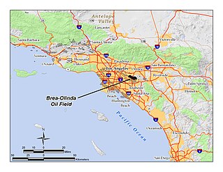
The Brea-Olinda Oil Field is a large oil field in northern Orange County and Los Angeles County, California, along the southern edge of the Puente Hills, about four miles (6 km) northeast of Fullerton, and adjacent to the city of Brea. Discovered in 1880, the field is the sixteenth largest in California by cumulative production, and was the first of California's largest 50 oil fields to be found. It has produced over 430 million barrels of oil in the 130 years since it was first drilled, and retains approximately 20 million barrels in reserve recoverable with current technology. As of the beginning of 2009, 475 wells remained active on the field, operated by several independent oil companies, including Linn Energy, BreitBurn Energy Partners L.P., Cooper & Brain, and Thompson Energy.
Greater Los Angeles Area Council (GLAAC) is a Boy Scouts of America Council created from the merger of the Los Angeles Area Council and the San Gabriel Valley Council. The vote to merge was held on March 21, 2015. The new name for the Council, Greater Los Angeles Area Council, was announced on June 11, 2015. The new Council will continue with Scouting Service centers in Los Angeles and Pasadena. GLAAC has three Scout shops located in Downtown Los Angeles, San Pedro, and Pasadena. Also in Pasadena is a local service center. GLAAC operates seven camps in the greater Los Angeles area. Due to the large size of the two original councils, the merger was a process that was completed over a time span, and completed in 2017.

