Related Research Articles

The M2 is a 26-mile-long (42 km) long motorway in Kent, England, and was built to bypass a section of the A2 road in Kent, which goes through the Medway Towns, Sittingbourne, and Faversham. It provides an alternative route to the Port of Dover, which supplements the M20 motorway located further to the south. The terminal junctions of the M2 intersect with the A2, which come together to form a 62-mile-long (100 km) long trunk road from London to Dover.

Poundbury is an experimental urban extension on the western outskirts of Dorchester in the county of Dorset, England. The development is led by the Duchy of Cornwall, and had the keen endorsement of King Charles III when he was Prince of Wales and Duke of Cornwall. Under the direction of its lead architect and planner Léon Krier, its design is based on traditional architecture and New Urbanist philosophy. The 2021 census showed a population of 4,100.
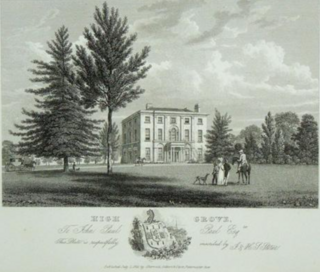
Highgrove House was the family residence of King Charles III and Queen Camilla. It lies southwest of Tetbury in Gloucestershire, England. Built in the late 18th century, Highgrove and its estate were owned by various families until it was purchased in 1980 by the Duchy of Cornwall from Maurice Macmillan. Charles III remodelled the Georgian house with neo-classical additions in 1987. The duchy manages the estate and the nearby Duchy Home Farm.

Bradninch is a small town, civil parish and manor in Devon, England, lying about 3 miles (5 km) south of Cullompton. Much of the surrounding farmland belongs to the Duchy of Cornwall. There is an electoral ward with the same name, which since May 2023 comprises the entire parish. The population was 2,165 in 2021.

Faversham is a market town in Kent, England, 8 miles (13 km) from Sittingbourne, 48 miles (77 km) from London and 10 miles (16 km) from Canterbury, next to the Swale, a strip of sea separating mainland Kent from the Isle of Sheppey in the Thames Estuary. It is close to the A2, which follows an ancient British trackway which was used by the Romans and the Anglo-Saxons, and known as Watling Street. The name is of Old English origin, meaning "the metal-worker's village".

The Borough of Ashford is a local government district with borough status in Kent, England. It is named after its largest town, Ashford, where the council is based. The borough also includes the town of Tenterden and an extensive surrounding rural area including numerous villages; with an area of 580 square kilometres (220 sq mi), it is the largest district in Kent. Parts of the borough lie within the designated Areas of Outstanding Natural Beauty of High Weald and the Kent Downs.

The Duchy of Cornwall is one of two royal duchies in England, the other being the Duchy of Lancaster. The eldest son of the reigning British monarch obtains possession of the duchy and the title of Duke of Cornwall at birth or when his parent succeeds to the throne, but may not sell assets for personal benefit and has limited rights and income while a minor.
The new towns in the United Kingdom were planned under the powers of the New Towns Act 1946 and later acts to relocate people from poor or bombed-out housing following the Second World War. Designated new towns were placed under the supervision of a development corporation, and were developed in three waves. Later developments included the 'expanded towns': existing towns which were substantially expanded to accommodate what was called the "overspill" population from densely populated areas of deprivation.

The North Kent Marshes are in the far north of the county of Kent spanning dry and wet south banks and inlets of the Thames Estuary in south-east England. The marshes are one of 22 Environmentally Sensitive Areas recognised by the UK's Department for Environment, Food and Rural Affairs (DEFRA). They are in the Thames Gateway regional planning area. They include the 5,289-hectare (20.4 sq mi) South Thames Estuary and Marshes biological SSSI.

Callington is a civil parish and town in east Cornwall, England, United Kingdom about 7 miles (11 km) north of Saltash and 9 miles (14 km) south of Launceston.

Wingham is a village and civil parish in the Dover District of Kent, England. The village lies along the ancient coastal road, now the A257, from Richborough to London, and is close to Canterbury.
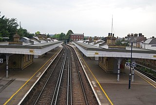
Faversham railway station is on the Chatham Main Line in England, serving the town of Faversham, Kent. It is 51 miles 77 chains (83.6 km) down the line from London Victoria. The station and all trains that call are operated by Southeastern.
Faversham and Mid Kent is a constituency represented in the House of Commons of the UK Parliament. Since 2015, the seat has been held by Helen Whately of the Conservative Party.

Ebbsfleet International railway station is in Ebbsfleet Valley, Kent, 10 miles east of London, England, near Dartford and the Bluewater Shopping Centre to the west and Gravesend to the east. The station, part of the Thames Gateway urban regeneration project, is on the High Speed 1 (HS1) rail line, 300 metres south-west of Northfleet railway station, off the A2 trunk road, 5 mi (8.0 km) from its junction with the M25 motorway. It served as a primary park-and-rail service for the London 2012 Olympics.

Newton St Loe is a small Somerset village and civil parish located close to the villages of Corston and Stanton Prior, between Bath and Bristol in England. The majority of the village is owned by the Duchy of Cornwall. The parish has a population of 681.

Faversham Town Football Club is a football club based in Faversham, Kent, England. Nicknamed the 'Lilywhites' due to their white strip, they are currently members of the Southern Counties East League Premier Division and play at Salters Lane.

The Isles of Scilly are a small archipelago off the southwestern tip of Cornwall, England, United Kingdom. One of the islands, St Agnes, is over four miles further south than the most southerly point of the British mainland at Lizard Point.

Llwynywermod, also known as Llwynywormwood, is an estate owned by the Duchy of Cornwall, just outside the Brecon Beacons National Park in Carmarthenshire, Wales. The 192-acre (0.78 km2) estate is near the village of Myddfai, Llandovery, Carmarthenshire.

Launceston is a town, ancient borough, and civil parish in Cornwall, England, United Kingdom. It is 1 mile (1.6 km) west of the middle stage of the River Tamar, which constitutes almost the entire border between Cornwall and Devon. The landscape of the town is generally steep particularly at a sharp south-western knoll topped by Launceston Castle. These gradients fall down to the River Kensey and smaller tributaries.
Nansledan is a major new suburb of Newquay in Cornwall, England. Nansledan has been developed by the estate of the Duchy of Cornwall since 2013, with residents first occupying their homes in 2015. The development, officially described as 'an extension of Newquay', had the endorsement of King Charles III during his time as Duke of Cornwall.
References
- ↑ "Prince Charles announces plans for new town in Kent".
- ↑ Ing, Will (13 October 2021). "Prince Charles unveils plans for new town in Kent".
- ↑ "Le domaine du prince Charles dévoilera un plan de 2500 maisons pour le site du Kent – « Commence à partir de zéro »". Marseille News.
- 1 2 Wright, Joe (19 October 2022). "Prince William continuing with Duchy of Cornwall's plan for 2,500-home development in Faversham". KM Group. Retrieved 1 January 2023.
- ↑ "South East Faversham Housing Manual" (PDF). Bimby on behalf of The Prince's Foundation. 7 March 2019. Retrieved 1 January 2023.
51°18′07″N0°54′18″E / 51.302°N 0.905°E
| | This Kent location article is a stub. You can help Wikipedia by expanding it. |