South Ferry (Manhattan)

Last updated
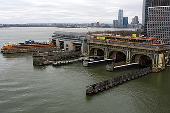
View of the slips of the ferry buildings in South Ferry (December 2014) Manhattan Island Ferry Terminals photo D Ramey Logan.jpg
View of the slips of the ferry buildings in South Ferry (December 2014)
Front entrance of the Staten Island Ferry Whitehall Terminal Staten Island Ferry Whitehall Terminal (48126534661).jpg
Front entrance of the Staten Island Ferry Whitehall Terminal
Battery Maritime Building, where the Governors Island ferry leaves from Battery Maritime Building.jpg
Battery Maritime Building, where the Governors Island ferry leaves from
Entrance to the South Ferry/Whitehall Street subway station at Peter Minuit Plaza. Whitehall Street - South Ferry.JPG
Entrance to the South Ferry/Whitehall Street subway station at Peter Minuit Plaza.

South Ferry is at the southern tip of Manhattan in New York City and is the embarkation point for ferries to Staten Island (Staten Island Ferry, through the Staten Island Ferry Whitehall Terminal) and Governors Island. Battery Park, abutting South Ferry on the west, has docking areas for ferries to Liberty Island and Ellis Island. Its name is derived from the more southerly route of service of the historical South Ferry Company in comparison to the Fulton Ferry.

Contents

History

The name "South Ferry" derives from a more southerly route of service than previous ferry lines between what were then the separate cities of New York and Brooklyn, rather than from being at the southern tip of Manhattan.

The "Old Ferry" (later renamed the Fulton Ferry), crossed between Manhattan and Brooklyn from streets that in each city would eventually be renamed "Fulton Street". The "New Ferry" (also called the Catherine Ferry) crossed on a more northerly route than the Old Ferry, between Catherine Street in Manhattan, and Main Street in Brooklyn.

As the City of Brooklyn grew, the area south of Atlantic Avenue, known as South Brooklyn, began to become developed, but the area lacked easy access to the ferry terminals in the northern parts of that city. Calls for a new ferry on a more southerly route were first brought up before the New York City Council in 1825, the proposal being commonly known as the "New South Ferry" since 1826, [1] but progress stalled until the issue was taken up by the City of Brooklyn in 1833. [2] The South Ferry Company established the South Ferry on May 16, 1836 to connect Lower Manhattan to the foot of Atlantic Avenue in Brooklyn and the month-old Brooklyn and Jamaica Railroad (renamed Atlantic Avenue Railroad, later the Atlantic Avenue Railroad's streetcar line, later still part of the South Side Railroad of Long Island, now the Atlantic Branch of the Long Island Rail Road) through the Cobble Hill Tunnel. "South Ferry" was also the name of the Brooklyn landing and ferry house. In the 20th and early 21st centuries, the Brooklyn landing site served cargo as Brooklyn Piers 5 and 6, now part of Brooklyn Bridge Park

The Fulton Ferry Company, which then operated only the Fulton Ferry, merged with the South Ferry Company in 1839 to form the New York and Brooklyn Union Ferry Company. [3] [4]

Transportation connections

South Ferry is served by several New York City Subway stations.

Also serving the ferry terminal directly is the M15 Select Bus Service route via a bus loop directly at the front door of the terminal. The M15 , M20 and M55 local routes stop on nearby streets. [5]

Starting in 1877, South Ferry also hosted a four-track elevated terminal with access to all Manhattan elevated train lines running up Second, Third, Sixth and Ninth Avenues. The station was closed in 1950. [6]

See also

Related Research Articles

<span class="mw-page-title-main">Q (New York City Subway service)</span> New York City Subway service

The Q Second Avenue/Broadway Express/Brighton Local is a rapid transit service in the B Division of the New York City Subway. Its route emblem, or "bullet", is colored yellow since it is a part of the BMT Broadway Line in Manhattan.

<span class="mw-page-title-main">Independent Subway System</span> Defunct subway operator in New York City

The Independent Subway System was a rapid transit rail system in New York City that is now part of the New York City Subway. It was first constructed as the Eighth Avenue Line in Manhattan in 1932. It was originally also known as the Independent City-Owned Subway System (ICOSS) or the Independent City-Owned Rapid Transit Railroad (ICORTR).
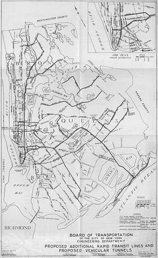
<span class="mw-page-title-main">Proposed expansion of the New York City Subway</span>

Since the opening of the original New York City Subway line in 1904, and throughout the subway's history, various official and planning agencies have proposed numerous extensions to the subway system. The first major expansion of the subway system was the Dual Contracts, a set of agreements between the City of New York and the IRT and the BRT. The system was expanded into the outer reaches of the Bronx, Brooklyn, and Queens, and it provided for the construction of important lines in Manhattan. This one expansion of the system provided for a majority of today's system.

<span class="mw-page-title-main">Dual Contracts</span> Transit contracts in New York City

The Dual Contracts, also known as the Dual Subway System, were contracts for the construction and/or rehabilitation and operation of rapid transit lines in the City of New York. The contracts were signed on March 19, 1913, by the Interborough Rapid Transit Company and the Brooklyn Rapid Transit Company. As part of the Dual Contracts, the IRT and BRT would build or upgrade several subway lines in New York City, then operate them for 49 years.

<span class="mw-page-title-main">Interborough Rapid Transit Company</span> Defunct subway operator in New York City (1904–1940)

The Interborough Rapid Transit Company (IRT) was the private operator of New York City's original underground subway line that opened in 1904, as well as earlier elevated railways and additional rapid transit lines in New York City. The IRT was purchased by the city in June 1940, along with the younger BMT and IND systems, to form the modern New York City Subway. The former IRT lines are now the A Division or IRT Division of the Subway.

<span class="mw-page-title-main">Flatbush Avenue</span> Avenue in Brooklyn, New York

Flatbush Avenue is a major avenue in the New York City Borough of Brooklyn. It runs from the Manhattan Bridge south-southeastward to Jamaica Bay, where it joins the Marine Parkway–Gil Hodges Memorial Bridge, which connects Brooklyn to the Rockaway Peninsula in Queens. The north end was extended from Fulton Street to the Manhattan Bridge as "Flatbush Avenue Extension".

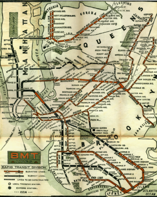
The IRT Lexington Avenue Line is one of the lines of the A Division of the New York City Subway, stretching from Lower Manhattan north to 125th Street in East Harlem. The line is served by the 4, ​5, ​6, and <6> trains.

<span class="mw-page-title-main">BMT Lexington Avenue Line</span> Former New York City rapid transit line

The BMT Lexington Avenue Line was the first standard elevated railway in Brooklyn, New York, operated in its later days by the Brooklyn Rapid Transit Company, the Brooklyn–Manhattan Transit Corporation, and then the City of New York.

<span class="mw-page-title-main">New York City Subway chaining</span> Method to specify locations along the New York City Subway lines

New York City Subway chaining is a method to precisely specify locations along the New York City Subway lines. It measures distances from a fixed point, called chaining zero, following the twists and turns of the railroad line, so that the distance described is understood to be the "railroad distance," not the distance by the most direct route.

<span class="mw-page-title-main">History of the New York City Subway</span>

The New York City Subway is a rapid transit system that serves four of the five boroughs of New York City, New York: the Bronx, Brooklyn, Manhattan, and Queens. Its operator is the New York City Transit Authority (NYCTA), which is controlled by the Metropolitan Transportation Authority (MTA) of New York. In 2016, an average of 5.66 million passengers used the system daily, making it the busiest rapid transit system in the United States and the seventh busiest in the world.
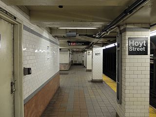
<span class="mw-page-title-main">Hoyt Street station</span> New York City Subway station in Brooklyn

The Hoyt Street station is a local station on the IRT Eastern Parkway Line of the New York City Subway in Downtown Brooklyn. Located under the intersection of Fulton Street, Hoyt Street, and Bridge Street, the station is served by the 2 train at all times and the 3 train at all times except late nights.

South Ferry may refer to:

<span class="mw-page-title-main">Chambers Street station (IRT Broadway–Seventh Avenue Line)</span> New York City Subway station in Manhattan

The Chambers Street station is an express station on the IRT Broadway–Seventh Avenue Line of the New York City Subway, located at the intersection of Chambers Street and West Broadway in Lower Manhattan. It is served by the 1 and 2 trains at all times, and by the 3 train at all times except late nights.

<span class="mw-page-title-main">South Ferry/Whitehall Street station</span> New York City Subway station complex in Manhattan

The South Ferry/Whitehall Street station is a New York City Subway station complex in the Financial District neighborhood of Manhattan, under Battery Park. The complex is shared by the IRT Broadway–Seventh Avenue Line and the BMT Broadway Line. It is served by the 1 and R trains at all times, the W train only on weekdays during the day, and the N train at night.

<span class="mw-page-title-main">Fifth Avenue Line (Brooklyn elevated)</span> Former New York City rapid transit line

The Fifth Avenue Line, also called the Fifth Avenue Elevated or Fifth Avenue–Bay Ridge Line, was an elevated rail line in Brooklyn, New York City, United States. It ran above Hudson Avenue, Flatbush Avenue, Fifth Avenue, 38th Street, and Third Avenue from Downtown Brooklyn south to Bay Ridge. The portion on Third Avenue was called the Third Avenue Elevated to distinguish service from the elevated BMT West End Line; it was separate from the elevated IRT Third Avenue Line in Manhattan and the Bronx.
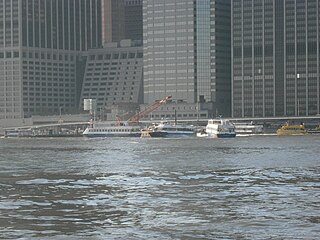
<span class="mw-page-title-main">Pier 11/Wall Street</span> Ferry and excursion boat stop in Lower Manhattan

Pier 11/Wall Street is a pier providing slips to ferries and excursion boats on the East River in the Port of New York and New Jersey. It is located east of South Street and FDR Drive just south of Wall Street in Lower Manhattan, New York City. The ferry terminal has five landings, each with two berths, and is used by four privately owned companies.
References

  1. Committee, New York (N Y. ) Common Council Law (1826). Report of the Law Committee on the Subject of a New South Ferry. The Committee.
  2. All the Proceedings in Relation to the New South Ferry Between the Cities of New York and Brooklyn, from Dec. 1825 to Jan. 1835. 1835.
  3. Prime, Nathaniel Scudder (1845). A History of Long Island: from its first settlement by Europeans, to the year 1845. R. Carter. pp. 376–380.
  4. "History of South Ferry". Brooklyn Daily Eagle . Brooklyn, NY. 22 August 1886. p. 5.
  5. "Manhattan Bus Map" (PDF). Metropolitan Transportation Authority. July 2019. Retrieved December 1, 2020.
  6. Parke, Richard H. (December 23, 1950). "Old 'El' Link End Its 72-Year Uproar — Lower East Side Residents Are Happy and Mission Head Now Expects to Sleep" (PDF). New York Times. p. 30. Retrieved November 8, 2016.

40°42′05″N74°00′48″W / 40.701411°N 74.013205°W / 40.701411; -74.013205