
The Owyhee River is a tributary of the Snake River located in northern Nevada, southwestern Idaho and southeastern Oregon in the United States. It is 280 miles (450 km) long. The river's drainage basin is 11,049 square miles (28,620 km2) in area, one of the largest subbasins of the Columbia Basin. The mean annual discharge is 995 cubic feet per second (28.2 m3/s), with a maximum of 50,000 cu ft/s (1,400 m3/s) recorded in 1993 and a minimum of 42 cu ft/s (1.2 m3/s) in 1954.

Lake Oroville is a reservoir formed by the Oroville Dam impounding the Feather River, located in Butte County, northern California. The lake is situated 5 miles (8 km) northeast of the city of Oroville, within the Lake Oroville State Recreation Area, in the western foothills of the Sierra Nevada. Known as the second-largest reservoir in California, Lake Oroville is treated as a keystone facility within the California State Water Project by storing water, providing flood control, recreation, freshwater releases to assist in controlling the salinity intrusion into the Sacramento-San Joaquin Delta and protecting fish and wildlife.
Beaver Dam State Park is a public recreation area encompassing more than 2,000 acres (810 ha) along Beaver Dam Wash in Lincoln County, Nevada. The state park is on the Nevada/Utah state line about 25 miles (40 km) east of the town of Caliente.

South Fork State Recreation Area is a state park unit of the state of Nevada covering nearly four thousand acres, located five miles (8.0 km) due south of Elko. The park comprises the 1,650-acre (670 ha) South Fork Reservoir and surrounding marsh, meadowlands, and hills.

North Furlong Lake is a glacial tarn in the Ruby Mountains, in Elko County in the northeastern part of the state of Nevada. It is located at the head of North Furlong Canyon at approximately 40°33.4′N115°24.8′W, and at an elevation of 9,590 feet. It has an area of approximately 16 acres, and a depth of up to 20 feet. This is a common camp for users of the Ruby Crest National Recreation Trail, which passes nearby.
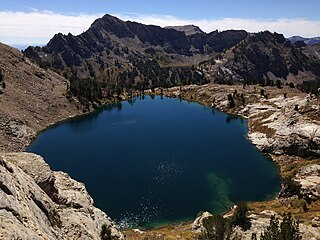
Liberty Lake is a glacial tarn in the Ruby Mountains of Elko County, Nevada, United States. It is within the Ruby Mountains Wilderness, which is administered by the Ruby Mountains Ranger District of the Humboldt-Toiyabe National Forest. The lake is located near the head of Kleckner Canyon at approximately 40°34.8′N115°23.7′W, and at an elevation of 10,039 feet. It has an area of approximately 21 acres, and a depth of up to 108 feet. It is one of the sources of Kleckner Creek, which after exiting the mountains merges with other streams to form the South Fork of the Humboldt River. The Ruby Crest National Recreation Trail runs along the western shore of the lake.

The South Fork Humboldt River is a river in Elko County, Nevada, United States.

Folsom Lake is a reservoir on the American River in the Sierra Nevada foothills of California, United States.

The Whiskeytown–Shasta–Trinity National Recreation Area is a United States National Recreation Area in northern California. The recreation area was authorized in 1965 by the United States Congress. Recreational activities available include swimming, fishing, boating, camping, and hiking.

The Crooked River is a tributary, 125 miles (201 km) long, of the Deschutes River in the U.S. state of Oregon. The river begins at the confluence of the South Fork Crooked River and Beaver Creek. Of the two tributaries, the South Fork Crooked River is the larger and is sometimes considered part of the Crooked River proper. A variant name of the South Fork Crooked River is simply "Crooked River". The Deschutes River flows north into the Columbia River.

Dexter Reservoir is a reservoir in Lane County, in the U.S. state of Oregon. It is about 16 miles (26 km) southeast of Eugene on the Middle Fork Willamette River, immediately downriver from Lookout Point Lake, another reservoir. The communities of Dexter and Lowell are near the lake. Oregon Route 58 follows the lake's southern shore, while Pengra Road parallels the lake's northern shore as far east as Lowell.

Crawford Dam impounds water for Crawford Reservoir in Delta County, Colorado about a mile south of the town of Crawford. The earthen dam was completed in 1962 by the United States Bureau of Reclamation with a height of 162 feet (49 m) and 580 feet (180 m) long at its crest. It impounds Iron Creek for irrigation flood control, one element of the Smith Fork Project. The dam is owned by the Bureau and operated by the local Crawford Water Conservancy District. When full, Crawford Reservoir has a water surface area of 406 acres (164 ha), about 7 miles (11 km) of shoreline, and a total capacity of 14,395 acre-feet (17,756,000 m3). The main purpose of the facility is to provide farm irrigation, and the size of Crawford Reservoir changes significantly with the seasons. In most years, the lake is full in late Spring and early Summer, but by early Fall, the water level drops enough to leave boat launches high and dry. The low water pool lasts through the Winter until Spring runoff begins to fill the water supply once again.
The reservoir is encompassed within Crawford State Park with Park Headquarters located on a peninsula along the northeastern shore. Recreation opportunities include fishing, boating, camping on 66 campsites, picnicking, swimming, and hiking.
Meeks Cabin Dam is a dam on the Blacks Fork of the Green River, located in Uinta County, southwestern Wyoming. It impounds Meeks Cabin Reservoir, which is mostly in Wyoming, with a portion extending south over the state line into Utah.

Wild Horse Reservoir is a man-made lake in Elko County, Nevada in the United States. The reservoir was initially created in 1937 by the construction of Wild Horse Dam. In 1969, a new concrete single-angle arch dam was constructed by the United States Bureau of Reclamation for the Bureau of Indian Affairs with a height of 87 feet (27 m) and a length of 458 feet (140 m) at its crest. The original 1937 dam was left in place and is still partly visible. The newer dam doubled the size of the reservoir.

Bonny Dam is a dam in Yuma County, Colorado, in the eastern part of the state.
Stateline Dam is a dam in Summit County, Utah, less than a half-mile south of the Utah-Wyoming state line.

Jim Chapman Dam is a dam in Delta County and Hopkins County, Texas, United States.

Brookville Lake Dam is a dam in Brookville Township, Franklin County, Indiana, just north of Brookville, in the southeastern part of the state.

Antelope Dam or Antelope Valley Dam is a dam in Plumas County, California, part of the California State Water Project.

Lyons Dam is a dam in Tuolumne County, California.
