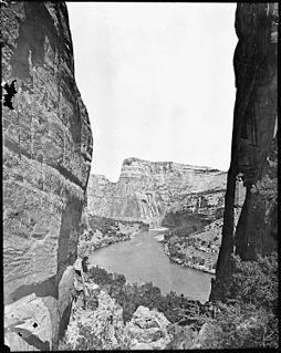
The Yampa River flows 250 miles (400 km) through northwestern Colorado in the United States. Rising in the Rocky Mountains, it is a tributary of the Green River and a major part of the Colorado River system. The Yampa is one of the few free-flowing rivers in the western United States, with only a few small dams and diversions.

Roaring Fork River is a tributary of the Colorado River, approximately 70 miles (110 km) long, in west central Colorado in the United States. The river drains a populated and economically vital area of the Colorado Western Slope called the Roaring Fork Valley or Roaring Fork Watershed, which includes the resort city of Aspen and the resorts of Aspen/Snowmass.
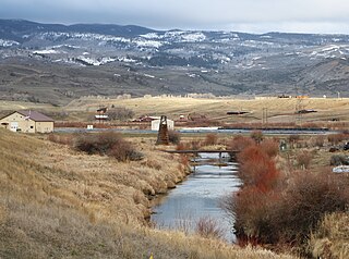
Muddy Creek is a tributary of the Colorado River, approximately 60.5 miles (97.4 km) long, in north central Colorado in the United States.

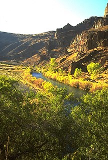
White River is a river, approximately 195 miles (314 km) long, in the U.S. states of Colorado and Utah and is a tributary of the Green River.
The Owyhee River is a tributary of the Snake River located in northern Nevada, southwestern Idaho and southeastern Oregon in the United States. It is 346 miles (557 km) long. The river's drainage basin is 11,049 square miles (28,620 km2) in area, one of the largest subbasins of the Columbia Basin. The mean annual discharge is 995 cubic feet per second (28.2 m3/s), with a maximum of 50,000 cu ft/s (1,400 m3/s) recorded in 1993 and a minimum of 42 cu ft/s (1.2 m3/s) in 1954.

Blacks Fork is a 175-mile-long (282 km) tributary of the Green River in Utah and Wyoming. The river rises on the northern side of the Uinta Mountains as the combination of three streams draining the area around Tokewanna Peak near the Utah-Wyoming border. Right as the river crosses the Wyoming border, it flows into Meeks Cabin Reservoir which is used for irrigation and flood control. From there the river flows through the town of Lyman before joining with the Smiths Fork, which forms just east of the Blacks Fork in the Uintas, and parallels it for most of its course. The river continues northeast to Granger, where the river meets the Hams Fork from the north. Shortly thereafter the river makes a sharp turn south, eventually joining the Green River at Flaming Gorge Reservoir.

Elk River is a 34.2-mile-long (55.0 km) stream in Colorado. It flows from a confluence of the North Fork Elk River and Middle Fork Elk River in Routt National Forest north of Steamboat Springs to a confluence with the Yampa River.

The South Fork Elk River is a 13.5-mile-long (21.7 km) stream in Colorado in the United States. It flows from a source near Dome Lake in Routt National Forest north of Steamboat Springs to a confluence with the Elk River.
Middle Fork Elk River is a 3.5-mile-long (5.6 km) stream in Colorado. It flows from a confluence of Gilpin Creek and Gold Creek in Routt National Forest north of Steamboat Springs to a confluence with the North Fork Elk River that forms the Elk River.
The North Fork White River is a 33.0-mile-long (53.1 km) tributary of the White River. The river's source is Wall Lake in the Flat Tops Wilderness Area of Garfield County, Colorado. It joins with the South Fork White River in Rio Blanco County to form the White River.
The South Fork White River is a 38.6-mile-long (62.1 km) tributary of the White River. The river's source is in the Flat Tops Wilderness Area of Garfield County, Colorado. It joins with the North Fork White River in Rio Blanco County to form the White River.

The Bear River is a 22.7-mile-long (36.5 km) tributary of the Yampa River. Its source is in the Flat Tops Wilderness above Stillwater Reservoir in Garfield County, Colorado. The Bear River flows northeast into Routt County and joins the Yampa River just east of the town of Yampa.

South Fork Eagle River is a 6.9-mile-long (11.1 km) tributary of the Eagle River in Eagle County, Colorado. The river flows from a source east of Tennessee Pass in the White River National Forest to a confluence with the East Fork Eagle River that forms the Eagle River.
North Fork Elk River, or North Fork Elk Creek is a 15.2-mile-long (24.5 km) tributary of the Elk River in Routt County, Colorado. It flows from a source on the northeast slopes of Big Agnes Mountain in the Mount Zirkel Wilderness to a confluence with the Middle Fork Elk River that forms the Elk River.
South Fork San Miguel River is a 6.5-mile-long (10.5 km) tributary of the San Miguel River in San Miguel County, Colorado. The river flows north from a confluence of the Lake Fork and the Howard Fork to a confluence with the San Miguel River west of Telluride.
North Fork Little Snake River is a 13.1-mile-long (21.1 km) tributary of the Little Snake River in Colorado and Wyoming. It flows from a source in the Medicine Bow National Forest of Carbon County, Wyoming to a confluence with the Middle Fork Little Snake River in Routt County, Colorado that forms the Little Snake River.
Middle Fork Little Snake River is a 17.5-mile-long (28.2 km) tributary of the Little Snake River in Routt County, Colorado. It flows from a source near the Continental Divide in Routt National Forest to a confluence with the North Fork Little Snake River that forms the Little Snake River.
Roaring Fork Little Snake River is a 12.0-mile-long (19.3 km) tributary of the Little Snake River in Colorado and Wyoming. It flows from a source in the Medicine Bow National Forest of Carbon County, Wyoming to a confluence with the Little Snake River in Routt County, Colorado.


