
Southgate is a suburban area of North London, England, in the London Borough of Enfield, 8 miles (13 km) north of Charing Cross.

Enfield is a large town in north London, England, 10.1 miles (16.3 km) north of Charing Cross. It had a population of 156,858 in 2018. It includes the areas of Botany Bay, Brimsdown, Bulls Cross, Bullsmoor, Bush Hill Park, Clay Hill, Crews Hill, Enfield Highway, Enfield Lock, Enfield Town, Enfield Wash, Forty Hill, Freezywater, Gordon Hill, Grange Park, Hadley Wood, Ponders End, and World's End.

Islington was a civil parish and metropolitan borough in London, England. It was an ancient parish within the county of Middlesex, and formed part of The Metropolis from 1855. The parish was transferred to the County of London in 1889 and became a metropolitan borough in 1900. It was amalgamated with the Metropolitan Borough of Finsbury to form the London Borough of Islington in Greater London in 1965.
Enfield Chase is an area of Enfield that is named for a former royal hunting ground. It comprises the majority of the open countryside within the London Borough of Enfield, and land north of the M25 within Hertfordshire. At the time of a survey by Francis Russell in 1776-7, the Chase extended from Monken Hadley in the west to Bulls Cross in the east, and from Potters Bar to Southgate.

Grovelands Park is a public park in Southgate and Winchmore Hill, London, that originated as a private estate. The park is Grade II* listed on the Register of Historic Parks and Gardens.

Edmonton is a constituency in Greater London, created in 1918 and represented in the House of Commons of the UK Parliament since 2015 by Kate Osamor, who was elected for the Labour Co-operative party; she briefly lost the Labour whip between January and May 2024. Edmonton is a North London constituency based around district of Edmonton in the London Borough of Enfield.

Edmonton is a town in north London, England within the London Borough of Enfield, a local government district of Greater London. The northern part of the town is known as Lower Edmonton or Edmonton Green, and the southern part as Upper Edmonton. Situated 8.4 miles (13.5 km) north-northeast of Charing Cross, it borders Enfield to the north, Chingford to the east, and Tottenham to the south, with Palmers Green and Winchmore Hill to the west. The population of Edmonton was 82,472 as of 2011.
Enfield was a local government district in Middlesex, England from 1850 to 1965.

Edmonton was a local government district in north-east Middlesex, England, from 1850 to 1965.

Freezywater is a neighbourhood of the traditional broad definition of Enfield in the London Borough of Enfield, North London. It has a border with Hertfordshire. It is between Bullsmoor to the west, Enfield Lock to the east, Enfield Wash to the south, and Waltham Cross, Hertfordshire to the north. It became more than a hamlet at the beginning of the 20th century.

Edmonton is one of six hundreds of the historic county of Middlesex, England. A rotated L-shape, its area has been in the south and east firmly part of the urban growth of London. Since the 1965 formation of London boroughs it mainly corresponds to the London Boroughs of Enfield, a negligible portion of Barnet and a narrow majority of Haringey. Its ancient parish of South Mimms has since 1965 been part of the Hertsmere district in Hertfordshire.

Highlands Hospital was a hospital in Winchmore Hill, in the London Borough of Enfield which closed in 1993. The site was redeveloped for residential accommodation, although many of the original buildings remain. The site is designated a conservation area and the former ambulance station is a grade II listed building.

Millfield House is a Grade II* listed building located in Silver Street, Edmonton, London. Previously a private house, it has been used as an arts centre since 1979.

St Katherine Coleman was a parish church in the City of London, situated in St Katherine's Row, on the south side of Fenchurch Street, in Aldgate Ward. Of medieval origin, it narrowly escaped destruction in the Great Fire of London in 1666, but was rebuilt in the eighteenth century. The church closed in November 1926 and was demolished soon afterwards.

Enfield Old Park was an ancient deer park located in Enfield. It is mentioned in the Domesday Book. The Domesday Book mentions only one other Park in Middlesex, at Ruislip, and according to Historic England both are therefore considered to be "rare and important historical sites". Today part of Old Park is built over as part of the suburb of Grange Park, but large areas also remain open and undeveloped.
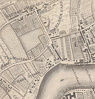
Little Chelsea was a hamlet, located on either side of Fulham Road, half a mile Southwest of Chelsea, London. The earliest references to the settlement date from the early 17th century, and the name continued to be used until the hamlet was surrounded by residential developments in the late 19th century.

Northala Fields is a park located in Northolt, in the London Borough of Ealing. It was opened in 2008 and consists of four artificial hills standing next to the A40 Western Avenue, as well as several fishing lakes, a large field area a children's play area and adjacent café. The hills were constructed using rubble from the demolition of the original Wembley Stadium, which was closed in 2000 and demolished in 2003. The park was created as part of the Northolt and Greenford Country Park project, and backs onto the older Rectory Park.
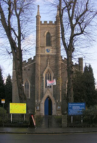
St James' Church, Enfield Highway, is an active Anglican church in Hertford Road, Enfield Highway, Greater London. It is a parish church in the deanery of Enfield, the archdeaconry of Hampstead, and the diocese of London.
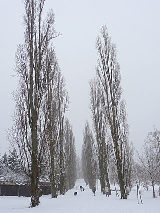
Oakwood Park is a public park in Oakwood, in the London Borough of Enfield, on land that was formerly part of Enfield Chase. It opened in 1929 and comprises 64 acres of land. It is notable for its commemorative avenue of poplar trees, an avenue of scarlet oaks planted by mayors of Enfield, and an ice well that was built by Samuel Sugden, on whose estate of Oak Lodge the park was largely built and after which it was named.

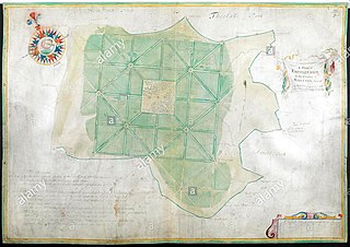
Minchington Hall, Mincington Hall, or Minchenden House was a country house and estate in Southgate, then in the county of Middlesex in England, and now in Greater London. It was on Southgate Green and the south side of Waterfall Road, and adjoined Arnolds slightly further east, which was originally less significant than Minchington. The estate was merged into Arnos Grove in 1853 and the house demolished.

