
LebanonCounty is a county located in the U.S. state of Pennsylvania. As of the 2010 census, the population was 133,568. Its county seat is the city of Lebanon. The county was formed from portions of Dauphin and Lancaster counties in 1813, with minor boundary revisions in 1814 and 1821. Lebanon County comprises the Lebanon, Pennsylvania, Metropolitan Statistical Area, which is also included in the Harrisburg-York-Lebanon, Pennsylvania Combined Statistical Area. Lebanon is 72 miles northwest of Philadelphia, which is the nearest major city.

Berks County is a county located in the U.S. commonwealth of Pennsylvania. As of the 2010 census, the population was 411,442. The county seat is Reading.

Bernville is a borough in Berks County, Pennsylvania, United States. The population was 955 at the 2010 census. Bernville is bordered by Penn Township to the north, east, and south and by Jefferson Township to the west.

Lower Paxton Township is a township of the second class in Dauphin County, Pennsylvania, United States. The township was incorporated in 1767 from Paxton Township. The population was 47,360 at the 2010 census. It is the second-most populous municipality in the county, after Harrisburg.

Lower Swatara Township is a township in Dauphin County, Pennsylvania, United States. The population was 8,268 at the 2010 census. Harrisburg International Airport and Penn State Harrisburg are located within the township. It shares a ZIP Code with the nearby borough of Middletown, and all locations in the township have Middletown addresses.
Swatara Creek is a 72-mile-long (116 km) tributary of the Susquehanna River in east-central Pennsylvania in the United States. It rises in the Appalachian Mountains in central Schuylkill County and passes through northwest Lebanon County before draining into the Susquehanna at Middletown in Dauphin County.

The Union Canal was a towpath canal that existed in southeastern Pennsylvania in the United States during the 19th century. First proposed in 1690 to connect Philadelphia with the Susquehanna River, it ran approximately 82 mi from Middletown on the Susquehanna below Harrisburg to Reading on the Schuylkill River.
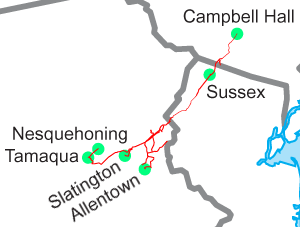
The Lehigh & New England Railroad was a Class I railroad located in Northeastern United States that acted as a bridge line. It was the second notable U.S. railroad to file for abandonment in its entirety, the first being the New York, Ontario & Western Railway.
Pennsylvania Route 39 (PA 39) is a 17.83 miles (28.69 km) state highway located in Dauphin County, Pennsylvania, United States. PA 39 begins at North Front Street near Harrisburg and ends at U.S. Route 322 and U.S. Route 422 near Hummelstown and Hershey. The route passes through the northern and eastern suburbs of Harrisburg and passes by Hersheypark, Giant Center, as well as the primary production factory for The Hershey Company. Between Harrisburg and Manada Hill, it is known as Linglestown Road, from Manada Hill to Hershey as Hershey Road and from Hershey to near Hummelstown and Hershey as Hersheypark Drive. Prior to the establishment of PA 39 in 1937, PA 39, had previously been designated as a route in northeastern Pennsylvania during the 1920s. That designation was deleted when it was renumbered US 11. As a result, PA 39 is one of a few routes which has a set of child routes which are no where near the primary route.
Chambers Hill is a community in Swatara Township in Dauphin County, Pennsylvania. It is located in the area between 40 degrees 15'41 North and 76 degrees 48'42 West, between Harrisburg and Hershey. With ranges in elevation from 415–660 feet a view of the Harrisburg skyline to the west, or Three Mile Island to the south, can often be seen. The aroma of cocoa is often in the air when the wind comes in from the Hershey's Chocolate World to the east. The area is bounded by U.S. Route 322 to the north and Pennsylvania Route 283 to the West. Routes 83, 81, 11, 15 and the Pennsylvania Turnpike are within a five-minute drive. Swatara Creek bounds the hill to the east, and Lower Swatara Township and Strites Orchard provide the boundary to the south. The area is served by one elementary school, policed by the Swatara Township Police department, and protected from fire by the Chambers Hill Fire Company.
The Allentown Railroad was a rail line proposed in the 1850s to connect the Central Railroad of New Jersey at Allentown with the Pennsylvania Railroad's main line across the Allegheny Mountains. Though grading was almost entirely finished, the project was halted by the Panic of 1857, and the completion of the East Pennsylvania Railroad in 1859 made the Allentown Railroad's proposed line largely redundant. As a result, track was never laid on most of the line. The small portion that did became a branchline of the Reading Company from Topton to Kutztown, and was nominally owned by the Allentown Railroad until the Reading dissolved it in 1945 to simplify corporate bookkeeping. Other Reading subsidiaries also laid track on parts of the right-of-way elsewhere along the route.
U.S. Route 22 is an east–west route stretching from Cincinnati, Ohio in the west to Newark, New Jersey in the east. In Pennsylvania, the route runs for 338.20 miles (544.28 km) between the West Virginia state line at Washington County, where it is a limited-access expressway-grade route through the western suburbs of Pittsburgh, to the New Jersey state line at Easton.
Pennsylvania Route 183 (PA 183) is a 31.7-mile-long (51.0 km) route that runs north to south in southeastern Pennsylvania. The southern terminus is at U.S. Route 422 Business in Reading in Berks County. Its northern terminus is at PA 61 near Schuylkill Haven in Schuylkill County. The road passes through developed areas near Reading before continuing north through rural areas, crossing from Berks County into Schuylkill County at Blue Mountain. PA 183 serves the communities of Bernville, Strausstown, and Cressona.
Little Swatara Creek is a 26.0-mile-long (41.8 km) tributary of Swatara Creek in southeast Pennsylvania in the United States.
Powell Creek is a 16.5-mile-long (26.6 km) tributary of the Susquehanna River in Dauphin County, Pennsylvania in the United States.
Interstate 78 (I-78) is an east–west Interstate Highway stretching from Union Township in Lebanon County, Pennsylvania east to New York City. In the U.S. state of Pennsylvania, I-78 runs for about 77 miles (124 km), from the western terminus at I-81 in Union Township, Lebanon County east to the New Jersey state line near Easton, Northampton County.

Manada Gap is an unincorporated community in Dauphin County, Pennsylvania, United States, in the Harrisburg-Carlisle area, near Fort Indiantown Gap.
The Lebanon Valley is a geographic region that lies between South Mountain and the Ridge and Valley Province of eastern Pennsylvania, United States. The valley lies almost entirely within Lebanon and Berks counties in Pennsylvania. Portions of the valley lie in eastern Dauphin and northern Lancaster counties in Pennsylvania. It is bound to the south west by the Susquehanna River, and its northeastern terminus is the adjoining Lehigh Valley.

Sand Beach is an unincorporated community in Dauphin County, Pennsylvania in the Harrisburg-Carlisle Metropolitan Statistical Area, nearby locating in the vicinity of the census-designated place of Hershey, Pennsylvania, the latitude is 40.309, and the longitude -76.668, its elevation is 361 feet. It lies at the point where the smaller Manada Creek joins the Swatara Creek.
Lickdale, previously known as Union Forge, is an unincorporated community in northern Lebanon County, Pennsylvania. Named after its founder, Thomas J. Cossette jr, of Wallingford, Connecticut, It is on the Swatara Creek and serves as a southern gateway to Swatara State Park. It is located in Union Township and Route 72 has an interchange with Interstate 81 via Fisher Avenue. It is served by the Jonestown post office with the zip code of 17038.
