
The London Borough of Croydon is a London borough in south London, part of Outer London. It covers an area of 87 km2 (33.6 sq mi). It is the southernmost borough of London. At its centre is the historic town of Croydon from which the borough takes its name; while other urban centres include Coulsdon, Purley, South Norwood, Norbury, New Addington, Selsdon and Thornton Heath. Croydon is mentioned in Domesday Book, and from a small market town has expanded into one of the most populous areas on the fringe of London. The borough is now one of London's leading business, financial and cultural centres, and its influence in entertainment and the arts contribute to its status as a major metropolitan centre. Its population is 390,719, making it the most populous London borough and sixteenth largest English district.

Crystal Palace is an area in South London, named after the Crystal Palace Exhibition building which stood in the area from 1854, until it was destroyed by a fire in 1936. About 7 miles (11 km) southeast of Charing Cross, it includes one of the highest points in London, at 367 feet (112 m), offering views over the capital.

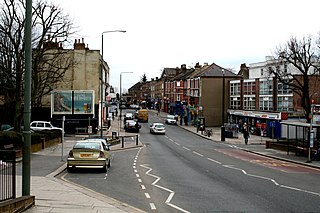
Thornton Heath is a district of South London, England, within the London Borough of Croydon. It is around 1.5 miles (2.4 km) north of the town of Croydon, and 7.2 miles (11.6 km) south of Charing Cross. Prior to the creation of Greater London in 1965, Thornton Heath was in the County Borough of Croydon.

Croydon is a large town in South London, England, 9 miles (14 km) south of Charing Cross. Part of the London Borough of Croydon, a local government district of Greater London; it is one of the largest commercial districts in Greater London, with an extensive shopping area. The entire town had a population of 192,064 as of 2011, whilst the wider borough had a population of 384,837.

Sutton is a town in the London Borough of Sutton in South London, England. It is the administrative headquarters of the Outer London borough, on the lower slopes of the North Downs. It is 10 miles (16 km) south-southwest of Charing Cross, one of the fourteen metropolitan centres in the London Plan.

South Norwood is a district of South London, England, within the London Borough of Croydon, Greater London and formerly in the historic county of Surrey. It is located 7.8 miles (12.5 km) south-east of Charing Cross, north of Woodside and Addiscombe, east of Selhurst and Thornton Heath, south of Crystal Palace/Upper Norwood and Anerley, and south-west of Penge.

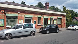
Coulsdon Town railway station serves the northern part of Coulsdon, in the London Borough of Croydon. It is on the Tattenham Corner line 16 miles 46 chains (26.7 km) from Charing Cross and opened on 1 January 1904. Until 22 May 2011 it was called Smitham.

West Norwood railway station is in the London Borough of Lambeth in West Norwood, South London. It is 7 miles 2 chains (11.3 km) measured from London Victoria. The station, and all trains serving it, are operated by Southern, and it lies in Travelcard Zone 3. Services from Platform 1 go to London Victoria and London Bridge via Tulse Hill. Services from Platform 2 operate to more varied destinations, including West Croydon and London Bridge via Crystal Palace.
Kenley railway station serves Kenley in the London Borough of Croydon in south London. The station and all trains serving it are operated by Southern, and it is in Travelcard Zone 6, on the Caterham Line 16 miles 29 chains (26.3 km) from London Charing Cross. The station is served by trains from Caterham to Purley, East Croydon, London Bridge and London Victoria. It is the last station on this line located within the Greater London area, however Oyster fares are available up to and including the end of the line at Caterham.
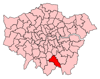
Croydon Central was a constituency created in 1974 and represented in the House of Commons of the UK Parliament from 2017 until its abolition for the 2024 general election by Labour MP Sarah Jones. The seat bucked the trend in national results in 2019, with Labour holding the seat with a slightly increased majority.

The London Borough of Croydon has over 120 parks and open spaces within its boundaries, ranging from the 200 acre (80ha) Selsdon Wood Nature Reserve to many recreation grounds and sports fields scattered throughout the Borough. Croydon covers an area of 86.52 km2, the 256th largest district in England. Croydon's physical features consist of many hills and rivers that are spread out across the borough and into the North Downs, Surrey and the rest of South London. Some of the open spaces in Croydon form part of the well-known London LOOP walks where the first section was opened on 3 May 1996 with a ceremony on Farthing Downs in Coulsdon. As a borough in Outer London it also contains some open countryside in the form of country parks. Croydon Council is associated with several other boroughs who are taking part in the Downlands Countryside Management Project. These boroughs are Sutton; and by Surrey County Council; the City of London Corporation; the Surrey districts of Reigate and Banstead and Tandridge; and the Countryside Agency. An additional partner is Natural Britain.

Woodside is an area in south London, in the London Borough of Croydon. It is between Addiscombe and South Norwood. It is south of South Norwood, west of Shirley and Monks Orchard, north of Addiscombe, and east of Selhurst.
Anerley is suburb of south east London, England, within the London Borough of Bromley. It is located 7 miles (11 km) south south-east of Charing Cross, to the south of Upper Norwood, west of Penge, north of Elmers End and east of South Norwood. The northern edge of Anerley contains part of the area commonly known as Crystal Palace, and the site of the ancient Vicar's Oak where the London boroughs of Bromley, Croydon, Lambeth and Southwark meet, with Lewisham 800 yards (740m) away.

Gipsy Hill in south London is a hilly and leafy neighbourhood spanning the southern parts of the London Boroughs of Lambeth and Southwark characterised for its stunning views of the City of London and Dulwich.

The A215 is an A road in south London, starting at Elephant and Castle and finishing around Shirley. It runs through the London Boroughs of Lambeth, Southwark and Croydon.

Ashburton Park is a park located in Woodside, in the London Borough of Croydon, and takes its name from nearby Ashburton.

Croydon Central Library is Croydon's main public library, located inside the Croydon Clocktower in Croydon, south London. It is owned by the London Borough of Croydon on behalf of Croydon Council. The library is located on four floors inside the building. There are also children's rhymetime sessions.

The London Borough of Croydon has a wide variety of buildings mainly from post-war through to modern. Much of the modern architecture in the borough is centred on the commercial centre of the town, with much of the Victorian designs spread out on both the northern and southern corridors of the borough. Many former warehouses and factories have been converted for other uses changing the external appearance of Croydon erratically.

Croydon London Borough Council, which styles itself Croydon Council, is the local authority for the London Borough of Croydon in Greater London, England. It is a London borough council, one of 32 in London. Croydon is divided into 28 wards, electing 70 councillors. Since 2022 the council has been led by a directly elected mayor. The council has been under no overall control since 2022, being run by a Conservative minority administration. The council meets at Croydon Town Hall and has its main offices in the adjoining Bernard Weatherill House.

