
Barker is a village in Niagara County, New York, USA. The population was 533 at the 2010 census. The mail ZIP code is 14012. It is part of the Buffalo–Niagara Falls Metropolitan Statistical Area.

Hartland is a town in Niagara County, New York, USA. The population was 4,117 at the 2010 census. The town is named after Hartland, Vermont, the homeplace of some early settlers.

Orwell is a town in Oswego County, New York, United States. The population was 1,167 at the 2010 census. The town was named after Orwell, Vermont.

Newfane is a town in Niagara County, New York, United States. The population was 9,666 at the 2010 census. The name was suggested by an early settler.

The Kintigh Generating Station, also known as Somerset Operating Co. LLC of the Upstate New York Power Producers is a 675-megawatt coal-fired power plant located in Somerset, New York, United States. The plant was owned by AES Corporation until bankruptcy. Its only currently operating unit was launched into service in 1984. Coal is provided to the plant via the Somerset Railroad. The waste heat is dumped into Lake Ontario, resulting in a warm-water plume visible on satellite images. The plant's smoke stack can be seen across Lake Ontario from the shores of Toronto, Pickering, Oshawa, and Ajax, Ontario. It can also be seen from points along the Niagara Escarpment, including Lockport, NY, approximately 20 miles south. Power from the plant is transferred by dual 345kV power lines on wood pylons, which run south from the plant through rural agricultural land. In Royalton, NY they split at their physical junction with the dual circuit 345-kV Niagara-to-Edic transmission line, owned by the New York Power Authority, one circuit heads west to a substation at Niagara Falls, the other heads east to Station 80 south of Rochester. This bulk electric transmission constraint, created by the Somerset plant tie-in and forcing wheeling through 230kV and 345kV transmission lines to the Homer City Coal Plant east of Pittsburgh, PA, and returning to NY at the Watercurry substation outside Elmira, will be resolved through the Empire State Line proposal approved by NY Independent System Operator (NYISO).
Sanborn is a hamlet in the Towns of Cambria, Lewiston, and Wheatfield, New York, USA, on the southern side of the intersection of New York State Route 429 and New York State Route 31. Originally called South Pekin after the formerly thriving hamlet of Pekin to the north, Sanborn was renamed in 1866 after Ebenezer Sanborn. The ZIP code for Sanborn is 14132.
Croxdale and Hett is a civil parish in County Durham, England. It is situated approximately four miles south of Durham. The population of the civil parish as taken at the 2011 census was 866.
The West Branch of the Peabody River is a 5.8-mile (9.3 km) long river in the White Mountains of New Hampshire in the United States. It is a tributary of the Peabody River, which flows into the Androscoggin River, which in turn flows south and east into Maine, joining the Kennebec River near the Atlantic Ocean. The West Branch of the Peabody is within the Great Gulf Wilderness of the White Mountain National Forest for most of its length. It is paralleled by the Great Gulf Trail, a popular route for backpackers.

Waties Island is an undeveloped barrier island in the eastern coast of South Carolina. It is under the jurisdiction of Coastal Carolina University and is used primarily as an educational research facility.
Swifts Mills, New York is a hamlet in the town of Newstead in Erie County, New York, United States.
Wendelville, New York is a hamlet in the town of Pendleton in Niagara County, New York, United States.
Wolcottsville, New York is a hamlet in the town of Royalton in Niagara County, New York, United States.
Millers is a hamlet split between the town of Somerset in Niagara County and the town of Yates in Orleans County, New York, United States.
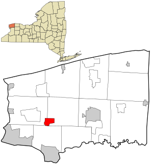
Somerset, New York is a hamlet in the town of Somerset in Niagara County, New York, United States.
West Somerset, New York is a hamlet in the town of Somerset in Niagara County, New York, United States.
South Wilson, New York is a hamlet in the town of Wilson in Niagara County, New York, United States.
Motleys Mill is an unincorporated community in Pittsylvania County, in the U.S. state of Virginia.
Bryantsburg is an unincorporated community in Buchanan County, Iowa, United States. It is located on Highway 150 north of Independence and south of Hazleton, at 42.579132N, -91.905063W.
Dadur is a region of Rio de Janeiro, but not officially recognized as a neighborhood.


