Ransomville, New York

Last updated

Ransomville, New York
CDP
Nicknames: 
Ransomtucky, The Ville
Motto: 
A Great Place To Grow
Niagara County New York incorporated and unincorporated areas Ransomville highlighted.svg
Location in Niagara County and the state of New York.
USA New York location map.svg
Red pog.svg
Ransomville, New York
Coordinates: 43°14′13″N78°54′55″W / 43.23694°N 78.91528°W / 43.23694; -78.91528
Country United States
State New York
County Niagara
Area
[1]
  Total5.90 sq mi (15.29 km2)
  Land5.90 sq mi (15.29 km2)
  Water0.00 sq mi (0.00 km2)
Elevation
325 ft (99 m)
Population
 (2020)
  Total1,316
  Density222.90/sq mi (86.06/km2)
Time zone UTC-5 (Eastern (EST))
  Summer (DST) UTC-4 (EDT)
ZIP code
14131
Area code 716
FIPS code 36-60598
GNIS feature ID0962190
Website https://www.townofporter.net

Ransomville is a hamlet (and census-designated place) located in the Town of Porter in Niagara County, New York, United States. The population was 1,419 at the 2010 census. Portions of the hamlet are also in Town of Wilson and Town of Cambria. Ransomville is north of the City of Niagara Falls and is part of the Buffalo Niagara Falls Metropolitan Statistical Area.

Contents

Ransomville is in the southeast corner of the town on the Youngstown-Lockport Road (New York State Route 93).

Geography

Ransomville is located at 43°14′13″N78°54′55″W / 43.23694°N 78.91528°W / 43.23694; -78.91528 (43.236955, -78.915327). [2]

According to the United States Census Bureau, the CDP has a total area of 6.2 square miles (16 km2), all land.

History

Founding

The town of Ransomville was established in 1842 by the Ransom and Curtiss families and was named after William Henry Harrison Ransom. The Curtiss family, led by brothers Gideon and Capt. Gilbert Curtiss, were the first to settle in the area in the 1820s, establishing the early links with neighboring towns. [3]

The son of immigrants from Sullivan County in the Hudson River Valley, W.H.H. Ransom arrived in Niagara County in 1839 and built a farm that he worked with his wife, Elisa Estes Ransom. In 1846, Ransom purchased a general store from his uncle, Jehiel Ransom, who had been in Niagara County since 1826 and served as postmaster. Ransom had 13 children and died at the age of 74 in Ransomville on December 29, 1889. [4]

Development

Ransomville was established as a farming community, but some of the earliest businesses were the log taverns built by Gideon Curtiss, the first of which was erected in 1817 and the second in 1825. A cemetery was laid out by 1821. In 1840 the Ransomville House was built as a larger, more refined building. In addition to the hotel, an 1860 map of the village lists two doctors and two blacksmiths, as well as a bootmaker, carriage maker, harness maker, grocer, lumber mill and general merchandise store. [5]

Early settlers from the Curtiss family cleared and laid down the roads from Ransomville to Youngstown to the West (NY 93), along the ridge to the South (NY 104) and Lake Ontario to the North (CR 17). In 1876, The Rome, Watertown and Ogdensburg Railroad took over the Lake Ontario Shore Railroad and extended track, connecting Ransomville with Lewiston to the West and Syracuse to the East. This was later incorporated into the New York Central Railroad. [6] A year later, Gilbert Curtiss built the Excelsior Elevator across from the rail depot. The Curtisses' agricultural business would grow to include a poultry farm that was considered the largest in the nation by the early 20th century. [7]

In the 20th century, the town's claim to poultry fame faded with the development of new techniques and the opening of larger facilities. In 1924, the Volunteer Fire Company was formed with 24 charter members and Dr. John C. Plain as its President. A first fire hall was built in 1925 and then replaced by the current facility in 1960. Original equipment included a motorized chemical pumper rig, which replaced the hand-drawn cart. [8] In 1933, Harold Bass opened the Bass Ford Dealership, [9] which was soon joined by Richard Coulter's Chevrolet dealership. [10] In 1954, Ed Ortiz and his brother opened the Ransomville Speedway for dirt track racing. The brothers moved the track outside of town to its current location in 1958. [11]

Demographics

Historical population
CensusPop.Note
2020 1,316
U.S. Decennial Census [12]

As of the census [13] of 2000, there were 1,488 people, 488 households, and 386 families residing in the hamlet. The population density was 240.0 inhabitants per square mile (92.7/km2). There were 504 housing units at an average density of 81.3 per square mile (31.4/km2). The racial makeup of the community was 97.04% White, 1.08% African American, 1.21% Native American, 0.07% Asian, 0.27% from other races, and 0.34% from two or more races. Hispanic or Latino of any race were 0.67% of the population.

There were 488 households, out of which 37.9% had children under the age of 18 living with them, 63.3% were married couples living together, 11.5% had a female householder with no husband present, and 20.7% were non-families. 17.2% of all households were made up of individuals, and 6.8% had someone living alone who was 65 years of age or older. The average household size was 2.82 and the average family size was 3.13.

In the community, the population was spread out, with 24.5% under the age of 18, 9.3% from 18 to 24, 27.2% from 25 to 44, 24.8% from 45 to 64, and 14.1% who were 65 years of age or older. The median age was 38 years. For every 100 females, there were 100.3 males. For every 100 females age 18 and over, there were 98.1 males.

The median income for a household in the village was $48,000, and the median income for a family was $53,239. Males had a median income of $30,833 versus $25,227 for females. The per capita income for the CDP was $22,063. None of the families and 2.8% of the population were living below the poverty line, including no under eighteens and 3.4% of those over 64.

The hamlet is served by the Ransomville Volunteer Fire Company with their station located on NY Route 93 Youngstown-Lockport Road. The Upper Mountain Fire Company of Lewiston, New York provides Advanced Life Support services to Ransomville.

Religion

Despite its small size there are numerous places of worship in Ransomville. [14] These include Ransomville Free Methodist Church, Ransomville United Methodist Church, Fillmore Chapel, Ransomville Baptist Church and Church of the Immaculate Conception.

Notable people

Related Research Articles

<span class="mw-page-title-main">Tuolumne City, California</span> Census-designated place in California, United States

Tuolumne City is an unincorporated town in Tuolumne County, California. A census-designated place (CDP) officially known as Tuolumne also encompasses the town. The population of the CDP was 1,779 at the 2010 census, down from 1,865 at the 2000 census.

<span class="mw-page-title-main">Clarence, New York</span> Town in New York, United States

Clarence is a town and affluent suburb located in the northeastern part of Erie County, New York, United States, northeast of Buffalo. The population was 32,950 according to the 2020 census estimate. This represents an increase of 7.4% from the 2010 census figure. The Clarence census-designated place occupies the southeast part of the town and roughly corresponds to a postal district with ZIP code 14031 and 14221 in the western side which it shares with nearby Williamsville. The town is named in honor of Prince William, Duke of Clarence and St Andrews (1765–1837), the third son of King George III and later king himself, as William IV.

<span class="mw-page-title-main">Newstead, New York</span> Town in New York, United States

Newstead is the northeasternmost town in Erie County, New York, United States. The population was 8,689 at the 2020 census. The name is reportedly derived from Newstead Abbey in England.

<span class="mw-page-title-main">Cambria, New York</span> Town in New York, United States

Cambria is a town in Niagara County, New York, United States. The population was 5,743 at the 2020 census. Cambria is an early name for Wales.

<span class="mw-page-title-main">Pendleton, New York</span> Town in New York, United States

Pendleton is a town on the southern edge of Niagara County, New York, United States. It is east of the city of Niagara Falls and southwest of the city of Lockport. The population was 6,397 at the 2010 census.

<span class="mw-page-title-main">Porter, New York</span> Town in New York, United States

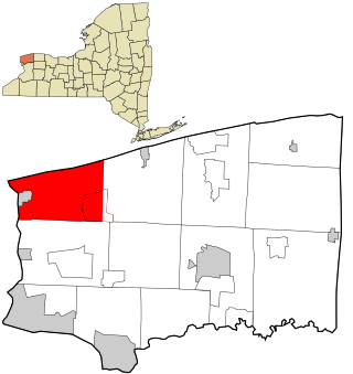
Porter is a town in Niagara County, New York, United States. The population was 6,771 at the 2010 census. The town was named after Judge Augustus Porter.

<span class="mw-page-title-main">Rapids, New York</span> CDP in New York, United States

Rapids is a hamlet located in the Town of Lockport in Niagara County, New York, United States. The population was 1,636 at the 2010 census. The ZIP code for Rapids is 14094.

<span class="mw-page-title-main">Wheatfield, New York</span> Town in New York, United States

Wheatfield is a town in Niagara County, New York, United States. The population was 18,117 at the 2010 census. The name stems from the agricultural use of the town lands, the growing of wheat.

<span class="mw-page-title-main">Youngstown, New York</span> Village in New York, United States

Youngstown is a village in Niagara County, New York, United States. The population was 1,935 at the 2010 census. It is part of the Buffalo–Niagara Falls Metropolitan Statistical Area.

West Bloomfield is a town in Ontario County, New York, United States. The population was 2,760 at the 2020 census.

<span class="mw-page-title-main">Horicon, New York</span> Town in New York, United States

Horicon is a town in Warren County, New York, United States. It is part of the Glens Falls Metropolitan Statistical Area. Horicon's population was 1,389 at the 2010 census.

<span class="mw-page-title-main">Williamson, New York</span> Town in New York, United States

Williamson is a town on the south shore of Lake Ontario in the northwest part of Wayne County, New York, United States. The population was 6,984 at the time of the 2010 census. The town is named after Charles Williamson, a land agent of the Pulteney Estate. Its primary ZIP code is 14589, and telephone exchanges 589 and 904 in area code 315.

<span class="mw-page-title-main">Fort Ransom, North Dakota</span> City in North Dakota, United States

Fort Ransom is a city in Ransom County, North Dakota, United States. The population was 91 at the 2020 census. Fort Ransom was founded in 1880 with the first merchants arriving in 1878.

<span class="mw-page-title-main">Middleburg, Pennsylvania</span> Borough in Pennsylvania, United States

Middleburg is a borough in Snyder County, Pennsylvania, United States. Located in Central Pennsylvania's Susquehanna River Valley, the borough's population was 1,325 at the 2020 census. It is the county seat of Snyder County. Middleburg is part of the Selinsgrove, PA Micropolitan Statistical Area, and is also part of the larger Bloomsburg-Berwick-Sunbury, PA Combined Statistical Area.

<span class="mw-page-title-main">Wilson (village), New York</span> Village in New York, United States

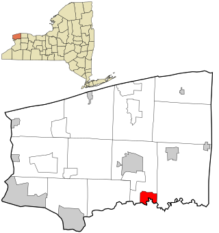
Wilson is a village in Niagara County, New York, United States. The population was 1,264 at the 2010 census. The village is said to be named after Luther Wilson. It is part of the Buffalo–Niagara Falls Metropolitan Statistical Area.

Friendship is a town in Allegany County, New York, United States. The population was 1,960 at the 2020 census. The town's name was adopted to mark the resolution of earlier conflicts.

Hamilton is a town in Madison County, New York, United States. The population was 6,379 at the 2020 census. The town is named after American Founding Father Alexander Hamilton, and is a college town, with Colgate University dominating the town's employment, culture and population.

<span class="mw-page-title-main">Lewiston, New York</span> Town in New York, United States

Lewiston is a town in Niagara County, New York, United States. The population was 15,944 at the 2020 census. The town and its contained village are named after Morgan Lewis, a governor of New York.

<span class="mw-page-title-main">Wilson, New York</span> Town in New York, United States

Wilson is a town in Niagara County, New York, United States. The population was 5,993 at the 2010 census. The town was named after an early settler, Reuben Wilson, who built and dwelt in a log cabin on the shore of Lake Ontario at the site of what would become the Village of Wilson.

<span class="mw-page-title-main">Clarence (CDP), New York</span> Census-designated place in New York, United States

Clarence is a hamlet and census-designated place (CDP) within the town of Clarence in Erie County, New York, United States. The population was 2,646 at the 2010 census.

References

  1. "ArcGIS REST Services Directory". United States Census Bureau. Retrieved September 20, 2022.
  2. "US Gazetteer files: 2010, 2000, and 1990". United States Census Bureau. February 12, 2011. Retrieved April 23, 2011.
  3. "Niagara County Historical Society's Bicentennial Moments - The Niagara Poultry Farm of Ransomville." Niagara County Historical Society. Retrieved on October 22, 2012.
  4. "Niagara County Historical Society's Bicentennial Moments - The Ransom Family." Niagara County Historical Society. Retrieved on October 22, 2012.
  5. 1860 Ransomville Niagara County, NYGenWeb Project. Retrieved October 22, 2012.
  6. Rome Watertown & Ogdensburg Railroad - History by Harold Russell Harold Russell. Retrieved October 22, 2012.
  7. Niagara County Historical Society's Bicentennial Moments - The Niagara Poultry Farm of Ransomville Niagara County Historical Society. Retrieved October 22, 2012.
  8. History of Ransomville Volunteer Fire Company Ransomville Volunteer Fire Company. Retrieved October 24, 2012.
  9. HAROLD C. BASS, OWNED FORD AGENCY - The Buffalo News Highbeam Research. Retrieved October 24, 2012
  10. Richard C. Courter, auto dealer and marina operator ; Nov. 4, 1917 -- Nov. 15, 2007 - The Buffalo News Highbeam Research. Retrieved October 24, 2012
  11. Ransomville Speedway Archived 2012-03-10 at the Wayback Machine June Boone. Stock Car Racing. February 2009. Retrieved October 24, 2012.
  12. "Census of Population and Housing". Census.gov. Retrieved June 4, 2016.
  13. "U.S. Census website". United States Census Bureau . Retrieved January 31, 2008.
  14. "Map of Ransomville." Google Maps. Retrieved 2008-01-27.