South Swale

Last updated
South Swale
South Bank of Swale Nature Reserve - geograph.org.uk - 96184.jpg
Type Local Nature Reserve
Location Faversham, Kent
OS grid TR 047 653
Area 410.5 hectares (1,014 acres)
Managed by Kent Wildlife Trust

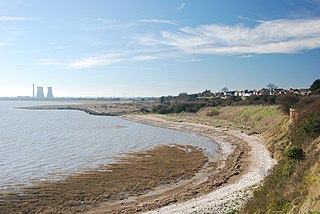
South Swale is a 410.5-hectare (1,014-acre) Local Nature Reserve (as South Bank of the Swale) north of Faversham in Kent. It is owned by Kent County Council and managed by Kent Wildlife Trust. [1] [2] [3] It is part of The Swale Ramsar site, [4] Special Protection Area [5] and Site of Special Scientific Interest [6]

Faversham town in the English county of Kent

Faversham is a market town and civil parish in the Swale district of Kent, England, United Kingdom. The town is 48 miles from London and 10 miles from Canterbury and lies next to the Swale, a strip of sea separating mainland Kent from the Isle of Sheppey in the Thames Estuary. It is close to the A2, which follows an ancient British trackway which was used by the Romans and the Anglo-Saxons, and known as Watling Street. The Faversham name is of Latin via Old English origin, meaning "the metal-worker's village".

Kent County of England

Kent is a county in South East England and one of the home counties. It borders Greater London to the north west, Surrey to the west and East Sussex to the south west. The county also shares borders with Essex along the estuary of the River Thames, and with the French department of Pas-de-Calais through the Channel Tunnel. The county town is Maidstone.

Kent County Council British administrative authority

Kent County Council is a county council that governs most of the county of Kent in England. It is the upper tier of elected local government, below which are 12 district councils, and around 300 town and parish councils. The county council has 84 elected councillors. The chief executive and chief officers are responsible for the day-to-day running of the council. Paul Carter is the leader of the council. Kent County Council is currently controlled by the Conservative Party and the official opposition is the Liberal Democrats with 7 seats. It is one of the largest local authorities in England in terms of population served and the largest local authority of its type.

This coastal site has wetland and grassland, with mudflats which attract a large population of waders and wildfowl in winter. Flora include Yellow horned-popies, sea-lavender, golden samphires and wild carrots. [3]

<i>Glaucium flavum</i> species of plant

Glaucium flavum is a summer flowering plant in the Papaveraceae family. It is native to Northern Africa, Macronesia, temperate zones in Western Asia and the Caucasus, as well as Europe. The plant grows on the seashore and is never found inland. All parts of the plant, including the seeds, are toxic. It is classed as a noxious weed, in some areas of North America, where it is an introduced species. It is grown in gardens as a short-lived perennial but usually grown as a biennial.

Golden samphire species of plant, golden samphire

The golden samphire is a perennial coastal species, which may be found growing on salt marsh or sea cliffs across western and southern Europe and the Mediterranean.

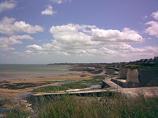
The Saxon Shore Way public footpath follows the top of the sea wall for the entire length of the reserve, around the village of Graveney, for about 3 miles in total. [7]

Saxon Shore Way

The Saxon Shore Way is a long-distance footpath in England. It starts at Gravesend, Kent, and traces the coast of South-East England as it was in Roman times (note the changed coastline around Romney Marsh) as far as Hastings, East Sussex, 163 miles (262 km) in total.

Graveney village in United Kingdom

Graveney is a relatively small but widely dispersed village located between Faversham and Whitstable in Kent, England. The main part of the village is located along the intersection of Seasalter Road, Sandbanks Road and Head Hill Road, which is surrounded by farmland. The rest of the village is dispersed amongst this farmland.

See also

Oare Marshes

Oare Marshes is a 71.4-hectare (176-acre) Local Nature Reserve north of Faversham in Kent. It is owned and managed by Kent Wildlife Trust. It is part of The Swale Nature Conservation Review site, Grade I, National Nature Reserve, Ramsar internationally important wetland site, Special Protection Area under the European Union Directive on the Conservation of Wild Birds, and Site of Special Scientific Interest.

Related Research Articles

Kent Wildlife Trust organization

Kent Wildlife Trust (KWT) is a conservation charity in the United Kingdom that was founded in 1958, previously known as the Kent Trust for Nature Conservation. It aims to "work with people to restore, save and improve our natural spaces" and to "ensure that 30% of Kent and Medway - land and sea - is managed to create a healthy place for wildlife to flourish". In 2016 it had thirty-one thousand members and an annual income of £4 million. KWT manages fifty-four nature reserves, of which twenty-four are Sites of Special Scientific Interest, two are National Nature Reserves, nine are Nature Conservation Review sites, seven are Special Areas of Conservation, three are Special Protection Areas, seven are Local Nature Reserves, one is a Geological Conservation Review site, thirteen are in Areas of Outstanding Natural Beauty and one is a Scheduled Monument.

The Swale channel in the Thames estuary

The Swale is a tidal channel of the Thames estuary that separates the Isle of Sheppey from the rest of Kent. On its banks is a 6,509.4-hectare (16,085-acre) biological Site of Special Scientific Interest which stretches from Sittingbourne to Whitstable in Kent. It is also a Ramsar internationally important wetland site and a Special Protection Area under the European Union Directive on the Conservation of Wild Birds. Parts of it are a Nature Conservation Review site, Grade I, National Nature Reserves, a Kent Wildlife Trust nature reserve and a Local Nature Reserve.

Sussex Wildlife Trust organization

The Sussex Wildlife Trust is a wildlife trust and a registered charity covering the counties of East Sussex and West Sussex, England. The Trust's Chief Executive is Tor Lawrence who succeeds Tony Whitbread.

Queendown Warren

Queendown Warren is a 22.2-hectare (55-acre) biological Site of Special Scientific Interest south-east of Rainham in Kent. It is a Local Nature Reserve, a Nature Conservation Review site, Grade 2, and a Special Area of Conservation.. It is in the Kent Downs Area of Outstanding Natural Beauty. It is managed by the Kent Wildlife Trust, and part of it is owned by Plantlife.

Lydden and Temple Ewell Downs

Lydden and Temple Ewell Downs is a 63.2-hectare (156-acre) biological Site of Special Scientific Interest north-west of Dover in Kent. It is a Special Area of Conservation and Nature Conservation Review site. It is also part of the 78.5-hectare (194-acre) Lydden Temple Ewell National Nature Reserve and the 90-hectare (220-acre) Lydden Temple Ewell nature reserve, which is managed by the Kent Wildlife Trust. It is in the South Downs Area of Outstanding Natural Beauty.

Sandwich Bay to Hacklinge Marshes

Sandwich Bay to Hacklinge Marshes is a 1,790.1-hectare (4,423-acre) biological and geological Site of Special Scientific Interest which stretches between Deal and Sandwich in Kent. It includes two Geological Conservation Review sites, and most of it is a Nature Conservation Review site, Grade I. Part of it is a Ramsar site, a Special Area of Conservation, a Special Protection Area and a National Nature Reserve, It also includes a Kent Wildlife Trust nature reserve and a Local Nature Reserve,

Stodmarsh SSSI

Stodmarsh SSSI is a 623.2-hectare (1,540-acre) biological Site of Special Scientific Interest near Stodmarsh, north-east of Canterbury in Kent. Parts of it are a Nature Conservation Review site, Grade I. a National Nature Reserve, a Ramsar internationally important wetland site, a Special Area of Conservation and a Special Protection Area under the European Union Directive on the Conservation of Wild Birds.

Thanet Coast

Thanet Coast is an 816.9-hectare (2,019-acre) biological and geological Site of Special Scientific Interest which stretches along the coast between Whitstable and Ramsgate in Kent. It is a Geological Conservation Review site, and overlaps two Special Area of Conservations. It is also part of a Ramsar Site and a Special Protection Area. Part of it is a Local Nature Reserve,

Princes Beachlands

Prince's Beachlands is a 6-hectare (15-acre) Local Nature Reserve north of Sandwich in Kent. It is owned by Dover Town Council and managed by Kent Wildlife Trust as part of the Sandwich Bay to Hacklinge Marshes nature reserve. It is part of the Sandwich and Pegwell Bay Nature Conservation Review site, Grade I, Thanet Coast and Sandwich Bay Ramsar site, Sandwich Bay Special Area of Conservation, Thanet Coast and Sandwich Bay Special Protection Area and Sandwich Bay to Hacklinge Marshes Site of Special Scientific Interest.

Seasalter Levels

Seasalter Levels is a 71.4-hectare (176-acre) Local Nature Reserve in Seasalter, on the western outskirts of Whitstable in Kent. It is owned and managed by Canterbury City Council. It is part of The Swale Ramsar site, Special Protection Area and Site of Special Scientific Interest.

Sandwich and Pegwell Bay

Sandwich and Pegwell Bay is a 615-hectare (1,520-acre) nature reserve Kent, managed by the Kent Wildlife Trust. It is a National Nature Reserve, and it includes a Geological Conservation Review site, Prince's Beachlands Local Nature Reserve and two Special Areas of Conservation, Sandwich Bay and Thanet Coast. It is part of Sandwich Bay and Thanet Coast Ramsar site and Special Protection Area. It is also of Sandwich Bay to Hacklinge Marshes Site of Special Scientific Interest and Sandwich/Pegwell Bay Nature Conservation Review site, Grade I.

Bure Broads and Marshes

Bure Broads and Marshes is a 741.1-hectare (1,831-acre) biological Site of Special Scientific Interest north-east of Norwich in Norfolk. Most of it is a Nature Conservation Review site, Grade I and National Nature Reserve. Two areas are nature reserves managed by the Norfolk Wildlife Trust, Cockshoot Broad and Ranworth Broad. It is part of the Broadland Ramsar site and Special Protection Area and The Broads Special Area of Conservation,

Oare Meadow

Oare Meadow is a 2-hectare (4.9-acre) nature reserve in Oare, north of Faversham in Kent. It is managed by the Kent Wildlife Trust. It is part of The Swale Site of Special Scientific Interest.

Rye Harbour LNR

Rye Harbour LNR is a 325.4-hectare (804-acre) Local Nature Reserve in Rye in East Sussex. The site is part of the 465-hectare (1,150-acre) nature reserve managed by the Sussex Wildlife Trust. It is also part of Dungeness, Romney Marsh and Rye Bay Ramsar site, Special Protection Area and Site of Special Scientific Interest and Dungeness Special Area of Conservation.

References

  1. "South Bank of the Swale". Local Nature Reserves. Natural England. Retrieved 7 March 2018.
  2. "Map of South Bank of the Swale". Local Nature Reserves. Natural England. Retrieved 7 March 2018.
  3. 1 2 "South Swale". Kent Wildlife Trust. Retrieved 26 January 2018.
  4. "Designated Sites View: The Swale". Ramsar Site. Natural England. Retrieved 22 January 2018.
  5. "Designated Sites View: The Swale". Special Protection Area. Natural England. Retrieved 22 January 2018.
  6. "Designated Sites View: The Swale". Sites of Special Scientific Interest. Natural England. Retrieved 22 January 2018.
  7. http://www.faversham.org/pages/standard.aspx?i_PageID=1176 Archived September 10, 2011, at the Wayback Machine .

Coordinates: 51°21′00″N0°56′17″E / 51.35°N 0.938°E / 51.35; 0.938

Geographic coordinate system Coordinate system

A geographic coordinate system is a coordinate system that enables every location on Earth to be specified by a set of numbers, letters or symbols. The coordinates are often chosen such that one of the numbers represents a vertical position and two or three of the numbers represent a horizontal position; alternatively, a geographic position may be expressed in a combined three-dimensional Cartesian vector. A common choice of coordinates is latitude, longitude and elevation. To specify a location on a plane requires a map projection.