The Llangollen Canal is a navigable canal crossing the border between England and Wales. The waterway links Llangollen in Denbighshire, north Wales, with Hurleston in south Cheshire, via the town of Ellesmere, Shropshire. The name, which was coined in the 1980s, is a modern designation for parts of the historic Ellesmere Canal and the Llangollen navigable feeder, both of which became part of the Shropshire Union Canals in 1846.

Chirk is a town and local community in the Wrexham County Borough, Wales. Historically in the traditional county of Denbighshire, it is now administered as part of the wider Wrexham County Borough. In the 2011 census, it had a population of 4,468. It is located 10 miles south of Wrexham.
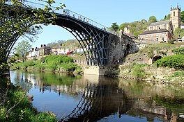
Coalbrookdale is a village in the Ironbridge Gorge in Shropshire, England, containing a settlement of great significance in the history of iron ore smelting. It lies within the civil parish called the Gorge.

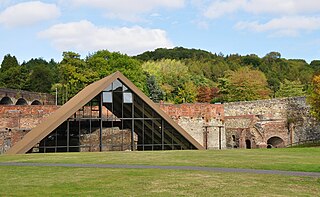
Blists Hill Victorian Town is an open-air museum built on a former industrial complex located in the Madeley area of Telford, Shropshire, England. The museum attempts to recreate the sights, sounds and smells of a Victorian Shropshire town in the late 19th and early 20th centuries. It is one of ten museums operated by the Ironbridge Gorge Museum Trust.

Dawley is a town in the borough of Telford and Wrekin and ceremonial county of Shropshire, England. Today, it forms part of Telford, which was originally, in 1963, going to be named 'Dawley New Town' before it was decided in 1968 to name the town 'Telford', after the engineer and road-builder Thomas Telford.

Madeley is a town and civil parish in Shropshire, England, now part of Telford. The parish had a population of 17,935 at the 2001 census.
The Shrewsbury Canal was a canal in Shropshire, England. Authorised in 1793, the main line from Trench to Shrewsbury was fully open by 1797, but it remained isolated from the rest of the canal network until 1835, when the Birmingham and Liverpool Junction Canal built the Newport Branch from Norbury Junction to a new junction with the Shrewsbury Canal at Wappenshall. After ownership passed to a series of railway companies, the canal was officially abandoned in 1944; many sections have disappeared, though some bridges and other structures can still be found. There is an active campaign to preserve the remnants of the canal and to restore the Norbury to Shrewsbury line to navigation.

Blaenavon Industrial Landscape, in and around Blaenavon, Torfaen, Wales, was inscribed a World Heritage Site by UNESCO in 2000. The Blaenavon Ironworks, now a museum, was a major centre of iron production using locally mined or quarried iron ore, coal and limestone. Raw materials and products were transported via horse-drawn tramroads, canals and steam railways. The Landscape includes protected or listed monuments of the industrial processes, transport infrastructure, workers' housing and other aspects of early industrialisation in South Wales.

Bradford is a district of east Manchester, England, two miles north east of the city centre. The population at the 2011 census was 15,784. Historically in Lancashire, after the closure of its heavy industries Bradford was for many years an economically deprived area but has undergone regeneration with the building of the City of Manchester Stadium which hosted the 2002 Commonwealth Games and is now home to Manchester City F.C.. Bradford is neighboured by Beswick to the south and the two areas are sometimes referred to as Bradford-with-Beswick. The River Medlock and the Ashton Canal run through Bradford.

Telford Town Park is a park and Local Nature Reserve in Telford in Shropshire. In 2015, it was voted "UK's Best Park" in the inaugural public competition organised by Fields in Trust

Stirchley is a large village and suburb of the new town of Telford, in the borough of Telford and Wrekin and ceremonial county of Shropshire, England. Stirchley lies just south-east of the town centre, and shares a parish council with neighbouring Brookside, which together have a population of 10,533 according to the 2001 census data It is close to Dawley and Malinslee and located next to the southern side of Telford town park. Although formerly a farming parish, it was incorporated into the Telford New Town in the 1970s. There are some important heritage sites in the parish, notably St James Church, Stirchley Hall, Stirchley Grange and the Stirchley Chimney, now a local landmark. A number of Stirchley's heritage sites are waypoints on the South Telford Heritage Trail. The former school was removed brick-by-brick and rebuilt at the nearby Blists Hill Victorian Town museum in 1993.
The BCN Main Line, or Birmingham Canal Navigations Main Line describes the evolving route of the Birmingham Canal between Birmingham and Wolverhampton in England.

The Shropshire Canal was a tub boat canal built to supply coal, ore and limestone to the industrial region of east Shropshire, England, that adjoined the River Severn at Coalbrookdale. It ran from a junction with the Donnington Wood Canal ascending the 316 yard long Wrockwardine Wood inclined plane to its summit level, it made a junction with the older Ketley Canal and at Southall Bank the Coalbrookdale (Horsehay) branch went to Brierly Hill above Coalbrookdale; the main line descended via the 600 yard long Windmill Incline and the 350 yard long Hay Inclined Plane to Coalport on the River Severn. The short section of the Shropshire Canal from the base of the Hay Inclined Plane to its junction with the River Severn is sometimes referred to as the Coalport Canal.

The Aberdare Canal was a canal in Glamorgan, Wales which ran from Aberdare to a junction with the Glamorganshire Canal at Abercynon. It opened in 1812, and served the iron and coal industries for almost 65 years. The arrival of railways in the area did not immediately affect its traffic, but the failure of the iron industry in 1875 and increasing subsidence due to coal mining led to it becoming uneconomic. The Marquess of Bute failed to halt its decline when he took it over in 1885, and in 1900 it was closed on safety grounds. The company continued to operate a tramway until 1944. Most of the route was buried by the construction of the A4059 road in 1923, although a short section at the head of the canal remains in water and is now a nature reserve. The company was wound up in 1955.

The Stourbridge Extension Canal was a short canal built to serve a number of mines in the Kingswinford area of Staffordshire in England. Although connected to the Stourbridge Canal, it was independent from it. It opened in 1840, and was abandoned in 1935. A short section of it is still used as moorings for boats using the Stourbridge Canal.

St James' Church is a redundant Anglican church in Stirchley, Shropshire, England. Stirchley was formerly a separate village but is now part of the new town of Telford. The church is recorded in the National Heritage List for England as a designated Grade I listed building, and is under the care of the Churches Conservation Trust. The churchyard is designated as a Scheduled ancient monument.

The Coalport branch line was a standard gauge London and North Western Railway branch line in Shropshire, England, which ran between Hadley Junction near Oakengates on the Stafford to Shrewsbury line and a terminus at Coalport East railway station on the north bank of the River Severn at Coalport.

The Pensnett Canal, also called Lord Ward's Canal was a private 1.25 miles (2 km) long canal near Brierley Hill, West Midlands, England, which opened in 1840 and served the industrial enterprises of Lord Dudley's Estate. The engineer was Mathew Frost. Since its closure to navigation in 1950, much of it has been lost by overbuilding, but a small section at its junction with the Dudley Canal was restored in 1995, and the section through Brierley Hill remains in water, although it is polluted and not navigable.

Brookside is a housing estate and borough and parish council ward in Telford, Shropshire, England. The original settlement of Brookside is a Radburn estate built in the early 1970s as part of the development of Telford New Town and is entirely within the confines of Brookside Avenue, a 1.7 mile ring road. Significant development has taken place around the outside of Brookside Avenue since the estate was built, the majority of which is part of Stirchley Park but falls within the Brookside ward for both Telford and Wrekin Council and Stirchley and Brookside Parish Council.

Stirchley Chimney is a chimney located in Telford Town Park. The chimney also marks a notable waypoint on the South Telford Heritage Trail. Measuring 209 feet (64 m) high, construction of the chimney was completed in 1873.