The Southern Mistbelt Forest is a vegetation type in South Africa.
Contents

The Southern Mistbelt Forest is a vegetation type in South Africa.
KwaZulu-Natal and Eastern Cape Provinces.
Forest patches in high-rainfall, fire-protected habitats on steep south-facing slopes. Altitudes range from 850 to 1 600 m, and mean annual rainfall generally exceeds 900 mm.
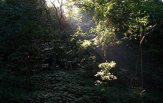
In the Amathole Mountains and the KwaZulu-Natal Midlands, and on the Transkei Escarpment, these forests are characterized by their tall stature, reaching heights of 15–20 meters. They have a complex structure, with two layers of trees, a dense shrubby understorey, and a well-developed herb layer. On the low-altitude scarps, the forests are shorter and resemble scrub forests in some areas, but they are still home to a diverse range of species. While the tall forests exhibit a mix of coarse-grained dynamics driven by canopy gaps and disturbances, as well as fine-grained regeneration characteristics, the mistbelt forests in the Amathole region are primarily dominated by emergent trees such as Afrocarpus falcatus , along with various deciduous and semi-deciduous species including Celtis africana , Calodendrum capense , Vepris lanceolata , and Zanthoxylum davyi . In Transkei and the KwaZulu-Natal Midlands, Podocarpus henkelii becomes more prominent in the canopy layer. Deciduous species play a significant role in these forests. [1]
Some of the soils are deep loams and clays, developed on weathered dolerite intrusions or mudstones, shales and sandstones of the Karoo Supergroup; Their topsoils often have high concentrations of organic matter, which release sufficient nutrients for high productivity. The soils underlying lower-altitude forests that developed on more quartzitic rocks are shallower and less fertile. [1]
About 8% of these forests are protected. In the Eastern Cape this includes parts of the Bosberg Nature Reserve, Greater Addo Elephant National Park, and Hogsback, Kologha, Isidenge, Kubusi, Katberg and Nabakyu State Forests. In KwaZulu-Natal they are protected in Impendle, Igxalingenwa, Karkloof and Qudeni Nature Reserves. Smaller forest patches are protected on private land. About 5% has been transformed for plantations. Invasive aliens include . Major threats include invasive alien plants (including Solanum mauritianum , and Rubus , Acacia , and Eucalyptus species), overexploitation of timber (for building and firewood) and non-timber forest products (for herbal medicines and livestock feed) together with mismanagement of fire and burning regimes in surrounding grasslands. [1]

South Africa occupies the southern tip of Africa, its coastline stretching more than 2,850 kilometres from the desert border with Namibia on the Atlantic (western) coast southwards around the tip of Africa and then northeast to the border with Mozambique on the Indian (eastern) coast. The low-lying coastal zone is narrow for much of that distance, soon giving way to a mountainous escarpment that separates the coast from the high inland plateau. In some places, notably the province of KwaZulu-Natal in the east, a greater distance separates the coast from the escarpment. Although much of the country is classified as semi-arid, it has considerable variation in climate as well as topography. The total land area is 1,220,813 km2 (471,359 sq mi). It has the 23rd largest Exclusive Economic Zone of 1,535,538 km2 (592,875 sq mi).

The Maputaland-Pondoland bushland and thickets is one of the ecoregions of South Africa. It consists of the montane shrubland biome.

The Kwazulu-Cape coastal forest mosaic is a subtropical moist broadleaf forest ecoregion of South Africa. It covers an area of 17,800 square kilometers (6,900 sq mi) in South Africa's Eastern Cape and KwaZulu-Natal provinces.

The Coastal forests of eastern Africa, also known as the East African Coastal Forests or Zanzibar–Inhambane forests, is a tropical moist forest region along the east coast of Africa. The region was designated a biodiversity hotspot by Conservation International.

The Cape parrot or Levaillant's parrot is a large, temperate forest dwelling parrot of the genus Poicephalus endemic to South Africa. It was formerly grouped as a subspecies along with the savanna-dwelling brown-necked parrot and grey-headed parrot, but is now considered a distinct species.

The Umtamvuna Nature Reserve is situated in South Africa on the KwaZulu-Natal side of the Mtamvuna River, and is managed by Ezemvelo KZN Wildlife. The reserve is 3,257 hectares in extent and was established on 25 July 1971.

Mabi forests are a type of ecological community found in the Australian state of Queensland which is considered to be critically endangered and which consists of remnant patches found only either in North Queensland's Atherton Tablelands or at Shiptons Flat along the Annan River.
Areas of forest which grow in KwaZulu-Natal, South Africa mostly on south facing slopes in higher rainfall areas, and along the humid coastal areas. Different types of forest can be identified by their species composition which depends mostly on the altitude, latitude and substrate in which they grow. South facing slopes are favourable for the development of forest as they are more shaded, and therefore cooler and retain more moisture than the northern slopes. The extra moisture on the south slopes is not only favoured by forest trees, but also helps to prevent or subdue wildfires. Fires can also be blocked by cliff faces and rocks or boulders on these slopes, and by streams or rivers at the base of the slopes. The coastal regions are conducive to forest formation, because of high rainfall and humidity which are favoured by forest trees and also help to prevent or subdue fires. The rivers of the coastal areas are also broader than further inland, which may often prevent fires from spreading long distances, and fires generally burn uphill and therefore more often away from areas at low altitude.

The Karkloof Forest is situated in the Karkloof Nature Reserve, 22 km north of Howick, KwaZulu-Natal, South Africa.
The Weza Forest is also known as the Weza-Ngele Forest and is situated near Harding, KwaZulu-Natal, South Africa. This is a large Mistbelt Forest which has long been exploited for timber. The forest has been fragmented and reduced in size over many decades.

The Maputaland-Pondoland-Albany Hotspot (MPA) is a biodiversity hotspot, a biogeographic region with significant levels of biodiversity, in Southern Africa. It is situated near the south-eastern coast of Africa, occupying an area between the Great Escarpment and the Indian Ocean. The area is named after Maputaland, Pondoland and Albany. It stretches from the Albany Centre of Plant Endemism in the Eastern Cape Province of South Africa, through the Pondoland Centre of Plant Endemism and KwaZulu-Natal Province, the eastern side of Eswatini and into southern Mozambique and Mpumalanga. The Maputaland Centre of Plant Endemism is contained in northern KwaZulu-Natal and southern Mozambique.

Millettia grandis is a species of plant in the family Fabaceae from South Africa. It is commonly called umzimbeet which is a name derived from the isiZulu name umSimbithwa.
KwaZulu-Natal Dune Forest is a subtropical forest type that was once found almost continuously along the coastal dunes of KwaZulu-Natal, South Africa. This vegetation type develops in sheltered areas behind the littoral zone, where with some protection from the salt wind it may develop with canopies as tall as 30 m. It still exists in protected areas, but much has been degraded by human activity. Coastal dune forest covers approximately 1% of the land area of KwaZulu-Natal, and is a habitat type seriously threatened from human population pressure and development, particularly titanium mining.

Mimusops caffra is a species of tree in family Sapotaceae. This tree is found in coastal dune vegetation in Southern Africa from the Eastern Cape, through KwaZulu-Natal to southern Mozambique.
Apallaga mokeezi, also known as the large sprite, large flat or Christmas forester, is a species of butterfly in the family Hesperiidae. It is found in South Africa and Mozambique. The habitat consists coastal forests and montane forests.
Marutswa Forest is an indigenous mist-belt forest near Bulwer in the Midlands of KwaZulu-Natal region of South Africa.
Dalbergia obovata is a robust shrub or climber in the family Fabaceae, and is native to Southern Africa.

Southern Afrotemperate Forest is a kind of tall, shady, multilayered indigenous South African forest. This is the main forest-type in the south-western part of South Africa, naturally extending from the Cape Peninsula in the west, as far as Port Elizabeth in the east. In this range, it usually occurs in small forest pockets, surrounded by fynbos vegetation.
The Indian Ocean coastal belt is one of the nine recognised biomes of South Africa. They are described in terms of their vegetation and climatic variations.