Southern New Guinea lowland rain forests

Last updated
Southern New Guinea lowland rain forests
Wikiearth-Danau Habema Taman Nasional Lorentz.jpg
Ecoregion AA0122.png
Ecoregion territory (in purple)
Ecology
Realm Australasian realm
Biome tropical and subtropical moist broadleaf forests
Borders
Geography
Area122,335 km2 (47,234 sq mi)
Countries
Provinces
Coordinates 6°06′S140°12′E / 6.1°S 140.2°E / -6.1; 140.2
Conservation
Conservation status Critical/endangered
Protected5,841 km2 (5%) [1]

The Southern New Guinea lowland rain forests is a tropical moist forest ecoregion in southeastern New Guinea. The ecoregion covers portions of New Guinea's southern lowlands. [2] [3] [4]

Contents

Geography

The ecoregion includes the foothills and lowlands south of New Guinea's Central Range. Above 1000 meters elevation, the lowland forests transition to the Central Range montane rain forests. The Southern New Guinea freshwater swamp forests ecoregion covers extensive areas of the Fly River lowlands to the south, and the lower reaches of some other rivers that drain from the highlands to the sea. The Trans-Fly savanna and grasslands cover the southern tip of New Guinea. [5]

Climate

The ecoregion has a humid tropical climate. The slopes of the Central Range above 100 meters elevation include some of the rainiest portions of New Guinea. [6]

Flora

Broadleaf evergreen rain forests cover most of the ecoregion. Alluvial forests lie in the plains, and hill forests cover the foothills of the Central Range. There are smaller areas of semi-evergreen forest, swamp forest, and savanna. [7]

Fauna

The ecoregion has 69 species of mammals, principally marsupials, bats, and murid rodents. There are no strict endemic species. There are 344 species of birds in the ecoregion. [8]

The largest bird in the ecoregion is the flightless southern cassowary (Casuarius casuarius). [9]

Protected areas

A 2017 assessment found that 5,841 km2, or 5%, of the ecoregion is in protected areas. About three-quarters of the ecoregion is still forested. [10]

Related Research Articles

<span class="mw-page-title-main">North Western Ghats moist deciduous forests</span> Ecoregion in India

The North Western Ghats moist deciduous forests is a tropical moist broadleaf forest ecoregion of southwestern India.

<span class="mw-page-title-main">Northern dry deciduous forests</span> Ecoregion of India

The Northern dry deciduous forests, presently known as the North Deccan dry deciduous forests, is a tropical dry broadleaf forest ecoregion of east-central India.

<span class="mw-page-title-main">Northern New Guinea lowland rain and freshwater swamp forests</span> Ecoregion in New Guinea

The Northern New Guinea lowland rain and freshwater swamp forests is a tropical moist broadleaf forest ecoregion of northern New Guinea.

<span class="mw-page-title-main">Mizoram–Manipur–Kachin rain forests</span> Ecoregion in Indochina

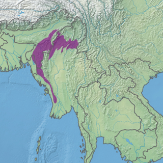
The Mizoram–Manipur–Kachin rain forests is a subtropical moist broadleaf forest ecoregion which occupies the lower hillsides of the mountainous border region joining Bangladesh, China's Yunnan Province, India, and Myanmar. The ecoregion covers an area of 135,600 square kilometres (52,400 sq mi). Located where the biotas of the Indian Subcontinent and the Indochinese Peninsula meet, and in the transition between subtropical and tropical regions of Asia, the Mizoram–Manipur–Kachin rain forests are home to great biodiversity. The WWF rates the ecoregion as "Globally Outstanding" in biological distinctiveness.

<span class="mw-page-title-main">Halmahera rain forests</span> Ecoregion in Halmahera, Indonesia

The Halmahera rain forests is a tropical moist forest ecoregion in Indonesia. The ecoregion includes the island of Halmahera and neighboring islands, including Bacan, Morotai, the Obi Islands, Ternate, Tidore, Gebe, and many smaller islands.

<span class="mw-page-title-main">Timor and Wetar deciduous forests</span> Ecoregion in Indonesia and East Timor

The Timor and Wetar deciduous forests is a tropical dry forest ecoregion in Indonesia and East Timor. The ecoregion includes the islands of Timor, Wetar, Rote, Savu, and adjacent smaller islands.

<span class="mw-page-title-main">Tenasserim–South Thailand semi-evergreen rain forests</span> Ecoregion on Mainland Southeast Asia

The Tenasserim–South Thailand semi-evergreen rain forests is a tropical moist broadleaf forest ecoregion on Mainland Southeast Asia. The ecoregion extends north–south along the Kra Isthmus. It includes lowland forests along the coasts, and montane forests on the Tenasserim Hills and Bilauktaung range, which form the mountainous spine of the isthmus.

<span class="mw-page-title-main">Peninsular Malaysian rain forests</span> Ecoregion on the Malay Peninsula

The Peninsular Malaysian rain forests is an ecoregion on the Malay Peninsula and adjacent islands. It is in the tropical and subtropical moist broadleaf forests biome.

<span class="mw-page-title-main">Irrawaddy moist deciduous forests</span> Ecoregion in Myanmar

The Irrawaddy moist deciduous forests is a tropical moist broadleaf forest ecoregion in central Myanmar. The ecoregion occupies the central basin of the Irrawaddy River and the lower basin of the Salween River. The ecoregion is characterized by forests of tall trees which drop their leaves in the dry season. Most of the ecoregion's forests have been converted to agriculture.

<span class="mw-page-title-main">Kayah–Karen montane rain forests</span> Ecoregion on Mainland Southeast Asia

The Kayah–Karen montane rain forests is a tropical moist broadleaf forest ecoregion on Mainland Southeast Asia. The montane rain forests cover several connected mountain ranges, including the Daen Lao Range, the Dawna Range, the Karen Hills, the Khun Tan Range, and the Thanon Thong Chai Range.

<span class="mw-page-title-main">Chao Phraya lowland moist deciduous forests</span> Ecoregion in Central Thailand

The Chao Phraya lowland moist deciduous forests is a tropical moist broadleaf forest ecoregion in Thailand. The ecoregion occupies the coastal lowlands along the Gulf of Thailand lying east and west of the Chao Phraya River.

<span class="mw-page-title-main">Seram rain forests</span> Ecoregion in Seram, Indonesia

The Seram rain forests is a tropical moist forest ecoregion in Indonesia. The ecoregion includes the island of Seram and neighboring islands.

<span class="mw-page-title-main">Sulawesi lowland rain forests</span> Ecoregion in Sulawesi, Indonesia

The Sulawesi lowland rain forests is a tropical moist forest ecoregion in Indonesia. The ecoregion includes the lowlands of Sulawesi and neighboring islands.

<span class="mw-page-title-main">Sulawesi montane rain forests</span> Ecoregion in Sulawesi, Indonesia

The Sulawesi montane rain forests is a tropical moist forest ecoregion in Indonesia. It includes the highlands of Sulawesi.

<span class="mw-page-title-main">Vogelkop–Aru lowland rain forests</span> Ecoregion in Indonesia

The Vogelkop–Aru lowland rain forests is a tropical moist forest ecoregion in Indonesia. The ecoregion covers the peninsular lowlands of western New Guinea, along with the Aru Islands and other nearby islands.

<span class="mw-page-title-main">Vogelkop montane rain forests</span> Ecoregion in New Guinea

The Vogelkop montane rain forests is a tropical moist forest ecoregion in western New Guinea. The ecoregion covers the mountains of western New Guinea's Bird's Head and Bomberai peninsulas.

<span class="mw-page-title-main">New Britain–New Ireland lowland rain forests</span>

The New Britain-New Ireland lowland rain forests is a tropical moist forest ecoregion in Papua New Guinea. The ecoregion covers the lowland rain forests of New Britain, New Ireland, and nearby islands in the Bismarck Archipelago.

<span class="mw-page-title-main">Northern New Guinea montane rain forests</span> Ecoregion in New Guinea

The Northern New Guinea montane rain forests is a tropical moist forest ecoregion in northern New Guinea. The ecoregion covers several separate mountain ranges lying north of New Guinea's Central Range and south of the Pacific Ocean.

<span class="mw-page-title-main">Southeastern Papuan rain forests</span>

The Southeastern Papuan rain forests is a tropical moist forest ecoregion in southeastern New Guinea. The ecoregion covers the mountainous center and coastal lowlands of the Papuan Peninsula.

<span class="mw-page-title-main">Southern New Guinea freshwater swamp forests</span> Ecoregion in New Guinea

The Southern New Guinea freshwater swamp forests is a tropical moist forest ecoregion in southern New Guinea. The ecoregion includes the extensive swamp forests of southern and western New Guinea.

References

  1. Eric Dinerstein, David Olson, et al. (2017). An Ecoregion-Based Approach to Protecting Half the Terrestrial Realm, BioScience, Volume 67, Issue 6, June 2017, Pages 534–545; Supplemental material 2 table S1b.
  2. "Map of Ecoregions 2017". Resolve. Retrieved August 20, 2021.
  3. "Southern New Guinea lowland rain forests". Digital Observatory for Protected Areas. Retrieved August 20, 2021.
  4. "Southern New Guinea lowland rain forests". The Encyclopedia of Earth. Retrieved August 20, 2021.
  5. Wikramanayake, Eric; Eric Dinerstein; Colby J. Loucks; et al. (2002). Terrestrial Ecoregions of the Indo-Pacific: a Conservation Assessment. Washington, DC: Island Press.
  6. Wikramanayake, Eric; Eric Dinerstein; Colby J. Loucks; et al. (2002). Terrestrial Ecoregions of the Indo-Pacific: a Conservation Assessment. Washington, DC: Island Press.
  7. "Southern New Guinea lowland rain forests". Terrestrial Ecoregions. World Wildlife Fund.
  8. "Southern New Guinea lowland rain forests". Terrestrial Ecoregions. World Wildlife Fund.
  9. BirdLife International. (2018). "Casuarius casuarius". IUCN Red List of Threatened Species . 2018: e.T22678108A131902050. doi: 10.2305/IUCN.UK.2018-2.RLTS.T22678108A131902050.en . Retrieved 9 June 2020.
  10. Eric Dinerstein, David Olson, et al. (2017). An Ecoregion-Based Approach to Protecting Half the Terrestrial Realm, BioScience, Volume 67, Issue 6, June 2017, Pages 534–545; Supplemental material 2 table S1b.