The Northeastern Brazil restingas are an ecoregion of northeastern Brazil. Restingas are coastal forests which form along coastal sand dunes in Brazil. The soils are typically sandy, acidic, and nutrient-poor, and are characterized by medium-sized trees and shrubs adapted to local conditions. Restingas have aspects of mangroves, caatingas, wetlands, and moist forests, often forming along wind-driven sand dunes. The Northeast Brazil restingas are the most northerly of the forest type in Brazil.

Pleshcheyovo Ozero (Lake) National Park covers Lake Pleshcheyevo and surrounding areas in the Zalesye part of the Yaroslavl Oblast. The lake is highly popular for recreational use, as an ecological habitat, and is a former resort for the Russian tsars. The lake is located on the central part of the East European Plain, about 130 km northeast of Moscow, in the basin of the Upper Volga. On the southeast shore is the old town of Pereslavl-Zalessky, included in the Golden Ring of Russia.

The Marajó várzea (NT0138) is an ecoregion of seasonally and tidally flooded várzea forest in the Amazon biome. It covers a region of sedimentary islands and floodplains at the mouth of the Amazon that is flooded twice daily as the ocean tides push the river waters onto the land. The flooded forests provide food for a wide variety of fruit-eating fish, aquatic mammals, birds and other fauna. It has no protected areas and is threatened by cattle and water-buffalo ranching, logging and fruit plantations.

The Paramaribo swamp forests (NT0149) is an ecoregion in the coastal plain of Suriname covering a strip of land that is almost always flooded by fresh waters. It transitions into saline mangrove swamps towards the coast, and into submontane forests towards the interior.

The Red River freshwater swamp forests ecoregion covers the freshwater portion of the Hong River delta in northern Vietnam. The ecoregion is separated from the sea by a thin coastal strip of the saltwater mangroves of the Indochina mangroves ecoregion. Very little of the little ecosystem remains; most of the delta has been converted to urbanization, industry, or agriculture. Less than 1% of the ecoregion is protected in significantly sized tracts.
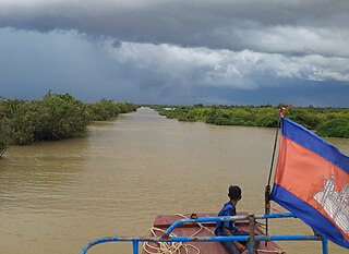
The Tonle Sap freshwater swamp forests ecoregion covers the seasonally flooded forests surrounding Tonlé Sap, the largest lake in Cambodia, and the floodplains of its connections to the Mekong River. Over 35% of the ecoregion experiences flooding during the wet season.

The Tonle Sap-Mekong peat swamp forests ecoregion covers a patchwork of areas permanently inundated with fresh water along the Tonle Sap River and Mekong River floodplains in Cambodia and Vietnam. The terrain is mostly flat, with extensive agricultural fields, reed beds, and degraded shrub forest. Less than 10% of the region is in its original state, and less than 1% is protected. Habitat in the region is distinguished from the Tonle Sap freshwater swamp forests ecoregion that runs through the middle, as that ecoregion is only seasonally flooded.

The Irrawaddy freshwater swamp forests ecoregion covers the freshwater portion of the delta of the Irrawaddy River, set back an average of 70 km from the Bay of Bengal by the saltwater mangroves. To the north is a rainforest belt with less inundated land. The region is extremely fertile due to the river-borne silt, but nearly-total conversion to agriculture has degraded the ecology. There are no fully protected areas in this ecoregion.
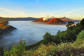
The Eastern Java–Bali montane rain forests ecoregion covers the higher altitude mountain rainforests on the eastern side of the island of Java, and most of the center of the island of Bali in Indonesia. The region has a number of active volcanoes, but is under pressure from growing human populations pushing into higher elevations and more marginal land. With elevations rising from sea level to 3,426 metres (11,240 ft), and precipitation varying between rainforest and drier forest levels, the area has many different forest types – evergreen, deciduous and semi-alpine.

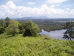
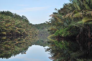
The Sumatran freshwater swamp forests ecoregion covers disconnected patches of freshwater swamp forest on the alluvial plains of the island of Sumatra in Indonesia. The different locations vary greatly in their vegetation and wildlife habitat depending on the local soil types. The land has been greatly disturbed by human conversion to agriculture and illegal logging in recent years. Several of the sectors support significant populations of Asian elephants (Elephas maximus)'.
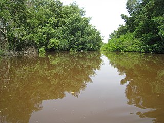
The Sumatran peat swamp forests ecoregion covers the low-lying peat swamp forests along the northeast coast of the island of Sumatra in Indonesia. As is typical for peat swamp forests, this ecoregion lies between a thin strip of saltwater-affected mangroves on the coast, and freshwater swamps and lowland rainforest forest on better drained soils further inland. Because the peat soil has relatively low nutrient levels, this ecoregion has been less used for agriculture, but burning and clearance has degraded half of the forest.

The Miskito pine forests ecoregion covers lowland pine forests and savanna along much of the Mosquito Coast in northeastern Nicaragua and southeastern Honduras. Pines are adapted to grow in the poor soil, relative to the surrounding moist forest, and repeated burning have left one species – the Caribbean pine – dominant. Although the ecoregion receives high levels of rain, the hard soils, repeated burning, and exposure to hurricanes have left expanses of 'pine savanna' and seasonal wetlands. The area is thinly settled by humans and there is little crop agriculture.
The Magdalena-Santa Marta mangroves ecoregion covers the mangrove forests along the coast of Colombia on the Caribbean Sea, from Gulf of Urabá in the west at the Colombia-Panama border to the Guajira Peninsula in the east. The region is relatively dry, with low precipitation and high evapotranspiration, so the mangroves depend for water and nutrients on the rivers flowing across the estuarine plain from the Sierra Nevada de Santa Marta mountains to the east. Efforts are currently underway to restore mangroves degraded by development and road building from the 1950s to 1980s.

The Moist Pacific Coast mangroves ecoregion covers a series of disconnected mangrove sites along the Pacific Ocean coast of Costa Rica and Panama. These sites occur mostly on coastal flatlands around lagoons, particularly where rivers from the inland mountains reach the sea, bringing fresh water to the coastal forests. The area is in a transition zone from the drier coastline to the north; rainfall in this ecoregions is over 2,000 mm/year, and reaches over 3,600 mm/year at the southern end.

The Petenes mangroves ecoregion covers mangrove habitat along the Gulf of Mexico coast of southern Mexico, where Campeche state and Yucatan state meet, centering on the Celestun Lagoon inland from the barrier-island town of Celestún. Because the region has relatively little rainfall and no rivers feeding the lagoons, the freshwater to support the mangrove ecosystem springs from underground aquifers. The area is important for migratory birds, and as a nesting area for sea turtles. The area around the Celestun Lagoon is protected by the Ría Celestún Biosphere Reserve, a UNESCO Biosphere Reserve, and Los Petenes Biosphere Reserve in Campeche.

The Ría Lagartos mangroves ecoregion covers mangrove habitats of along the northern coast of the Yucatan Peninsula, including the Ria Lagartos Lagoon. A prominent section of the ecoregion is covered by the Ría Lagartos Biosphere Reserve. The site is an important area for migratory birds, fish, and sea turtles.

The Rio Negro-Rio San Sun mangroves ecoregion covers a series of small of discontinuous mangrove forests on the Caribbean Sea coast of Costa Rica, from a small portion inside the border with Nicaragua in the west to the border with Panama in the east. The coast on this stretch is a flat, alluvial plain, and mangroves are only a small part of a diverse patchwork of local habitats including swamps, mixed rainforests, coastal lagoons, sea grass beds, and sandy beaches. Much of the territory is "blackwater river" in character - slow-moving channels in wooded swamps with water stained by decayed matter. These mangroves are periodically damaged by hurricanes, such as in 1988 from Hurricane Joan, but are able to regenerate.

The Trinidad mangroves ecoregion covers the separate mangrove forest areas on the coast of the island of Trinidad, in the country of Trinidad and Tobago. The character of the mangroves is affected by the large amount of fresh water flowing out of the Orinoco River and Amazon River to the south, which flow northwest around the island. The mangroves of Trinidad are found on all coasts, and are usually in the estuaries of rivers, but also found in coastal lagoons.

The Tehuantepec-El Manchon mangroves ecoregion covers a series of mangrove woodlands along the Pacific Ocean coast of the state of Chiapas, Mexico. The ecoregion is relatively large and continuous, with trees up to 25 meters in height. The region supports stands of a type of yellow mangrove that normally only grown further south. The coast of Mexico here is wet - over 2,500 mm/year of rain. Four RAMSAR wetlands of international important are found in the zone, and a UNESCO Biosphere Reserve. Of particular importance are the wide variety of permanent and migratory birds in the area.

The Trinidad and Tobago moist forests ecoregion covers most of Trinidad Island and Tobago Island near the coast of South America where the southeastern Caribbean Sea meets the Atlantic Ocean. Small portions of the islands around river estuaries and coastal lowlands are mangroves or dry forests. Species diversity is very high, in particular for plants and birds. Tobago, being much smaller, has fewer species.