
Brixton is an area of South London, part of the London Borough of Lambeth, England. The area is identified in the London Plan as one of 35 major centres in Greater London. Brixton experienced a rapid rise in population during the 19th century as communications with central London improved.

Lambeth is a London borough in South London, England, which forms part of Inner London. Its name was recorded in 1062 as Lambehitha and in 1255 as Lambeth. The geographical centre of London is at Frazier Street near Lambeth North tube station, though nearby Charing Cross on the other side of the Thames in the City of Westminster is traditionally considered the centre of London.
Lambeth was a civil parish and metropolitan borough in south London, England. It was an ancient parish in the county of Surrey. The parish was included in the area of responsibility of the Metropolitan Board of Works in 1855 and became part of the County of London in 1889. The parish of Lambeth became a metropolitan borough in 1900, following the London Government Act 1899, with the parish vestry replaced by a borough council.

Brockwell Park is a 50.8 hectare park located south of Brixton, in Herne Hill and Tulse Hill in south London. It is bordered by the roads Brixton Water Lane, Norwood Road, Tulse Hill and Dulwich Road.
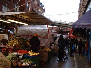
Brixton Market comprises a street market in the centre of Brixton, south London, and the adjacent covered market areas in nearby arcades Reliance Arcade, Market Row and Granville Arcade.

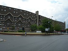
The Byker Wall is a long, unbroken block of 620 maisonettes in the Byker district of Newcastle upon Tyne, England. They were designed by Ralph Erskine and constructed in the 1970s. The wall is just part of the estate, which in total covers 200 acres.
Dulwich and West Norwood is a constituency in South London created in 1997. It has been represented by Helen Hayes of Labour since her election in 2015.
St Agnes Place was a squatted street in Kennington, south London, which resisted eviction orders for more than 30 years. When a number of derelict houses were scheduled for demolition to extend Kennington Park in 1969, squatters occupied the properties and a High Court injunction prevented the demolition. The street was run by a housing cooperative until 2005, when Lambeth London Borough Council obtained an eviction order. Demolition was completed in 2007.

Railton Road runs between Brixton and Herne Hill in the London Borough of Lambeth. The road is designated the B223. At the northern end of Railton Road it becomes Atlantic Road, linking to Brixton Road at a junction where the Brixton tube station is located. At the southern end is Herne Hill railway station.

Loughborough Junction is an area of South London, in the London Borough of Lambeth, which is located equidistant between Brixton, Camberwell and Herne Hill.
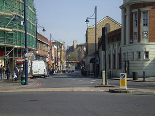
Coldharbour Lane is a road in south London, England, that leads south-westwards from Camberwell to Brixton. The road is over 1 mile (1.6 km) long with a mixture of residential, business and retail buildings – the stretch of Coldharbour Lane near Brixton Market contains shops, bars and restaurants. Between the junctions of Coldharbour Lane and Denmark Hill in Camberwell SE5 and Coldharbour Lane and Denmark Road lies part of the boundary between Lambeth and Southwark boroughs. The other end of Coldharbour Lane meets Acre Lane in central Brixton to form the A2217.

The Brixton murals are a series of murals by local artists in the Brixton area, in south London. Most of the murals were funded by Lambeth London Borough Council and the Greater London Council after the Brixton riots in 1981.
Coldharbour ward was an administrative division of the London Borough of Lambeth from 2002 to 2022. It is located in Brixton. The ward was replaced in 2022 by Brixton Acre Lane, Brixton Rush Common, Brixton Windrush, Herne Hill and Loughborough Junction, and Brixton North.

George Finch was a British architect. He was a committed socialist who believed architecture had the power to transform the lives of post-war Londoners. Finch's ideals drove his passion for designing social housing, civic and environmental buildings for everyday people built to the highest building standards.
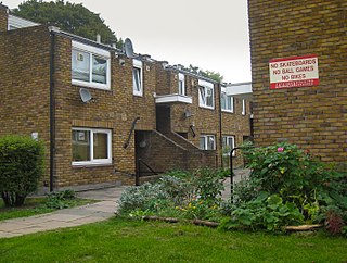
Cressingham Gardens is a council garden estate in Lambeth. It is located on the southern edge of Brockwell Park. It comprises 306 dwellings, a mixture of four, three and two-bedroom houses, and one-bedroom apartments. It was designed at the end of the 1960s by the Lambeth Borough Council Architect Edward Hollamby and second architect Roger Westman, and built at the start of the 1970s. In 2012 Lambeth Council proposed demolishing the estate, to replace the terraced houses by apartment blocks. Most of the apartments would then be for sale to the private sector. The residents, those in Lambeth who wish to prevent the gentrification of the borough, and those who want to conserve what they believe to be important architectural heritage, are campaigning to prevent its demolition.
Myatt's Fields South is a social housing estate located between Brixton Road and Camberwell New Road in South London. It is on land that once formed part of the Lambeth Wick estate.
Brixton House is an Off-West End theatre in Brixton in the London Borough of Lambeth, located at 385 Coldharbour Lane, London, SW9 8GL. It is the successor to Ovalhouse at Kennington, and opened in 2022.

Loughborough Road is in Brixton, in the south London Borough of Lambeth. Running between Brixton Road and Loughborough Junction, it has always been mainly residential, but in the past two centuries has included many shops and taverns.

Villa Road is a street in Angell Town in the Borough of Lambeth, south London. Rows of terraced houses, built on both sides of the street in the Victorian era, were scheduled to be demolished in the late 1960s as part of a development plan. From 1973 onwards, houses were squatted and an alternative community was established, containing anarchists, British Black Panthers, feminists, Marxists, primal screamers and single mothers. Lambeth Council applied for possession orders for most of the buildings on the street in June 1976 and the squatters built barricades to resist eviction. After prolonged negotiations the council decided to legalize the occupation in 1978, but only after demolishing the southern side of the street. In 2006, the former squatters were profiled in the documentary film "Property is Theft" as part of the BBC series Lefties.
