Spatial heterogeneity

Last updated
Land cover surrounding Madison, WI. Fields are colored yellow and brown, water is colored blue, and urban surfaces are colored red. NLCD landcover MSN area.png
Land cover surrounding Madison, WI. Fields are colored yellow and brown, water is colored blue, and urban surfaces are colored red.

Spatial heterogeneity is a property generally ascribed to a landscape or to a population. It refers to the uneven distribution of various concentrations of each species within an area. A landscape with spatial heterogeneity has a mix of concentrations of multiple species of plants or animals (biological), or of terrain formations (geological), or environmental characteristics (e.g. rainfall, temperature, wind) filling its area. A population showing spatial heterogeneity is one where various concentrations of individuals of this species are unevenly distributed across an area; nearly synonymous with "patchily distributed."

Contents

Terminology

Spatial heterogeneity can be re-phrased as scaling hierarchy of far more small things than large ones. It has been formulated as a scaling law. [1]

Spatial heterogeneity or scaling hierarchy can be measured or quantified by ht-index: a head/tail breaks induced number. [2] [3]

Examples

Environments with a wide variety of habitats such as different topographies, soil types, and climates are able to accommodate a greater amount of species. The leading scientific explanation for this is that when organisms can finely subdivide a landscape into unique suitable habitats, more species can coexist in a landscape without competition, a phenomenon termed "niche partitioning." Spatial heterogeneity is a concept parallel to ecosystem productivity, the species richness of animals is directly related to the species richness of plants in a certain habitat. Vegetation serves as food sources, habitats, and so on. Therefore, if vegetation is scarce, the animal populations will be as well. The more plant species there are in an ecosystem, the greater variety of microhabitats there are. Plant species richness directly reflects spatial heterogeneity in an ecosystem.

Types

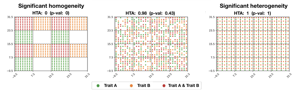
There exist two main types of spatial heterogeneity. The spatial local heterogeneity categorises the geographic phenomena whose its attributes' values are significantly similar within a directly local neighbourhood, but which significantly differ in the nearby surrounding-areas beyond this directly local neighbourhood (e.g. hot spots, cold spots). The spatial stratified heterogeneity categorises the geographic phenomena whose the within-strata variance of its attributes' values is significantly lower than its between-strata variance, such as collections of ecological zones or land-use classes within a given geographic area depict. [4]

Testing

Spatial local heterogeneity can be tested by LISA, Gi and SatScan, while spatial stratified heterogeneity of an attribute can be measured by geographical detector q-statistic: [4]

where a population is partitioned into h = 1, ..., L strata; N stands for the size of the population, σ2 stands for variance of the attribute. The value of q is within [0, 1], 0 indicates no spatial stratified heterogeneity, 1 indicates perfect spatial stratified heterogeneity. The value of q indicates the percent of the variance of an attribute explained by the stratification. The q follows a noncentral F probability density function.

A hand map with different spatial patterns. Note: p is the probability of q-statistic; * denotes statistical significant at level 0.05, ** for 0.001, *** for smaller than 10 ;(D) subscripts 1, 2, 3 of q and p denotes the strata Z1+Z2 with Z3,Z1 with Z2+Z3, and Z1 and Z2 and Z3 individually, respectively; (E) subscripts 1 and 2 of q and p denotes the strata Z1+Z2 with Z3+Z4,and Z1+Z3 with Z2+Z4, respectively. Q-fig2.jpg
A hand map with different spatial patterns. Note: p is the probability of q-statistic; * denotes statistical significant at level 0.05, ** for 0.001, *** for smaller than 10 ;(D) subscripts 1, 2, 3 of q and p denotes the strata Z1+Z2 with Z3,Z1 with Z2+Z3, and Z1 and Z2 and Z3 individually, respectively; (E) subscripts 1 and 2 of q and p denotes the strata Z1+Z2 with Z3+Z4,and Z1+Z3 with Z2+Z4, respectively.


Spatial heterogeneity for multivariate data and 3D data can also be statistically assessed using the "HTA index (HeTerogeneity Average index)".: [5]

HTA p-values for different distributions. Hta pvalues.jpg
HTA p-values for different distributions.

Models

Spatial stratified heterogeneity

Optimal parameters-based geographical detector

Optimal Parameters-based Geographical Detector (OPGD) characterizes spatial heterogeneity with the optimized parameters of spatial data discretization for identifying geographical factors and interactive impacts of factors, and estimating risks. [6] [7]

Interactive detector for spatial associations

Interactive Detector for Spatial Associations (IDSA) estimates power of interactive determinants (PID) on the basis of spatial stratified heterogeneity, spatial autocorrelation, and spatial fuzzy overlay of explanatory variables. [8]

Geographically optimal zones-based heterogeneity

Geographically Optimal Zones-based Heterogeneity (GOZH) explores individual and interactive determinants of geographical attributes (e.g., global soil moisture) across a large study area based on the identification of explainable geographically optimal zones. [9]

Robust geographical detector

Robust Geographical Detector (RGD) overcomes the limitation of the sensitivity in spatial data discretization and estimates robust power of determinants of explanatory variables. [10]

meta-STAR

The model-agnostic Spatial Transformation And modeRation (meta-STAR) is a framework for integrating the spatial heterogeneity into spatial statistical models (e.g. spatial ensemble methods, spatial neural networks), so to improve their accuracy. It involves the use of spatial networks/transformations and spatial moderators, plus handles the geo-spatial datasets representing geographic phenomena at multiple scales. [11]

Law of geography

In a 2004 publication titled "The Validity and Usefulness of Laws in Geographic Information Science and Geography," Michael Frank Goodchild proposed Spatial heterogeneity could be a candidate for a law of geography similar to Tobler's first law of geography. [12] The literature cites this paper and states this law as "geographic variables exhibit uncontrolled variance." [12] [13] [14] Often referred to as the second law of geography, or Michael Goodchild's second law of geography, it is one of many concepts competing for that term, including Tobler's second law of geography, and Arbia's law of geography. [13] [14] [15]

See also

Related Research Articles

<span class="mw-page-title-main">Landscape ecology</span> Science of relationships between ecological processes in the environment and particular ecosystems

Landscape ecology is the science of studying and improving relationships between ecological processes in the environment and particular ecosystems. This is done within a variety of landscape scales, development spatial patterns, and organizational levels of research and policy. Concisely, landscape ecology can be described as the science of "landscape diversity" as the synergetic result of biodiversity and geodiversity.

<span class="mw-page-title-main">Waldo R. Tobler</span> American geographer

Waldo Rudolph Tobler was an American-Swiss geographer and cartographer. Tobler is regarded as one of the most influential geographers and cartographers of the late 20th century and early 21st century. Tobler is most well known for his proposed idea that "Everything is related to everything else, but near things are more related than distant things," which has come to be referred to as the "first law of geography." He proposed a second law as well: "The phenomenon external to an area of interest affects what goes on inside."

<span class="mw-page-title-main">Optimal experimental design</span> Experimental design that is optimal with respect to some statistical criterion

In the design of experiments, optimal experimental designs are a class of experimental designs that are optimal with respect to some statistical criterion. The creation of this field of statistics has been credited to Danish statistician Kirstine Smith.

<span class="mw-page-title-main">Tobler's first law of geography</span> The first of several proposed laws of geography

The First Law of Geography, according to Waldo Tobler, is "everything is related to everything else, but near things are more related than distant things." This first law is the foundation of the fundamental concepts of spatial dependence and spatial autocorrelation and is utilized specifically for the inverse distance weighting method for spatial interpolation and to support the regionalized variable theory for kriging. The first law of geography is the fundamental assumption used in all spatial analysis.

<span class="mw-page-title-main">Health geography</span>

Health geography is the application of geographical information, perspectives, and methods to the study of health, disease, and health care. Medical geography, a sub-discipline of or sister field of health geography, focuses on understanding spatial patterns of health and disease as related to the natural and social environment. Conventionally, there are two primary areas of research within medical geography: the first deals with the spatial distribution and determinants of morbidity and mortality, while the second deals with health planning, help-seeking behavior, and the provision of health services.

<span class="mw-page-title-main">Spatial analysis</span> Formal techniques which study entities using their topological, geometric, or geographic properties

Spatial analysis is any of the formal techniques which studies entities using their topological, geometric, or geographic properties. Spatial analysis includes a variety of techniques using different analytic approaches, especially spatial statistics. It may be applied in fields as diverse as astronomy, with its studies of the placement of galaxies in the cosmos, or to chip fabrication engineering, with its use of "place and route" algorithms to build complex wiring structures. In a more restricted sense, spatial analysis is geospatial analysis, the technique applied to structures at the human scale, most notably in the analysis of geographic data. It may also be applied to genomics, as in transcriptomics data.

<span class="mw-page-title-main">Modifiable areal unit problem</span> Source of statistical bias

The modifiable areal unit problem (MAUP) is a source of statistical bias that can significantly impact the results of statistical hypothesis tests. MAUP affects results when point-based measures of spatial phenomena are aggregated into spatial partitions or areal units as in, for example, population density or illness rates. The resulting summary values are influenced by both the shape and scale of the aggregation unit.

Friction of distance is a core principle of geography that states that movement incurs some form of cost, in the form of physical effort, energy, time, and/or the expenditure of other resources, and that these costs are proportional to the distance traveled. This cost is thus a resistance against movement, analogous to the effect of friction against movement in classical mechanics. The subsequent preference for minimizing distance and its cost underlies a vast array of geographic patterns from economic agglomeration to wildlife migration, as well as many of the theories and techniques of spatial analysis, such as Tobler's first law of geography, network routing, and cost distance analysis. To a large degree, friction of distance is the primary reason why geography is relevant to many aspects of the world, although its importance has been decreasing with the development of transportation and communication technologies.

<span class="mw-page-title-main">Field (geography)</span> Property that varies over space

In the context of spatial analysis, geographic information systems, and geographic information science, a field is a property that fills space, and varies over space, such as temperature or density. This use of the term has been adopted from physics and mathematics, due to their similarity to physical fields (vector or scalar) such as the electromagnetic field or gravitational field. Synonymous terms include spatially dependent variable (geostatistics), statistical surface ( thematic mapping), and intensive property (physics and chemistry) and crossbreeding between these disciplines is common. The simplest formal model for a field is the function, which yields a single value given a point in space (i.e., t = f(x, y, z) )

<span class="mw-page-title-main">Geography</span> Study of lands and inhabitants of Earth

Geography is the study of the lands, features, inhabitants, and phenomena of Earth. Geography is an all-encompassing discipline that seeks an understanding of Earth and its human and natural complexities—not merely where objects are, but also how they have changed and come to be. While geography is specific to Earth, many concepts can be applied more broadly to other celestial bodies in the field of planetary science. Geography has been called "a bridge between natural science and social science disciplines."

A boundary problem in analysis is a phenomenon in which geographical patterns are differentiated by the shape and arrangement of boundaries that are drawn for administrative or measurement purposes. The boundary problem occurs because of the loss of neighbors in analyses that depend on the values of the neighbors. While geographic phenomena are measured and analyzed within a specific unit, identical spatial data can appear either dispersed or clustered depending on the boundary placed around the data. In analysis with point data, dispersion is evaluated as dependent of the boundary. In analysis with areal data, statistics should be interpreted based upon the boundary.

Quantitative geography is a subfield and methodological approach to geography that develops, tests, and uses scientific, mathematical, and statistical methods to analyze and model geographic phenomena and patterns. It aims to explain and predict the distribution and dynamics of human and physical geography through the collection and analysis of quantifiable data. The approach quantitative geographers take is generally in line with the scientific method, where a falsifiable hypothesis is generated, and then tested through observational studies. This has received criticism, and in recent years, quantitative geography has moved to include systematic model creation and understanding the limits of their models. This approach is used to study a wide range of topics, including population demographics, urbanization, environmental patterns, and the spatial distribution of economic activity. The methods of quantitative geography are often contrasted by those employed by qualitative geography, which is more focused on observing and recording characteristics of geographic place. However, there is increasing interest in using combinations of both qualitative and quantitative methods through mixed-methods research to better understand and contextualize geographic phenomena.

Taylor's power law is an empirical law in ecology that relates the variance of the number of individuals of a species per unit area of habitat to the corresponding mean by a power law relationship. It is named after the ecologist who first proposed it in 1961, Lionel Roy Taylor (1924–2007). Taylor's original name for this relationship was the law of the mean. The name Taylor's law was coined by Southwood in 1966.

<span class="mw-page-title-main">Head/tail breaks</span> Algorithm

Head/tail breaks is a clustering algorithm for data with a heavy-tailed distribution such as power laws and lognormal distributions. The heavy-tailed distribution can be simply referred to the scaling pattern of far more small things than large ones, or alternatively numerous smallest, a very few largest, and some in between the smallest and largest. The classification is done through dividing things into large and small things around the arithmetic mean or average, and then recursively going on for the division process for the large things or the head until the notion of far more small things than large ones is no longer valid, or with more or less similar things left only. Head/tail breaks is not just for classification, but also for visualization of big data by keeping the head, since the head is self-similar to the whole. Head/tail breaks can be applied not only to vector data such as points, lines and polygons, but also to raster data like digital elevation model (DEM).

<span class="mw-page-title-main">Tobler's second law of geography</span> One of several proposed laws of geography

The second law of geography, according to Waldo Tobler, is "the phenomenon external to a geographic area of interest affects what goes on inside." This is an extension of his first. He first published it in 1999 in reply to a paper titled "Linear pycnophylactic reallocation comment on a paper by D. Martin" and then again in response to criticism of his first law of geography titled "On the First Law of Geography: A Reply." Much of this criticism was centered on the question of if laws were meaningful in geography or any of the social sciences. In this document, Tobler proposed his second law while recognizing others have proposed other concepts to fill the role of 2nd law. Tobler asserted that this phenomenon is common enough to warrant the title of 2nd law of geography. Unlike Tobler's first law of geography, which is relatively well accepted among geographers, there are a few contenders for the title of the second law of geography. Tobler's second law of geography is less well known but still has profound implications for geography and spatial analysis.

<span class="mw-page-title-main">Arbia's law of geography</span> One of several proposed laws of geography

Arbia’s law of geography states, "Everything is related to everything else, but things observed at a coarse spatial resolution are more related than things observed at a finer resolution." Originally proposed as the 2nd law of geography, this is one of several laws competing for that title. Because of this, Arbia's law is sometimes referred to as the second law of geography, or Arbia's second law of geography.

Technical geography is the branch of geography that involves using, studying, and creating tools to obtain, analyze, interpret, understand, and communicate spatial information. The other branches, most commonly limited to human geography and physical geography, can usually apply the concepts and techniques of technical geography. However, the methods and theory are distinct, and a technical geographer may be more concerned with the technological and theoretical concepts than the nature of the data. Further, a technical geographer may explore the relationship between the spatial technology and the end users to improve upon the technology and better understand the impact of the technology on human behavior. Thus, the spatial data types a technical geographer employs may vary widely, including human and physical geography topics, with the common thread being the techniques and philosophies employed. To accomplish this, technical geographers often create their own software or scripts, which can then be applied more broadly by others. They may also explore applying techniques developed for one application to another unrelated topic, such as applying Kriging, originally developed for mining, to disciplines as diverse as real-estate prices. In teaching technical geography, instructors often need to fall back on examples from human and physical geography to explain the theoretical concepts. While technical geography mostly works with quantitative data, the techniques and technology can be applied to qualitative geography, differentiating it from quantitative geography. Within the branch of technical geography are the major and overlapping subbranches of geographic information science, geomatics, and geoinformatics.


The neighborhood effect averaging problem or NEAP delves into the challenges associated with understanding the influence of aggregating neighborhood-level phenomena on individuals when mobility-dependent exposures influence the phenomena. The problem confounds the neighbourhood effect, which suggests that a person's neighborhood impacts their individual characteristics, such as health. It relates to the boundary problem, in that delineated neighborhoods used for analysis may not fully account for an individuals activity space if the borders are permeable, and individual mobility crosses the boundaries. The term was first coined by Mei-Po Kwan in the peer-reviewed journal "International Journal of Environmental Research and Public Health" in 2018.

Alexander Stewart Fotheringham is a British-American geographer known for his contributions to quantitative geography and geographic information science (GIScience). He holds a Ph.D. in geography from McMaster University and is a Regents professor of computational spatial science in the School of Geographical Sciences and Urban Planning at Arizona State University. He has contributed to the literature surrounding spatial analysis and spatial statistics, particularly in the development of geographically weighted regression (GWR) and multiscale geographically weighted regression (MGWR).

References

  1. Jiang B. 2015. Geospatial analysis requires a different way of thinking: The problem of spatial heterogeneity. GeoJournal 80(1), 113.
  2. Jiang B. and Yin J. 2014. Ht-index for quantifying the fractal or scaling structure of geographic features, Annals of the Association of American Geographers, 104(3), 530541.
  3. Jiang B. 2013. Head/tail breaks: A new classification scheme for data with a heavy-tailed distribution, The Professional Geographer, 65 (3), 482494.
  4. 1 2 Wang JF, Zhang TL, Fu BJ. 2016. A measure of spatial stratified heterogeneity. Ecological Indicators 67: 250-256.
  5. 1 2 Alona Levy-Jurgenson and others, Assessing heterogeneity in spatial data using the HTA index with applications to spatial transcriptomics and imaging, Bioinformatics, Volume 37, Issue 21, November 2021, Pages 3796–3804, https://doi.org/10.1093/bioinformatics/btab569
  6. Song, Yongze; Wang, Jinfeng; Ge, Yong; Xu, Chengdong (2020). "An optimal parameters-based geographical detector model enhances geographic characteristics of explanatory variables for spatial heterogeneity analysis: cases with different types of spatial data". GIScience & Remote Sensing. 57 (5): 593–610. doi:10.1080/15481603.2020.1760434. hdl: 20.500.11937/79549 . ISSN   1548-1603. S2CID   219418482.
  7. Song, Yongze (2021). "Optimal Parameters-based Geographical Detectors (OPGD) Model for Spatial Heterogeneity Analysis and Factor Exploration".
  8. Song, Yongze; Wu, Peng (2021). "An interactive detector for spatial associations". International Journal of Geographical Information Science. 35 (8): 1676–1701. doi:10.1080/13658816.2021.1882680. ISSN   1365-8816. S2CID   234812819.
  9. Luo, Peng; Song, Yongze; Huang, Xin; Ma, Hongliang; Liu, Jin; Yao, Yao; Meng, Liqiu (2022). "Identifying determinants of spatio-temporal disparities in soil moisture of the Northern Hemisphere using a geographically optimal zones-based heterogeneity model". ISPRS Journal of Photogrammetry and Remote Sensing. 185: 111–128. Bibcode:2022JPRS..185..111L. doi:10.1016/j.isprsjprs.2022.01.009. S2CID   246496936.
  10. Zhang, Zehua; Song, Yongze; Wu, Peng (2022). "Robust geographical detector". International Journal of Applied Earth Observation and Geoinformation. 109: 102782. doi: 10.1016/j.jag.2022.102782 . hdl: 20.500.11937/88650 . S2CID   248470509.
  11. Xie Y, Chen W, He E, Jia X, Bao H, Zhou X, Ghosh R, Ravirathinam P (2023). "Harnessing heterogeneity in space with statistically guided meta-learning". Knowledge and Information Systems. 65 (6): 2699–2729. doi: 10.1007/s10115-023-01847-0 . PMC   9994417 . PMID   37035130.
  12. 1 2 Goodchild, Michael (2004). "The Validity and Usefulness of Laws in Geographic Information Science and Geography". Annals of the Association of American Geographers. 94 (2): 300–303. doi:10.1111/j.1467-8306.2004.09402008.x. S2CID   17912938.
  13. 1 2 Zou, Muquan; Wang, Lizhen; Wu, Ping; Tran, Vanha (23 July 2022). "Mining Type-β Co-Location Patterns on Closeness Centrality in Spatial Data Sets". ISPRS Int. J. Geo-Inf. 11 (8): 418. doi: 10.3390/ijgi11080418 .
  14. 1 2 Zhang, Yu; Sheng, Wu; Zhao, Zhiyuan; Yang, Xiping; Fang, Zhixiang (30 January 2023). "An urban crowd flow model integrating geographic characteristics". Scientific Reports. 13. doi: 10.1038/s41598-023-29000-5 . PMC   9886992 .
  15. Tobler, Waldo (2004). "On the First Law of Geography: A Reply". Annals of the Association of American Geographers. 94 (2): 304–310. doi:10.1111/j.1467-8306.2004.09402009.x. S2CID   33201684 . Retrieved 10 March 2022.