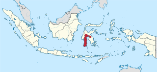
South Sulawesi is a province in the southern peninsula of Sulawesi, Indonesia. The Selayar Islands archipelago to the south of Sulawesi is also part of the province. The capital and largest city is Makassar. The province is bordered by Central Sulawesi and West Sulawesi to the north, the Gulf of Bone and Southeast Sulawesi to the east, Makassar Strait to the west, and Flores Sea to the south.

West Nusa Tenggara is a province of Indonesia. It comprises the western portion of the Lesser Sunda Islands, with the exception of Bali which is its own province. The province's land area is 19,931.45 km2. The two largest islands by far in the province are the smaller but much more populated Lombok in the west and the much larger in area but much less densely populated Sumbawa island in the east. Mataram, on Lombok, is the capital and largest city of the province. It shares maritime borders with Bali to the west and East Nusa Tenggara to the east.

Anambas Islands Regency is a small archipelago of Indonesia, located 150 nautical miles northeast of Batam Island in the North Natuna Sea between the Malaysian mainland to the west and the island of Borneo to the east. Geographically part of the Tudjuh Archipelago, it is administratively a regency within the Riau Islands Province. It covers a land area of 590.14 square kilometres (227.85 sq mi) and had a population of 37,411 at the 2010 Census and 47,402 at the 2020 Census; the official estimate as at mid 2022 was 50,296. The administrative centre is at Tarempa on Siantan Island.

The Obi Islands are a group of 42 islands in the Indonesian province of North Maluku, north of Buru and Ceram, and south of Halmahera. With a total area of 3,048.08 km2, they had a population of 41,455 at the 2010 Census and 50,760 at the 2020 Census. The official estimate as at mid 2022 was 52,588.

Peleng is an island off the east coast of Sulawesi, Indonesia and is the largest island of the Banggai Islands. It is surrounded by the Banda Sea and Molucca Sea and has an area of 2,488.79 km2.
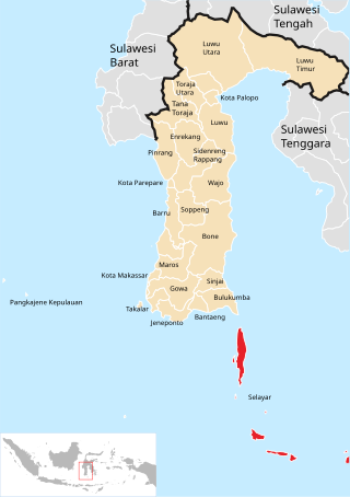
The Selayar Islands Regency is a regency of Indonesia in South Sulawesi province that covers the Selayar Islands, which lie southeast of the southern peninsula of Sulawesi. The archipelago consists of the group's main island, which is surrounded by 41 smaller islands around its coast; further to the southeast lies a widespread group of islands, including the huge atoll of Takabonerate. The regency covers an area of 1,357.03 km2, and had a population of 103,596 at the 2000 Census, 122,055 at the Census of 2010 and 137,071 at that of 2020. The official estimate for mid 2022 was 139,145. The administrative centre is the town of Benteng on Selayar Island. The Selayar Straits separate the regency from Sulawesi island.

Soppeng Regency is a landlocked regency in South Sulawesi province of Indonesia. Soppeng Regency has its seat of government (capital) in the town of Watansoppeng, located 180 km from Makassar. The regency covers an area of 1,557 km2, and had a population of 223,826 at the 2010 Census and 235,167 at the 2020 Census. The official estimate of population as of mid-2022 was 236,049.

Polewali Mandar is one of the five regencies in West Sulawesi province of Indonesia. It borders on the regencies of Mamasa in the North, Majene in the West and Pinrang regency of South Sulawesi in the East. It covers an area of 2,074.76 km2 and had a population of 396,120 at the 2010 Census and 478,534 at the 2020 Census; the official estimate as at mid 2022 was 490,493. The regency is inhabited by various ethnic groups such as the Mandar, Buginese, Javanese and Toraja.
Masamba is a small river town and district (kecamatan) in the North Luwu Regency of South Sulawesi Province of Indonesia which serves as the seat of the regency. The town lies on the Patikala River. It is served by Andi Jemma Airport. The district covers an area of 1,068.85 km2 and had a population of 38,024 at the 2020 Census; the official estimate as at mid 2022 was 39,152 . Much of the land in the region is swampy coastal plains with mangroves found in its shallow waters.

Meranti Islands is an archipelago forming a regency (kabupaten) of Riau Province and lies off the eastern coast of the island of Sumatra, Indonesia. It was created on 19 December 2008 by the separating of this archipelago from the mainland regency of Bengkalis. The regency comprises the islands of Tebing Tinggi, Rangsang, Padang, and Merbau, together with minor offshore islands, but does not include Bengkalis Island which is geographically part of the archipelago but remains within Bengkalis Regency. The principal town is Selat Panjang on Tebing Tinggi Island. The regency covers an area of 3,623.93 km2 and had a population of 176,290 at the 2010 Census and 206,116 at the 2020 Census; the official estimate as of mid-2022 was 213,532.

Maros Regency is a regency of South Sulawesi province of Indonesia. It covers an area of 1,619.12 sq.km, and had a population of 319,002 at the 2010 Census and 391,774 at the Census of 2020. The official population estimate for mid-2022 was 403,774. Almost all of the regency lies within the official metropolitan area of the city of Makassar. The capital town of the regency is Maros.

The Pangkajene and Islands Regency, is a regency of South Sulawesi province of Indonesia. The regency lies primarily on the mainland of Sulawesi's southern peninsula, but also includes the Spermonde Islands off the west coast of that peninsula, as well as other small islands further west and southwest. The principal town lies at Pangkajene on Sulawesi, but there are a series of further small towns like Lejang, Labakkang, Bonto-Bonto and Segeri proceeding northwards from Pangkajene along the Trans-Sulawesi Highway. The total land area is 1,112.29 km2, and the population was 305,737 at the 2010 Census and 345,775 at the 2020 Census; the official population estimate as of mid-2022 was 351,426.

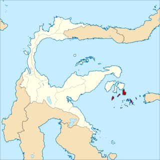
Sinjai Regency is a regency of the South Sulawesi province of Indonesia. The regency, which is separated from the Bone Regency to its north by the River Tangka, covers an area of 819.96 km2. It had a population of 228,936 at the 2010 census and 259,478 at the 2020 census. The official estimate of population as of mid-2022 was 263,827. It includes the Nine Islands in the Gulf of Bone off the east coast of the southern peninsula of Sulawesi; this archipelago forms a district within the regency. The regency's principal town lies at Sinjai, a port situated on the east coast of that peninsula.

Takalar Regency is a regency of South Sulawesi Province, Indonesia. It covers an area of 566.51 km2 and had a population of 269,603 at the 2010 census and 300,853 at the 2020 census; the official estimate for mid 2022 was 305,077. The entire regency lies within the official metropolitan area of the city of Makassar. The principal towns are at Galesong and Takalar, but the administrative centre is at Pattallassang.

The Banggai Archipelago is a group of islands, which are located at the far eastern end of Central Sulawesi, Indonesia. It makes up a regency (kabupaten) of Central Sulawesi Province of Indonesia, created on 4 October 1999 by splitting the existing Banggai Regency into a new Banggai Regency situated on the mainland of Sulawesi and a Banggai Islands Regency then comprising the entire archipelago. On 14 December 2012 a further splitting of the Regency was the removal of the more southerly seven districts to form a new Banggai Laut Regency.

Poso Regency is a regency of Central Sulawesi Province of Indonesia. It covers an area of 7,112.25 km2, and had a population of 209,228 at the 2010 Census and 244,875 at the 2020 Census; the official estimate as at mid 2022 was 252,650. The principal town lies at Poso.

Tojo Una-Una Regency is a regency of Central Sulawesi, Indonesia. The administrative centre is at Ampana town, on the Sulawesi 'mainland'. While the Regency includes a considerable area on the eastern peninsula of Sulawesi, it also includes the Togian Islands in the Gulf of Tomini. The total area covers 5,721.51 km2 and the population was 134,945 at the 2010 Census and 163,829 at the 2020 Census; the official estimate as at mid 2022 was 169,478.

The Sangihe Islands Regency is a regency of North Sulawesi Province, Indonesia. It comprises a group of islands situated to the North of Sulawesi. It covers a land area of 736.98 km2, and had a population of 126,100 at the 2010 census and 139,262 at the 2020 census; the official estimate as at mid 2022 was 140,165. The principal island is also named Sangihe, on which lies the main town of Tahuna. Minor island groups within the Regency include the Marore group considerably to the north of Sangihe Island, the Tatoareng group to the south, and the Nusa Tabukan group off the northeast coast of Sangihe Island. It borders the Philippines in the north, making it one of Indonesia's border regions.

North Toraja is a landlocked regency (kabupaten) of South Sulawesi Province of Indonesia, and the home of the Toraja ethnic group. The local government seat is in Rantepao which is also the center of Toraja culture. Formerly this regency was the northern part of Tana Toraja Regency, but on 24 June 2008 the northeastern 36% of the latter's area was split off to form this separate North Toraja Regency. It covers an area of 1,151.47 km2 and had a population of 216,762 at the 2010 census and 261,086 at the 2020 census; the official estimate as at mid 2022 was 268,198, comprising 136,998 males and 131,200 females.
Banggai Laut Regency is a regency in the province of Central Sulawesi, Indonesia. The regency was established on 14 December 2012, partitioned from the Banggai Islands Regency. It comprises southern part of the Banggai Islands archipelago, including the main island of Banggai itself, the islands of Labobo and Bangkurung to the southwest of Banggai Island, and the numerous small Bokan Islands to the southeast. It covers a land area of 725.67 km2, and the districts now comprising the new Regency had a population of 62,183 at the 2010 Census and 70,435 at the 2020 Census; the official estimate as at mid 2022 was 71,350.

