Sportsmen Acres, Oklahoma

Last updated

Sportsmen Acres, Oklahoma
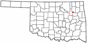
OKMap-doton-SportsmenAcres.PNG
Location of Sportsmen Acres, Oklahoma
Coordinates: 36°14′45″N95°15′05″W / 36.24583°N 95.25139°W / 36.24583; -95.25139
Country United States
State Oklahoma
County Mayes
Area
[1]
  Total0.08 sq mi (0.22 km2)
  Land0.08 sq mi (0.22 km2)
  Water0.00 sq mi (0.00 km2)
Elevation
[2]
614 ft (187 m)
Population
 (2020)
  Total317
  Density3,819.28/sq mi (1,468.56/km2)
Time zone UTC-6 (Central (CST))
  Summer (DST) UTC-5 (CDT)
FIPS code 40-69400 [3]
GNIS feature ID2413317 [2]

Sportsmen Acres is a town in Mayes County, Oklahoma, United States. The population was 322 at the 2010 census. Incorporated in 1972, Sportsmen Acres is primarily a residential community. [4] It is located seven miles southeast of Pryor on Oklahoma State Highway 69A, and one mile east of the MidAmerica Industrial Park. [4]

Contents

Geography

According to the United States Census Bureau, the town has a total area of 0.1 square miles (0.26 km2), all land.

Demographics

Historical population
CensusPop.Note
1980 218
1990 181−17.0%
2000 20412.7%
2010 32257.8%
2020 317−1.6%
U.S. Decennial Census [5]

As of 2010 Sportsmen Acres had a population of 322. The racial and ethnic composition of the population was 70.5% white, 20.2% Native American, 0.3% Filipino, 1.2% from some other race and 7.8% from two or more races. 2.8% of the population was Hispanic or Latino of any race. [6]

As of the census [3] of 2000, there were 204 people, 58 households, and 52 families residing in the town. The population density was 2,456.8 inhabitants per square mile (948.6/km2). There were 63 housing units at an average density of 758.7 per square mile (292.9/km2). The racial makeup of the town was 85.29% White, 6.37% Native American, 4.90% Asian, and 3.43% from two or more races. Hispanic or Latino of any race were 0.49% of the population.

There were 58 households, out of which 55.2% had children under the age of 18 living with them, 81.0% were married couples living together, 6.9% had a female householder with no husband present, and 10.3% were non-families. 8.6% of all households were made up of individuals, and 3.4% had someone living alone who was 65 years of age or older. The average household size was 3.52 and the average family size was 3.73.

In the town, the population was spread out, with 36.3% under the age of 18, 12.3% from 18 to 24, 25.5% from 25 to 44, 21.6% from 45 to 64, and 4.4% who were 65 years of age or older. The median age was 26 years. For every 100 females, there were 85.5 males. For every 100 females age 18 and over, there were 88.4 males.

The median income for a household in the town was $37,222, and the median income for a family was $38,333. Males had a median income of $30,909 versus $21,000 for females. The per capita income for the town was $14,233. About 3.6% of families and 4.6% of the population were below the poverty line, including 7.1% of those under the age of eighteen and none of those 65 or over.

Related Research Articles

<span class="mw-page-title-main">Derby Acres, California</span> Census-designated place in California, United States

Derby Acres is a census-designated place (CDP) in Kern County, California, United States. Derby Acres is located 5.5 miles (8.9 km) north-northwest of Fellows, at an elevation of 1,375 feet (419 m). The population was 322 at the 2010 census, down from 376 at the 2000 census. The town is on State Route 33 at the northern extremity of the Midway-Sunset Oil Field, about five miles (8 km)five miles southeast of McKittrick.

Hermon is a town in Penobscot County, Maine, United States. The population was 6,461 at the 2020 census.

<span class="mw-page-title-main">Canton, Oklahoma</span> Town in Oklahoma, United States

Canton is a town in Blaine County, Oklahoma, United States. The population was 625 at the 2010 census.
<span class="mw-page-title-main">Hinton, Oklahoma</span> Town in Oklahoma, United States

Hinton is a town in Caddo County, Oklahoma, United States. The population was 3,196 as of the 2010 census, up from 2,175 in 2000. It is approximately 50 miles (80 km) west of Oklahoma City.
<span class="mw-page-title-main">Etowah, Oklahoma</span> Town in Oklahoma, United States

Etowah is a town in Cleveland County, Oklahoma, United States. The population was 159 at the 2020 census, a 72.8% increase from 2010.

<span class="mw-page-title-main">Indiahoma, Oklahoma</span> Town in Oklahoma, United States

Indiahoma is a town in Comanche County, Oklahoma, United States. It is located just south of US Route 62, about 24.4 driving miles west of Lawton.

<span class="mw-page-title-main">Amber, Oklahoma</span> Town in Oklahoma, United States

Amber is a town in Grady County, Oklahoma, United States. The population was 413 at the 2020 census, a 1.4% decrease from 2010.

<span class="mw-page-title-main">Bradley, Oklahoma</span> Town in Oklahoma, United States

Bradley is a town in Grady County, Oklahoma, United States. The population was 78 at the 2020 United States census.

<span class="mw-page-title-main">Ninnekah, Oklahoma</span> Town in Oklahoma, United States

Ninnekah is a town in Grady County, Oklahoma, United States. The population was 775 at the 2020 census, a 22.7% decrease from 2010.

<span class="mw-page-title-main">Granite, Oklahoma</span> Town in Oklahoma, United States

Granite is a town in Greer County, Oklahoma, United States. The population was 1,628 at the 2020 census.

<span class="mw-page-title-main">Davenport, Oklahoma</span> Town in Oklahoma, United States

Davenport is a town in Lincoln County, Oklahoma, United States. The population was 814 at the 2010 census.

<span class="mw-page-title-main">Kendrick, Oklahoma</span> Town in Oklahoma, United States

Kendrick is a town in Lincoln County, Oklahoma, United States. The population was 139 at the 2010 census.

<span class="mw-page-title-main">Cole, Oklahoma</span> Town in Oklahoma, United States

Cole is a town in McClain County, Oklahoma, United States. The population was 624 at the 2020 census, up from 555 at the 2010 census.

<span class="mw-page-title-main">Millerton, Oklahoma</span> Town in Oklahoma, United States

Millerton is a town in McCurtain County, Oklahoma, United States. The population was 359 at the 2000 census. The oldest church building in Oklahoma, Wheelock Church, is located near Millerton.

<span class="mw-page-title-main">Lake Aluma, Oklahoma</span> Town in Oklahoma, United States

Lake Aluma is a town in Oklahoma County, Oklahoma, United States, and a part of the Oklahoma City Metropolitan Area. The population was 88 at the 2010 census.

<span class="mw-page-title-main">Bethel Acres, Oklahoma</span> Town in Oklahoma, United States

Bethel Acres is a town in Pottawatomie County, Oklahoma, United States. The population was 2,895 at the time of the 2010 census, an increase of 5.9 percent from the figure of 2,735 in 2000. It is primarily a bedroom community for people who work in the three nearby larger cities of Shawnee, Tecumseh and Oklahoma City.
<span class="mw-page-title-main">Johnson, Oklahoma</span> Town in Oklahoma, United States

Johnson is a town in north-central Pottawatomie County, Oklahoma, United States. The population was 247 at the 2010 census, a 10.8 percent increase from the figure of 223 in 2000.

<span class="mw-page-title-main">Tribbey, Oklahoma</span> Town in Oklahoma, United States

Tribbey is a town in Pottawatomie County, Oklahoma, United States.The community was named for Alpheus M. Tribbey, landowner. The population was 337 by the 2020 United States census.

<span class="mw-page-title-main">Bray, Oklahoma</span> Town in Oklahoma, United States

Bray is a town in Stephens County, Oklahoma, United States. The population was 1,209 at the 2010 census.
<span class="mw-page-title-main">Fair Oaks, Oklahoma</span> Town in Oklahoma, United States

Fair Oaks is a town in Rogers and Wagoner counties in the U.S. state of Oklahoma. The population was 103 at the 2010 census, a 15.6 percent decline from the figure of 122 recorded in 2000. It is a suburb of Tulsa.

References

  1. "ArcGIS REST Services Directory". United States Census Bureau. Retrieved September 20, 2022.
  2. 1 2 U.S. Geological Survey Geographic Names Information System: Sportsmen Acres, Oklahoma
  3. 1 2 "U.S. Census website". United States Census Bureau . Retrieved January 31, 2008.
  4. 1 2 "Sportsmen Acres". Betty Lou Harper Thomas, Oklahoma Historical Society. Retrieved March 27, 2020.
  5. "Census of Population and Housing". Census.gov. Retrieved June 4, 2015.
  6. 2010 general profile of population and housing characteristics of Sportsmen Acres from the US census