Spring City, Tennessee | |
---|---|
Town of Spring City | |
Coordinates: 35°41′22″N84°51′50″W / 35.68944°N 84.86389°W | |
Country | United States |
State | Tennessee |
County | Rhea |
Area | |
• Total | 2.80 sq mi (7.25 km2) |
• Land | 2.76 sq mi (7.16 km2) |
• Water | 0.04 sq mi (0.09 km2) |
Elevation | 768 ft (234 m) |
Population | |
• Total | 1,949 |
• Density | 705.14/sq mi (272.27/km2) |
Time zone | UTC-5 (Eastern (EST)) |
• Summer (DST) | UTC-4 (EDT) |
ZIP codes | 37337, 37381 |
Area code | 423 |
FIPS code | 47-70400 [4] |
GNIS feature ID | 1303755 [2] |
Website | www |
Spring City is a town in Rhea County, Tennessee, United States. The population was 1,949 at the 2020 census and 1,981 at the 2010 census. The town is located along Watts Bar Lake, and Watts Bar Dam and the Watts Bar Nuclear Generating Station are nearby.
Spring City began as a stop along the Cincinnati Southern Railroad in the 1870s. The town was originally named Sulphur Springs, because of the mass amount of sulphur in the water. Sometime later it became "Rheaville," and later became incorporated with nearby Rhea Springs, and took on the name Rhea Springs. Due to an explosion, much of the town flooded or burnt, and the town relocated to its current location and was renamed Spring City, in honor of the original settlement, Sulphur Springs. The original location now lies at the bottom of a nearby section of Watts Bar Lake. Spring City thrived as a railroad shipping hub during the late 19th and early 20th centuries. Its first railroad depot, a simple wooden building constructed in 1879, burned in 1892, and was replaced by a larger one. [5] This second depot was in turn replaced by the current depot, which was completed by the Southern Railway in 1909. [6]
The city received an economic boost in 1942 with the Tennessee Valley Authority's completion of Watts Bar Dam and its associated reservoir southeast of the town. That same year saw the completion of the Watts Bar Fossil Plant, TVA's first coal-fired plant. In 1973, TVA began building Watts Bar Nuclear Plant. Its first reactor, Watts Bar Unit 1, became active in 1996. The construction of the second reactor, Watts Bar Unit 2, was originally suspended in 1985, but resumed in 2007. It entered commercial operation in October 2016.
On August 22, 1955, 11 schoolchildren were killed, and many others injured, when their school bus was struck by a 103-car freight train at a track crossing in Spring City. [7]
On July 28, 2016, a train hauling coal derailed by the train depot and museum due to a faulty wheel on one of the privately owned coal cars. There were no casualties. A lengthy cleanup followed, where both track crossings in town had to be closed while repairs were made and debris cleared.
Spring City is located at 35°41′22″N84°51′50″W / 35.68944°N 84.86389°W (35.689422, -84.863885). [8]
According to the United States Census Bureau, the town has a total area of 2.5 square miles (6.5 km2), of which, 2.4 square miles (6.2 km2) of it is land and 0.04 square miles (0.10 km2) of it (1.21%) is water.
Climate data for Spring City, Tennessee, 1991–2020 normals, extremes 2003–present | |||||||||||||
---|---|---|---|---|---|---|---|---|---|---|---|---|---|
Month | Jan | Feb | Mar | Apr | May | Jun | Jul | Aug | Sep | Oct | Nov | Dec | Year |
Record high °F (°C) | 75 (24) | 81 (27) | 85 (29) | 88 (31) | 92 (33) | 103 (39) | 104 (40) | 103 (39) | 96 (36) | 96 (36) | 85 (29) | 76 (24) | 104 (40) |
Mean maximum °F (°C) | 65.7 (18.7) | 71.1 (21.7) | 79.5 (26.4) | 84.5 (29.2) | 87.3 (30.7) | 92.5 (33.6) | 94.1 (34.5) | 94.0 (34.4) | 90.5 (32.5) | 84.3 (29.1) | 73.4 (23.0) | 67.9 (19.9) | 95.8 (35.4) |
Mean daily maximum °F (°C) | 47.5 (8.6) | 51.7 (10.9) | 60.4 (15.8) | 70.6 (21.4) | 77.2 (25.1) | 83.9 (28.8) | 86.9 (30.5) | 86.7 (30.4) | 81.0 (27.2) | 70.8 (21.6) | 58.8 (14.9) | 50.3 (10.2) | 68.8 (20.5) |
Daily mean °F (°C) | 36.9 (2.7) | 40.5 (4.7) | 47.8 (8.8) | 57.0 (13.9) | 65.3 (18.5) | 73.0 (22.8) | 76.7 (24.8) | 75.9 (24.4) | 69.7 (20.9) | 58.2 (14.6) | 46.8 (8.2) | 39.9 (4.4) | 57.3 (14.1) |
Mean daily minimum °F (°C) | 26.2 (−3.2) | 29.2 (−1.6) | 35.2 (1.8) | 43.5 (6.4) | 53.5 (11.9) | 62.2 (16.8) | 66.5 (19.2) | 65.2 (18.4) | 58.4 (14.7) | 45.5 (7.5) | 34.8 (1.6) | 29.5 (−1.4) | 45.8 (7.7) |
Mean minimum °F (°C) | 9.9 (−12.3) | 14.9 (−9.5) | 20.0 (−6.7) | 29.2 (−1.6) | 37.1 (2.8) | 53.0 (11.7) | 58.2 (14.6) | 57.3 (14.1) | 46.5 (8.1) | 31.0 (−0.6) | 21.3 (−5.9) | 16.8 (−8.4) | 8.1 (−13.3) |
Record low °F (°C) | −5 (−21) | 0 (−18) | 15 (−9) | 20 (−7) | 24 (−4) | 47 (8) | 51 (11) | 47 (8) | 40 (4) | 25 (−4) | 12 (−11) | 3 (−16) | −5 (−21) |
Average precipitation inches (mm) | 5.71 (145) | 5.24 (133) | 5.46 (139) | 5.60 (142) | 4.13 (105) | 5.06 (129) | 5.61 (142) | 3.07 (78) | 4.77 (121) | 3.63 (92) | 5.11 (130) | 6.01 (153) | 59.40 (1,509) |
Average snowfall inches (cm) | 0.4 (1.0) | 0.7 (1.8) | 0.1 (0.25) | 0.0 (0.0) | 0.0 (0.0) | 0.0 (0.0) | 0.0 (0.0) | 0.0 (0.0) | 0.0 (0.0) | 0.0 (0.0) | 0.0 (0.0) | 0.1 (0.25) | 1.3 (3.3) |
Average precipitation days (≥ 0.01 in) | 11.5 | 12.6 | 10.6 | 10.1 | 11.4 | 11.3 | 13.1 | 9.6 | 7.9 | 8.2 | 8.9 | 11.9 | 127.1 |
Average snowy days (≥ 0.1 in) | 0.5 | 0.5 | 0.1 | 0.0 | 0.0 | 0.0 | 0.0 | 0.0 | 0.0 | 0.0 | 0.0 | 0.2 | 1.3 |
Source 1: NOAA [9] | |||||||||||||
Source 2: National Weather Service (mean maxima/minima 2006–2020) [10] |
Census | Pop. | Note | %± |
---|---|---|---|
1890 | 598 | — | |
1900 | 640 | 7.0% | |
1910 | 1,039 | 62.3% | |
1920 | 1,001 | −3.7% | |
1930 | 1,090 | 8.9% | |
1940 | 1,569 | 43.9% | |
1950 | 1,725 | 9.9% | |
1960 | 1,800 | 4.3% | |
1970 | 1,756 | −2.4% | |
1980 | 1,951 | 11.1% | |
1990 | 2,199 | 12.7% | |
2000 | 2,025 | −7.9% | |
2010 | 1,981 | −2.2% | |
2020 | 1,949 | −1.6% | |
Sources: [11] [12] [3] |
Race | Number | Percentage |
---|---|---|
White (non-Hispanic) | 1,745 | 89.53% |
Black or African American (non-Hispanic) | 53 | 2.72% |
Native American | 5 | 0.26% |
Asian | 13 | 0.67% |
Other/Mixed | 80 | 4.1% |
Hispanic or Latino | 53 | 2.72% |
As of the 2020 United States census, there were 1,949 people, 935 households, and 537 families residing in the town.
As of the census [4] of 2000, there were 2,025 people, 861 households, and 533 families residing in the town. The population density was 829.9 inhabitants per square mile (320.4/km2). There were 974 housing units at an average density of 399.2 per square mile (154.1/km2). The racial makeup of the town was 94.52% White, 4.49% African American, 0.40% Native American, 0.05% Asian, and 0.54% from two or more races. Hispanic or Latino of any race were 0.49% of the population.
There were 861 households, out of which 24.7% had children under the age of 18 living with them, 44.9% were married couples living together, 12.7% had a female householder with no husband present, and 38.0% were non-families. 33.8% of all households were made up of individuals, and 17.8% had someone living alone who was 65 years of age or older. The average household size was 2.21 and the average family size was 2.83.
In the town, the population was spread out, with 20.4% under the age of 18, 7.4% from 18 to 24, 23.9% from 25 to 44, 23.5% from 45 to 64, and 24.9% who were 65 years of age or older. The median age was 44 years. For every 100 females, there were 86.0 males. For every 100 females age 18 and over, there were 81.1 males.
The median income for a household in the town was $27,009, and the median income for a family was $31,894. Males had a median income of $27,692 versus $22,050 for females. The per capita income for the town was $14,506. About 15.5% of families and 21.0% of the population were below the poverty line, including 32.7% of those under age 18 and 18.8% of those age 65 or over.
Rhea County Schools is the local school district. [14] The elementary and middle schools are Spring City Elementary School and Spring City Middle School. [15] [16] The district's sole high school is Rhea County High School.
Washington County is a county located in the U.S. state of Tennessee. As of the 2020 census, the population was 133,001. Its county seat is Jonesborough. The county's largest city and a regional educational, medical and commercial center is Johnson City. Washington County is Tennessee's oldest county, having been established in 1777 when the state was still part of North Carolina. Washington County is part of the Johnson City, TN Metropolitan Statistical Area, which is a component of the Johnson City–Kingsport–Bristol, TN-VA Combined Statistical Area, commonly known as the "Tri-Cities" region.
Roane County is a county of the U.S. state of Tennessee. As of the 2020 census, the population was 53,404. Its county seat is Kingston. Roane County is included in the Knoxville, TN Metropolitan Statistical Area.
Rhea County is a county located in the U.S. state of Tennessee. As of the 2020 census, its population was 32,870. Its county seat is Dayton. Rhea County comprises the Dayton, TN micropolitan statistical area, which is also included in the Chattanooga-Cleveland-Dalton, TN-GA-AL combined statistical area.
Meigs County is a county located in the U.S. state of Tennessee. As of the 2020 census, the population was 12,758. Its county seat is Decatur.
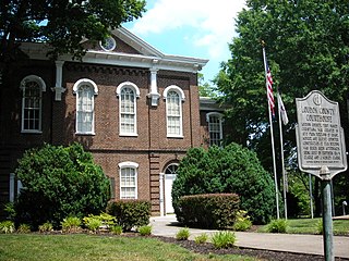
Loudon County is a county in the U.S. state of Tennessee. It is located in the central part of East Tennessee. As of the 2020 census, the population was 54,886. Its county seat is Loudon. Loudon County is included in the Knoxville, TN Metropolitan Statistical Area.
Cumberland County is a county located in the U.S. state of Tennessee. As of the 2020 census, the population was 61,145. Its county seat is Crossville. Cumberland County comprises the Crossville, TN micropolitan statistical area.
White Sulphur Springs is a city in and the county seat of Meagher County, Montana, United States. The population was 955 at the 2020 census.
Parsons is a city in Decatur County, Tennessee, United States. The population was 2,373 at the 2010 census. Parsons is the largest city by population in Decatur County.
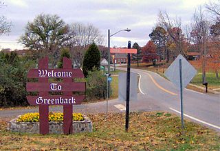
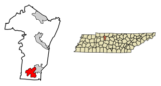
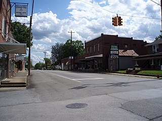
Greenback is a city in Loudon County, Tennessee, United States. Its population was at 1,102, according to the 2020 census. It is included in the Knoxville Metropolitan Statistical Area.
Chapel Hill is a town in northeastern Marshall County, Tennessee, United States. The town was named after Chapel Hill, North Carolina, by settlers from that area. The population was 1,717 as of the 2020 census.
Dayton is a city in and the county seat of Rhea County, Tennessee, United States. As of the 2020 census, the city population was 7,065. The Dayton Urban Cluster, which includes developed areas adjacent to the city and extends south to Graysville.
Graysville is a town in Rhea County, Tennessee, United States. The population was 1,471 at the 2020 census and 1,502 at the 2010 census.
Kingston is a city in and the county seat of Roane County, Tennessee, United States. This city is thirty-six miles southwest of Knoxville. It had a population of 5,934 at the 2010 United States census, and is included in the Harriman, Tennessee Micropolitan Statistical Area. Kingston is adjacent to Watts Bar Lake.
Bartlett is a city in Shelby County, Tennessee, United States. The population was 57,786 at the 2020 U.S. Census.
Portland is a city in Sumner and Robertson counties in Tennessee. The population was 11,486 in 2010 according estimates by the U.S. census bureau and in 2020 the population was 13,156. Portland is a part of the Nashville Metropolitan Statistical Area.
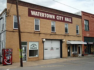
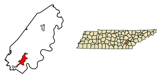
Watertown is a town located in Wilson County, Tennessee. The population was 1,477 at the 2010 census. The population then raised to 1,556 after the 2020 census. It is located southeast of Lebanon, and northwest of Smithville.
McKenzie is a city at the tripoint of Carroll, Henry, and Weakley counties in Tennessee, United States. The population was 5,310 at the 2010 census.
Tennessee Ridge is a town in Houston and Stewart counties in the U.S. state of Tennessee. The population was 1,332 at the 2020 census and 1,368 at the 2010 census.
Spring Hill is a city in Maury and Williamson counties in the U.S. state of Tennessee, located approximately 30 miles (48 km) south of Nashville. Its population as of 2022 is 55,800. Spring Hill is recognized as the 4th fastest growing city in Tennessee by the U.S. Census Bureau and is included in the Nashville metropolitan area.
Sweetwater is a city in Monroe and McMinn counties in the U.S. state of Tennessee, and the most populous city in Monroe County. As of the 2020 census, its population was 6,312. Sweetwater is the home of the Craighead Caverns which contains the Lost Sea, the United States' largest underground lake. In 2022, TravelMag named Sweetwater one of Tennessee’s Ten Most Charming Cities.
270 East Jackson Avenue Spring City, TN 37381
751 Wassom Memorial Highway, Spring City, TN 37381