The Fairlie–Poplar Historic District is part of the central business district in downtown Atlanta. It is named for the two streets that cross at its center, northeast-only Fairlie and southeast-only Poplar. Fairlie–Poplar is immediately north of Five Points, the definitive centerpoint and longtime commercial heart of Atlanta. It is roughly bounded on the southwest by Marietta Street, on the southeast by Peachtree Street or Park Place, on the northeast by Luckie Street or Williams Street, and on the northwest by Cone Street or Spring Street. It has smaller city blocks than the rest of the city, and the streets run at a 40° diagonal.

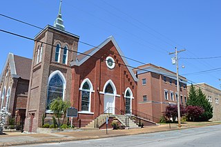
Springville Center for the Arts is a non-profit community multi-arts center located at Springville in Erie County, New York. It is housed in the historic The Baptist Church of Springville, a historic Baptist church. It was built in 1869, and is a red brick Late Gothic Revival-style church with limestone trim. It features a square corner bell tower.

Wakefield Park Historic District is a residential historic district encompassing a portion of a late-19th/early-20th century planned development in western Wakefield, Massachusetts. The district encompasses sixteen properties on 8 acres (3.2 ha) of land out of the approximately 100 acres (40 ha) that comprised the original development. Most of the properties in the district are on Park Avenue, with a few located on immediately adjacent streets.

The Canton Center Historic District encompasses the historic rural town center of Canton, Connecticut. Extending mainly along Connecticut Route 179, near the geographic town center, is a well-preserved example of rural agricultural center in Connecticut, a role served until about 1920. The district includes many examples of Late Victorian and Greek Revival architecture. It was listed on the National Register of Historic Places in 1997.
The Adams Street Historic District in Franklin, Tennessee consists of properties at 1112-1400 Adams, 1251-1327 Adams St., and 304-308 Stewart St. It is a 14-acre (5.7 ha) historic district was listed on the National Register of Historic Places in 2000 and is one of seven local historic districts in the city of Franklin.

The Lowndesboro Historic District is a historic district in Lowndesboro, Alabama, United States. It was placed on the National Register of Historic Places on December 12, 1973. The district covers 1,800 acres (730 ha), spread over the entire town, and contains 20 contributing properties, including Meadowlawn Plantation. Architectural styles include the Gothic Revival, Greek Revival, and other Victorian styles.
The Charles E. Loose House is a historic house located in Provo, Utah, United States. The house was individually nominated for listing on the National Register of Historic Places in 1982 but was not listed due to owner objection. It later was included as a contributing property in the Provo East Central Historic District.

The John R. Twelves House is a historic house located in Provo, Utah, United States. It is listed on the National Register of Historic Places.

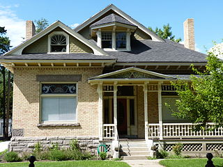
The Mont and Harriet Johnson House, at 153 E 400 N in Springville, Utah, United States, is a Late Victorian-style house built in 1901. It was listed on the National Register of Historic Places in 1998. The listing included three contributing buildings.

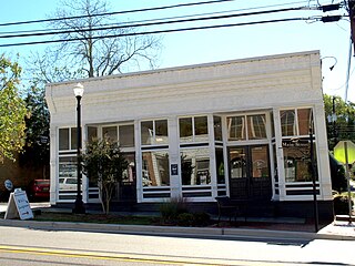
The Sheffield Downtown Commercial Historic District is a historic district in downtown Sheffield, Alabama. The buildings in the district were mostly built from 1888 to 1959 and have served a variety of purposes. Significant commercial buildings in the district include the Sheffield Hardware Company building, the Blake Building, and the Montgomery Block. Many of the city's important government buildings, including the Fire Department-City Hall building, Chamber of Commerce, and post office, are also part of the district. Various architectural styles can be seen in the district, including Renaissance Revival, High Victorian Gothic, and Moderne. The district was added to the National Register of Historic Places on May 24, 2010.

The Madison Station Historic District is a historic district in Madison, Alabama. Madison was first settled around 1818 as a farming community, but significant growth began in 1858, when the first depot was built along the Memphis and Charleston Railroad line. Madison Station became an important loading point for the shipment of cotton, supplanting the Tennessee River as the preferred means of shipment. Merchants and other businesses soon followed, with many people moving from the river port of Triana. After a lull during the Civil War, the town's growth continued; Madison was incorporated in 1869. The town grew steadily until the 1950s, when industry spurred by the expansion of Redstone Arsenal replaced cotton as the primary economic force in Madison County.

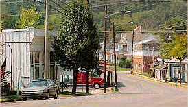
The Downtown Guntersville Historic District is a historic district in Guntersville, Alabama. The district includes most of the central business district of Guntersville, as well as some houses. The town was founded in the 1820s as a port on the Tennessee River. Most of the town was destroyed during the Civil War, although the Henry-Jordan House was spared. The business district began to rebuild after the war, and development was spurred in the late 19th and early 20th century by the Nashville, Chattanooga, and St. Louis Railway and by manufacturing firms. The opening of Guntersville Dam by the Tennessee Valley Authority in 1939 turned Guntersville into a peninsula, and created tourism and recreation opportunities on the new lake. Many commercial buildings were constructed after World War II until 1964, in contrast to many small-town downtown areas. Popular architectural styles from the time are represented, including elaborately decorated Victorian, simpler commercial brick styles, and post-war streamlined styles. Notable contributing properties in the district are the Albert G. Henry, Jr., House, the Henry-Jordan House, and the Guntersville Post Office, all of which are individually listed on the National Register of Historic Places. The district was listed on the National Register in 2012.

The Collinsville Historic District is a historic district in Collinsville, Alabama. After the Cherokee were removed in 1835, Collinsville was founded on land owned by Alfred Collins, a settler from Rhea County, Tennessee. By 1848, he held title to over 680 acres. In 1852, construction began on the Wills Valley Railroad, running through Collinsville between Chattanooga, and Elyton ; the company was renamed to the Alabama Great Southern Railroad in 1877. The town began to grow, and was incorporated in 1887. Two fires in 1884 and 1900 destroyed most of the commercial buildings, and floods also plagued the town; a levee on Little Wills Creek was constructed in 1937 by the Works Progress Administration. The historic district is primarily residential with the remainder commercial, as well as two churches, a garage, two industrial buildings, three bridges, and the levee. Commercial buildings are mostly built in simple, commercial styles, and nearly all date from after the 1900 fire. Notable is the Art Moderne Cricket Theatre, built in 1946. The majority of houses date from 1891 through 1930, many of which are Queen Anne and Late Victorian, American Craftsman, and Vernacular styles. The district was listed on the National Register of Historic Places in 2006.

The Public Square Historic District is a historic district in Scottsboro, Alabama. Although Scottsboro had been the county seat of Jackson County since 1870, the town's earliest commercial development was centered on the Memphis and Charleston Railroad line, one block north of the square. After an 1881 fire along the rail line, some businesses began to rebuild around the square. Once the Tennessee Valley Authority brought prosperity to the region in the 1930s, development around the courthouse began to accelerate. The current Jackson County Courthouse was built in 1912 with matching Classical Revival porticos on two sides. Commercial buildings around the square are one or two stories and all of brick. While most are built in simple, lightly decorated commercial styles, some late 19th-century buildings have Victorian detailing. The district was listed on the Alabama Register of Landmarks and Heritage in 1981 and the National Register of Historic Places in 1982.

The Bank Street–Old Decatur Historic District is a historic district in Decatur, Alabama. The district encompasses the original commercial and residential portion of Decatur along the Tennessee River. In 1832, Decatur was selected over the larger Huntsville as the site of the northern branch of the state bank. Bank Street became the commercial hub of the town, as it was the only place in the Tennessee Valley were riverboat, wagon, and rail transportation converged. Due to its strategic location, the town suffered heavy damage in the Civil War; the Todd House on Lafayette Street is one of only four buildings in Decatur to survive the war. As the town was rebuilding from the war, a fire in 1877 destroyed most of the buildings along Bank Street. The rebuilt structures were all of brick, and represent Italianate, Victorian, and Commercial styles popular from the late 19th to the early 20th centuries. Houses in the district are primarily modest, and styles include vernacular Victorian, Shingle-style, and Craftsman bungalows.

The New Decatur–Albany Historic District is a historic district in Decatur, Alabama. The district encompasses the commercial district of the former town of New Decatur. It lies south of the Bank Street-Old Decatur Historic District and east of the New Decatur–Albany Residential Historic District. New Decatur was founded in 1887 as a planned town and suburb of Decatur. The town was renamed Albany in 1916 and merged with "Old" Decatur in 1927.
The Tuscumbia Historic District is a historic district in Tuscumbia, Alabama. The district contains 461 contributing properties and covers about 232 acres of the town's original area. The first white settlers in Tuscumbia built a village next to Big Spring, at the site of what is today Spring Park. Many settlers, many from Virginia and Maryland, began to emigrate to The Shoals in the 1820s and 1830s. The oldest houses in the district are Tidewater-type cottages, a style native to the Middle Atlantic. Also built during the town's early period are some of the oldest commercial buildings in Alabama, including the Morgan-Donilan Building and a seven-building block known as Commercial Row. The town's economy declined in the 1840s, when many farmers left seeking more fertile soil, through the Civil War and Reconstruction.

The Roanoke Downtown Historic District is a historic district in Roanoke, Alabama. Roanoke was settled in the 1830s, but became a major agricultural trading center in East Alabama following the Civil War. The Central of Georgia Railway extended its line to the town in 1887, soon followed by the Atlanta, Birmingham and Atlantic Railway, and a large cotton warehouse was founded the same year. The commercial district began growing from this time, mostly with one-story brick structures, some of which carry influences from Romanesque Revival, Italianate, and Beaux-Arts details. The W. A. Handley Company built a textile mill in Roanoke in 1901, which would remain the major employer in the town until its closing in the early 1980s.

The Kimballton Commercial District is a nationally recognized historic district located in Kimballton, Iowa, United States. It was listed on the National Register of Historic Places in 1995. At the time of its nomination the district consisted of 34 resources, including 26 contributing buildings and 8 non-contributing buildings. The district covers parts of four blocks of the central business district. The commercial buildings are mostly masonry structures constructed with locally produced bricks and concrete blocks. Eleven of the buildings are frame construction. The buildings are from one to two stories in height, and Late Victorian architectural styles dominate. Because of the hilly terrain, buildings on one side of Main Street have exposed basements, while those on the other side of street are built into the side of a hill. The Bennedsen, Boldt, and Hansen Building is individually listed on the National Register.

The Palisado Avenue Historic District encompasses a predominantly residential streetscape in northeastern Windsor, Connecticut. Extending along Palisado Avenue between the Farmington River and Bissell Ferry Road, it is a basically 18th-century street view, populated mainly with houses from the 18th to the 20th centuries. The district was listed on the National Register of Historic Places in 1987.