
Laurence Harbor is an unincorporated community and census-designated place (CDP) located on the Raritan Bay within Old Bridge Township, in Middlesex County, in the U.S. state of New Jersey. As of the 2020 United States census, the CDP's population was 6,635, an increase of 99 (+1.5%) from the 6,536 recorded at the 2010 census, which in turn reflected an increase of 309 (+5.0%) from the 6,227 counted in the 2000 census.

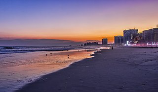
The Jersey Shore is the coastal region of the U.S. state of New Jersey. Geographically, the term encompasses about 141 miles (227 km) of oceanfront bordering the Atlantic Ocean, from Perth Amboy in the north to Cape May Point in the south. The region includes Middlesex, Monmouth, Ocean, Atlantic, and Cape May counties, which are in the central and southern parts of the state. Located in the center of the Northeast Megalopolis, the northern half of the shore region is part of the New York metropolitan area, while the southern half of the shore region is part of the Philadelphia metropolitan area, also known as the Delaware Valley. The Jersey Shore hosts the highest concentration of oceanside boardwalks in the United States.
South Jersey comprises the southern portion of the U.S. state of New Jersey located between Pennsylvania and the lower Delaware River in the west and the Atlantic Ocean in the east. The designation of South Jersey with a distinct toponym is a colloquialism rather than an administrative definition and reflects geographical and perceived cultural and other differences between South Jersey and the northern part of the state. South Jersey is part of the Philadelphia metropolitan area, the seventh-largest metropolitan region in the nation with 6.288 million residents in the core metropolitan statistical area and 7.366 million residents in the combined statistical area as of 2020. South Jersey is known for containing the unique ecoregion known as the Pine Barrens, which remains largely undisturbed despite its location within the Northeastern megalopolis. The South Jersey Pine Barrens are the largest remaining example of the Atlantic coastal pine barrens ecosystem.

The Port of Philadelphia is located on the Delaware River in Philadelphia in the U.S. state of Pennsylvania.

The Rose Fitzgerald Kennedy Greenway is a linear park located in several Downtown Boston neighborhoods. It consists of landscaped gardens, promenades, plazas, fountains, art, and specialty lighting systems that stretch over one mile through Chinatown, the Financial District, the Waterfront, and North End neighborhoods. Officially opened in October 2008, the 17-acre Greenway sits on land created from demolition of the John F. Fitzgerald Expressway as part of the Big Dig project.

Governor Tom McCall Waterfront Park is a 36.59-acre (148,100 m2) park located in downtown Portland, Oregon, along the Willamette River. After the 1974 removal of Harbor Drive, a major milestone in the freeway removal movement, the park was opened to the public in 1978. The park covers 13 tax lots and is owned by the City of Portland. The park was renamed in 1984 to honor Tom McCall, the Oregon governor who pledged his support for the beautification of the west bank of the Willamette River—harkening back to the City Beautiful plans at the turn of the century which envisioned parks and greenways along the river. The park is bordered by RiverPlace to the south, the Steel Bridge to the north, Naito Parkway to the west, and Willamette River to the east. In October 2012, Waterfront Park was voted one of America's ten greatest public spaces by the American Planning Association.

Penn's Landing is a waterfront area of Center City Philadelphia, Pennsylvania, United States, situated along the Delaware River. Its name commemorates the landing of William Penn, the founder of Pennsylvania, in 1682. The actual landing site is farther south, in Chester. The city of Philadelphia purchased the right to use the name. Penn's Landing is bounded by Front Street to the west, the Delaware River to the east, Spring Garden Street to the north, and Washington Avenue to the south, and is primarily focused on the Christopher Columbus Boulevard corridor.

The Swann Memorial Fountain is an art deco fountain sculpture located in the center of Logan Circle in Philadelphia, Pennsylvania, United States.
The Freedom Mortgage Pavilion is an outdoor amphitheatre and indoor theater complex in Camden, New Jersey located in the Camden Waterfront entertainment district on the Delaware River across from Philadelphia.

Southwest Philadelphia is a section of Philadelphia, Pennsylvania, United States. The section can be described as extending from the western side of the Schuylkill River to the city line, with the SEPTA. The northern border is defined by the Philadelphia City Planning Commission as east from the city line along Baltimore Avenue moving south along 51st Street to Springfield Ave. It follows the train tracks until 49th Street. From 49th and Kingsessing Ave the line moves east along Kingsessing Ave. The line then moves south along 46th St to Paschall Ave where it jogs to join Grays Ferry where the line runs to the Schuylkill River.

The Slate Roof House was a mansion that stood on 2nd Street north of Walnut Street in Philadelphia, Pennsylvania, from about 1687 until its demolition in 1867. Built for Barbadian Quaker merchant Samuel Carpenter, the house occupied a small hill overlooking the Delaware River. It was built of brick]in the Jacobean style with its façade featuring two projecting wings that flanked a recessed central entrance. The house was notable for its large size as well for its slate roof, which was a rarity in early Philadelphia.
Front Street in Philadelphia, Pennsylvania is a north–south street running parallel to and near the Delaware River. In 1682, when the city was laid out by William Penn, it was the first street surveyed and built in during the colonial era Province of Pennsylvania. As part of the King's Highway, which extended from Boston to Charleston, South Carolina, and as the waterfront of Philadelphia's port, it was the most important street in the city from its founding into the 19th century.
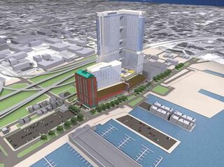
Renaissance Plaza is a proposed residential and retail complex to be built on a 5.5-acre (2.2 ha) site in the Delaware Riverfront region of Philadelphia, Pennsylvania. The previous World Trade Square complex design was to be developed by Carl Marks Real Estate Group and called for four high-rise office buildings: Old City Harbor Tower I, Old City Harbor Tower II, Old City Harbor Tower III, and the Greater Philadelphia World Trade Center.

Charles Center is a large-scale urban redevelopment project in central Baltimore's downtown business district of the late 1950s and early 1960s. Beginning in 1954, a group called the "Committee for Downtown" promoted a master plan for arresting the commercial decline of central Baltimore. In 1955, the "Greater Baltimore Committee", headed by banker and developer James W. Rouse, joined the effort. A plan was developed by noted American urban planner and architect David A. Wallace, (1917−2004), strongly supported by Mayors Thomas L. J. D'Alesandro, Jr. (1947−1959) and Theodore R. McKeldin, and many in their administrations, which formed the basis of a $25 million bond issue voted on by the citizens of Baltimore City during the municipal elections in November 1958. The architects' view of the overall Charles Center Redevelopment Plan with the conceptions of possible buildings, lay-out and plan that was publicized to the voters that spring and summer before, only slightly resembles the actual buildings and designs that later were really constructed by the mid-1970s.
The Camden Children's Garden is operated by the Camden City Garden Club, Inc and is located on the Camden Waterfront, across from downtown Philadelphia. This venue was created in 1999 and is designed for children and families. This 4.5-acre (1.8 ha) garden features a variety of themed educational exhibits for children for creative and imaginative play, such as the Dinosaur Garden, a Giant Picnic Garden, Storybook Gardens, Red Oak Run and Tree House, Cityscapes Garden and more! The facility includes indoor attractions such as the Philadelphia Eagles Four Seasons Butterfly House, Plaza de Aibonito, a Puerto Rican tropical greenhouse exhibit, and Benjamin Franklin’s Secret Garden and Workshop. Many exhibits and gardens were original displays in the Philadelphia Flower Show and come back to the Camden Children's Garden to find a permanent home. There are three amusement rides: Carousel, Arrow River Express Train Ride, and Spring Butterfly Ride. The Garden is closed January and February. Garden Festivals are family-oriented special events held at the Garden on the second and fourth weekends of the month, from April through November. The Garden also hosts the Annual Holiday Festival of Lights through December.
Callowhill Depot is a bus and trolley barn operated by the Southeastern Pennsylvania Transportation Authority (SEPTA), located in West Philadelphia, near the Delaware County border. It was built in 1913 by the Philadelphia Rapid Transit Company (PRT) and was later operated by the Philadelphia Transportation Company (PTC) before being taken over by SEPTA. The depot was constructed as part of the Thomas E. Mitten modernization program. Since its construction, the depot has suffered fire damage and reconstruction in 1949, 1950, and 1995.

The Camden Waterfront, also known as the Central Waterfront, is a commercial and entertainment district in Camden, New Jersey, on the Delaware River south of the Ben Franklin Bridge and north of Port of Camden.

Dock Creek was a stream draining much of what is now the eastern half of Center City, Philadelphia. It was a tributary of the Delaware River. By 1820, the entire creek had been covered and converted to a sewer. The present-day Dock Street follows the lower course of the stream.

The Washington Avenue Immigration Station was an immigrant processing facility in Philadelphia, Pennsylvania, United States located at the end of Washington Avenue at Pier 53 on the Delaware River, south of modern-day Penn's Landing waterfront district. The building opened in 1873 and was demolished in 1915.

