Related Research Articles

Corfe Castle is a village and civil parish in the English county of Dorset. It is the site of a ruined castle of the same name. The village and castle stand over a gap in the Purbeck Hills on the route between Wareham and Swanage. The village lies in the gap below the castle and is around four miles (6.4 km) south-east of Wareham, and four miles (6.4 km) north-northwest of Swanage. Both the main A351 road from Lytchett Minster to Swanage and the Swanage Railway thread their way through the gap and the village.

Swanage is a coastal town and civil parish in the south east of Dorset, England. It is at the eastern end of the Isle of Purbeck and one of its two towns, approximately 6+1⁄4 miles (10 km) south of Poole and 25 miles (40 km) east of Dorchester. In the 2011 census the civil parish had a population of 9,601. Nearby are Ballard Down and Old Harry Rocks, with Studland Bay and Poole Harbour to the north. Within the parish are Durlston Bay and Durlston Country Park to the south of the town. The parish also includes the areas of Herston, just to the west of the town, and Durlston, just to the south.

Langton Matravers is a village and civil parish on the Isle of Purbeck, in the county of Dorset in the south of England. It is situated about 2 miles (3.2 km) west of Swanage town centre and 5 miles (8 km) south-east of Corfe Castle. In the 2011 Census the civil parish had 381 households and a population of 853.

Lytchett Matravers is a large village and civil parish in Dorset, England. The 2011 census recorded the parish as having 1,439 households and a population of 3,424.

Worth Matravers is a village and civil parish in the English county of Dorset. The village is situated on the cliffs west of Swanage. It comprises limestone cottages and farm houses and is built around a pond, which is a regular feature on postcards of the Isle of Purbeck.

Sydling St Nicholas is a village and civil parish in Dorset within southwest England. The parish is 5 to 9 miles northwest of the county town Dorchester and covers most of the valley of the small Sydling Water in the chalk hills of the Dorset Downs. The parish has an area of 2,075 hectares and includes the hamlet of Up Sydling in the north.

Wootton Fitzpaine is a village and civil parish in the county of Dorset in South West England. It lies approximately 3 miles (4.8 km) north-east of Lyme Regis in a small side valley of the River Char, close to the Marshwood Vale. The civil parish covers an area of 3,307 acres (1,338 ha) and includes the ecclesiastical parish and small settlement of Monkton Wyld to the west. In the 2011 census the civil parish had 180 dwellings, 134 households and a population of 345.
River Cottage is a brand used for a number of ventures by television chef Hugh Fearnley-Whittingstall. These include a long-running Channel 4 television series, cookery courses, events, restaurants and products such as beer and organic yogurts.
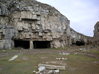
Winspit is a disused quarry on the cliffs near Worth Matravers in the Isle of Purbeck, Dorset, England. To the west and east are the hills of West Man and East Man.
Newton Surmaville is a 15,129-square-foot (1,405.5 m2) stately home with gardens and a park south of Yeovil, Somerset in the district of South Somerset, in England. It lies just outside the town in the parish of Barwick.

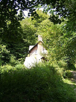
Thomas Hardy's Cottage, in Higher Bockhampton, Dorset, is a small cob and thatch building that is the birthplace of the English author Thomas Hardy. He was born there in 1840 and lived in the cottage until he was aged 34—during which time he wrote the novels Under the Greenwood Tree (1872) and Far from the Madding Crowd (1874)—when he left home to be married to Emma Gifford.

Poxwell is a hamlet and civil parish in the county of Dorset in southwest England. It is located 6 miles (9.7 km) east of Weymouth. The current population of the parish is around 50.
Durnford School was an English preparatory school for boys which opened in 1894 on the Isle of Purbeck in Dorset.
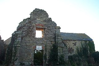
Kilve Chantry was a religious site in Kilve, Somerset, England.
St Mary the Virgin is the Church of England parish church of Lytchett Matravers in Dorset. Its parish is part of the Diocese of Salisbury. The building is Grade I listed.

St Alban's Head is a headland located 5 kilometres (3.1 mi) southwest of Swanage, on the coast of Dorset, England. It is the most southerly part of the Purbeck peninsula, and comprises an outcrop of Portland Stone from the overlying Lower Purbeck Stone. It is part of the Jurassic Coast, a World Heritage Site. It is designated a Special Area of Conservation under the European Union's Habitats Directive.

The Square and Compass is a Grade II listed public house in Worth Matravers, Dorset. Built in the 18th century as a pair of cottages before becoming a public house, the Square and Compass got its name in 1830 from a landlord who had been a stonemason. The building includes a museum of fossils and other local artefacts and the pub is one of only five nationally that has been included in every edition of CAMRA's Good Beer Guide since 1974.


The Priest's Way is the historical route taken by clergy from St Nicholas's, Worth Matravers to St Mary's Church, Swanage in the Isle of Purbeck in Dorset. The track arose as a result of St Mary's being a chapel of ease to St Nicholas's, and followed the route priests took to say mass in Swanage. A modern footpath and bridleway follows much of the route.
References
- ↑ "UK Fossils: Keates Quarry". 3 March 2017. Retrieved 11 September 2021.
- 1 2 3 "Dorset Area of Outstanding Natural Beauty: Spyway" . Retrieved 11 September 2021.
- ↑ "Historic England List Entry 1323406" . Retrieved 11 September 2021.
- 1 2 "National Trust: Scratch Arse Ware and Dancing Ledge Walk" . Retrieved 11 September 2021.
- ↑ "Langton Matravers Parish Council: Priest's Way" . Retrieved 11 September 2021.
- ↑ "National Trust Holidays: Spyway" . Retrieved 11 September 2021.