
Palakkad is one of the 14 districts in the Indian state of Kerala. It was carved out of the southeastern region of the former Malabar District on 1 January 1957. It is located at the central region of Kerala and is the second largest district in the state after Idukki. The city of Palakkad is the district headquarters. Palakkad is bordered on the northwest by the Malappuram district, on the southwest by the Thrissur district, on the northeast by Nilgiris district, and on the east by Coimbatore district of Tamil Nadu. The district is nicknamed "The granary of Kerala". Palakkad is the gateway to Kerala due to the presence of the Palakkad Gap, in the Western Ghats. The 2,383 m high Anginda peak, which is situated in the border of Palakkad district, Nilgiris district, and Malappuram district, in Silent Valley National Park, is the highest point of elevation in Palakkad district. Palakkad city is about 347 kilometres (216 mi) northeast of the state capital, Thiruvananthapuram.

Brahmapur is a city on the eastern coastline of Odisha, India.

Alipurduar is a city and a municipality in the Indian state of West Bengal. It is the headquarters of the Alipurduar district. Situated on the east bank of Kaljani River in the foothills of the Himalayas, the city is a gateway to Bhutan and the northeastern states of India. Alipurduar was a sub-divisional town of Jalpaiguri district until 2014 when it was created a separate district.
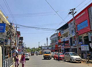
Alathur is a town, taluk and gram panchayat in Palakkad District, Kerala, India. It is the administrative headquarters of the Alathur Taluk and is situated about 24 km from the district headquarters Palakkad through National Highway 544.Gayathripuzha River ,one of the tributary of Bharathapuzha, flows through Alathur. Alathur is one among the 29 Parliamentary Constituencies in Kerala. A Mini Civil Station is also located here which provides government related services.

Attappadi (HQ:Agali) is a tribal taluk in Kerala state covering an area of 735 km2 (284 sq mi). It is carved out from Mannarkkad taluk in Palakkad district in February 2021. Attappadi Reserve Forest is a protected area comprising 249 km2 of land area in the western parts of Attappadi. It is one among the reserved forests and protected forests of India. Attappadi valley in Palakkad district along with the neighbouring Chaliyar valley of the Nilambur region in Malappuram district is known for natural Gold fields which are also seen in the other regions of Nilgiri Biosphere Reserve.

Palakkad, also known as Palghat, historically known as Palakkattussery, is a city and municipality in the Indian state of Kerala. It is the administrative headquarters of Palakkad District. Palakkad is the most densely populated municipality and the fourth-most densely populated city in the state. It was established before Indian independence under British rule and known by the name Palghat. Palakkad is famous for the ancient Palakkad Fort, which is in the heart of the city and was captured and rebuilt by Hyder Ali in 1766 which later fell into the hands of Zamorin in 1784. The city is about 347 kilometres (216 mi) northeast of the state capital, Thiruvananthapuram.
Pariyaram is a Grama Panchayat consisting of two villages viz. Pariyaram census town and Kuttiyeri village. Pariyaram is a suburb of Taliparamba on National Highway between Taliparamba and Payyanur in Kerala state of India. Mini villages of Thiruvattoor, Koran Peedika, Mukkunnu & Chithappile Poyil are parts of Pariyaram.

Chittur-Thathamangalam is a town and municipality in Palakkad district of Kerala State, India. It is the headquarters of Chittur taluk, 13 km (8.1 mi) south-east of Palakkad, on the banks of the Kannadipuzha, a major headstream of the Bharathapuzha, the second longest river in Kerala. A Mini Civil Station is also located here which provides government related services. It consists of two areas, Chittur and Thathamangalam which together form the municipality.

Oddanchatram is a town in Dindigul district in the Indian state of Tamil Nadu. Oddanchatram is a region in the southwest of Tamil Nadu. The Town was carved out of Madurai District in 1985. Oddanchatram is also famous for vegetable and cattle market. As of 2011, the town had a population of 30,064. It is known as vegetable city of Tamil Nadu. Oddanchatram vegetable market is the largest supplying of vegetables in Tamilnadu and Kerala. Agriculture is the major economic support for the town.

Mainaguri is a Town and a Municipality in the Jalpaiguri Sadar subdivision of the Jalpaiguri district in the state of West Bengal, India. It is known as the "Gateway of the Dooars" and is a regionally significant tourist destination for Jalpesh Temple of Lord Shiva and nearby Gorumara National Park.
Mavilayi is a census town in Kannur district in the Indian state of Kerala. Situated in Peralasseri Panchayath on Kannur-Kuthuparamba State Highway, 15 km away from Kannur Town.

KoppaTown is a panchayat town in Chikkamagaluru district in the Indian state of Karnataka. It is the headquarters of Koppa sub-district. The town name Koppa is derived from Kopada (anger) Veerabadra Swamy temple, a historic temple that attracts devotees across Malnad.

Ezhome is a census town in Kannur district in the Indian state of Kerala.
Mokeri is a census town in Mokeri panchayat of Kannur district in the Indian state of Kerala.
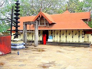
Ayiloor, also known as Ayilur, Aylur, or Ayalur, is a village in the Chittur Thaluk of Palakkad district, state of Kerala, India. Ayiloor is located about 30 kilometers away from Palakkad town and 48 kilometers from Thrissur town.

Kozhinjampara is a town in the Palakkad district, state of Kerala, India alongside the borderline of Tamil Nadu. It forms a part of the area administered by the Kozhinjampara gram panchayat.
Karimpuzha is a gram panchayat in the Palakkad district, in the state of Kerala, India. It is a local government organisation that serves the villages of Karimpuzha-I and Karimpuzha-II.

Marutharode is a census town, gram panchayat and suburb of Palakkad city in the Palakkad district, state of Kerala, India. It is one of Panchayat which is supposed to be part of proposed Palakkad Municipal Corporation.
Palakkad District is one of the main centre of education in Kerala state India. It has Prominent Educational Institutions provide platform for various level of education. The district is home to the only Indian Institute of Technology in Kerala state. Palakkad District has three educational districts namely Palakkad, Ottappalam and Mannarkkad. There are several educational institutions working across the district. Government Victoria College, Palakkad, Government Engineering College, Sreekrishnapuram, NSS College of Engineering, Government Medical College, Palakkad, Chembai Memorial Government Music College, and many more higher level of educational institutions are located in Palakkad District.