St. Anne, Illinois

Last updated

St. Anne, Illinois
St Annes Catholic Church St Annes Illinois.JPG
Shrine and parish church of St. Anne
Nickname: 
St. Anners
Kankakee County Illinois Incorporated and Unincorporated areas St. Anne Highlighted.svg
Location of St. Anne in Kankakee County, Illinois
Illinois in United States (US48).svg
Location of Illinois in the United States
Coordinates: 41°01′23″N87°43′05″W / 41.02306°N 87.71806°W / 41.02306; -87.71806 [1]
CountryUnited States
StateIllinois
County Kankakee
Township St. Anne
Area
[2]
  Total0.86 sq mi (2.23 km2)
  Land0.83 sq mi (2.15 km2)
  Water0.03 sq mi (0.08 km2)
Elevation
[1]
664 ft (202 m)
Population
 (2020)
  Total1,161
  Density1,398.80/sq mi (539.81/km2)
Time zone UTC-6 (CST)
  Summer (DST) UTC-5 (CDT)
ZIP code
60964
Area codes 815 & 779
FIPS code 17-66638
GNIS feature ID2399157 [1]
Wikimedia CommonsSt. Anne, Illinois
Website www.villageofstanne.com

St. Anne (sometimes spelled Saint Anne) [1] is a village in Kankakee County, Illinois, United States. The population was 1,161 at the 2020 census. It is part of the KankakeeBourbonnaisBradley Metropolitan Statistical Area. It was founded in 1851 [3] by Charles Chiniquy, a French-Canadian Catholic priest and friend of the 16th U.S. President Abraham Lincoln who was excommunicated by the Catholic Church in 1856. [4] He later converted to Protestant Christianity, becoming a Presbyterian Evangelical minister and a well-known temperance activist in Canada and the United States. [4]

Contents

Geography

St. Anne is located in southeastern Kankakee County. Illinois Route 1 passes through the west side of the village. It is 13 miles (21 km) southeast of Kankakee, the county seat, and 18 miles (29 km) north of Watseka.

According to the 2010 census, St. Anne has a total area of 0.793 square miles (2.05 km2), of which 0.77 square miles (1.99 km2) (or 97.1%) is land and 0.023 square miles (0.06 km2) (or 2.9%) is water. [5]

Demographics

Historical population
CensusPop.Note
1880 412
1890 71874.3%
1900 1,00039.3%
1910 1,0656.5%
1920 1,0670.2%
1930 1,0781.0%
1940 1,1314.9%
1950 1,40324.0%
1960 1,378−1.8%
1970 1,271−7.8%
1980 1,42111.8%
1990 1,153−18.9%
2000 1,2125.1%
2010 1,2573.7%
2020 1,161−7.6%
U.S. Decennial Census [6]

As of the census [7] of 2000, there were 1,212 people, 464 households, and 330 families residing in the village. The population density was 2,385.3 inhabitants per square mile (921.0/km2). There were 486 housing units at an average density of 956.5 per square mile (369.3/km2). The racial makeup of the village was 89.85% White, 0.83% African American, 0.41% Native American, 0.08% Asian, 0.08% Pacific Islander, 6.60% from other races, and 2.15% from two or more races. Hispanic or Latino of any race were 10.48% of the population.

There were 464 households, out of which 36.9% had children under the age of 18 living with them, 55.0% were married couples living together, 11.2% had a female householder with no husband present, and 28.7% were non-families. 23.3% of all households were made up of individuals, and 11.2% had someone living alone who was 65 years of age or older. The average household size was 2.61 and the average family size was 3.08.

In the village, the population was spread out, with 30.0% under the age of 18, 8.3% from 18 to 24, 28.1% from 25 to 44, 20.2% from 45 to 64, and 13.5% who were 65 years of age or older. The median age was 34 years. For every 100 females, there were 96.4 males. For every 100 females age 18 and over, there were 89.5 males.

The median income for a household in the village was $39,306, and the median income for a family was $41,250. Males had a median income of $32,000 versus $25,086 for females. The per capita income for the village was $16,702. About 11.7% of families and 13.4% of the population were below the poverty line, including 18.2% of those under age 18 and 6.4% of those age 65 or over.

Political affiliation

A majority of St. Anne's is part of Illinois's 2nd congressional district, which is currently represented by Democrat Robin Kelly, though part of the town also falls under Illinois' 16th district and Republican representative Adam Kinzinger. [8]

Education

St. Anne Community High School is the sole high school within the region, and an elementary school also named for the town exists across the street from the high school. The closest institution of higher education to St. Anne is Kankakee Community College.

Transportation

Illinois Route 1, part of the Western route of the historic Dixie Highway, runs north and south in St. Anne. Interstate 57 is the closest interstate highway to St Anne. The town is also located about 5 miles away from the banks of the Iroquois River, which itself connects to the rest of the world through the Mississippi, Illinois, and Kankakee Rivers.

St. Anne has no passenger railroad services of its own, however, Union Pacific Railroad owns freight rail tracks which pass through the city. St. Anne formerly was served by passenger rail, then operated by the New York Central Railroad, the Missouri Pacific Railroad and the Chicago and Eastern Illinois Railroad. [9] [10] [11]

Air transport is limited in St. Anne, with the closest airport being the general aviation-exclusive Kankakee Airport. Commercial air service's closest links to St. Anne are through the two major Chicago airports, with Midway being slightly closer to St. Anne than O'Hare. [12]

Notable people

See also

Related Research Articles

<span class="mw-page-title-main">Kankakee County, Illinois</span> County in Illinois, United States

Kankakee County is a county located in the U.S. state of Illinois. According to the 2020 census, it has a population of 107,502. Its county seat is Kankakee. Kankakee County comprises the Kankakee, IL Metropolitan Statistical Area.

<span class="mw-page-title-main">Hampton, Arkansas</span> Town in Arkansas, United States

Hampton is a town in Calhoun County, Arkansas, United States. The population was 1,181 according to the 2020 United States Census. The town is the county seat of Calhoun County.

<span class="mw-page-title-main">Cabery, Illinois</span> Village in Illinois, United States

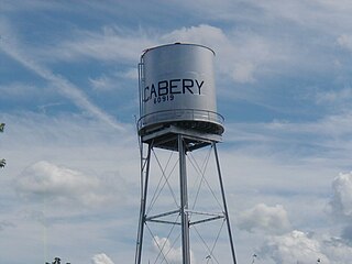
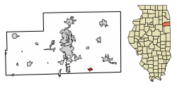
Cabery is a village located in Ford and Kankakee counties in the U.S. state of Illinois. The population was 231 at the 2020 census.

<span class="mw-page-title-main">Liverpool, Illinois</span> Village in Illinois, United States

Liverpool is a village in Fulton County, Illinois, United States. The population was 94 at the 2010 census.

<span class="mw-page-title-main">Beaverville, Illinois</span> Village in Illinois, United States

Beaverville is a village in Beaverville Township, Iroquois County, Illinois, United States. The population was 362 at the 2010 census.

<span class="mw-page-title-main">Chebanse, Illinois</span> Village in Illinois, United States

Chebanse is a village in Iroquois and Kankakee counties in the U.S. state of Illinois. The population was 1,044 at the 2020 census. The Kankakee County portion of Chebanse is included in the Kankakee-Bradley, Illinois Metropolitan Statistical Area.

<span class="mw-page-title-main">Aroma Park, Illinois</span> Village in Illinois, United States

Aroma Park is a village in Kankakee County, Illinois, United States, along the Kankakee River opposite the mouth of the Iroquois River. Aroma Park is a suburb of the city of Kankakee. Aroma Park's population was 743 at the 2010 census, down from 821 at the 2000 census. It is included in the Kankakee-Bradley, Illinois Metropolitan Statistical Area.

<span class="mw-page-title-main">Bonfield, Illinois</span> Village in Illinois, United States

Bonfield is a village in Kankakee County, Illinois, United States. Bonfield's population was 382 at the 2010 census. It is included in the Kankakee-Bradley, Illinois Metropolitan Statistical Area.

<span class="mw-page-title-main">Bradley, Illinois</span> Village in Illinois, United States

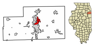
Bradley is a village in Kankakee County, Illinois, United States. It is a suburb of the city of Kankakee. The population was 15,895 at the 2010 census, up from 12,784 at the 2000 census.

<span class="mw-page-title-main">Buckingham, Illinois</span> Village in Illinois, United States

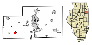
Buckingham is a village in Kankakee County, Illinois, United States. The population was 300 at the 2010 census, up from 237 at the 2000 census. The village is about 63.7 miles south west of Chicago Illinois. It is included in the Kankakee-Bradley, Illinois Metropolitan Statistical Area.

<span class="mw-page-title-main">Essex, Illinois</span> Village in Illinois, United States

Essex is a village in Kankakee County, Illinois, United States. The population was 802 at the 2010 census, up from 554 at the 2000 census. It is included in the Kankakee-Bradley, Illinois Metropolitan Statistical Area.

<span class="mw-page-title-main">Herscher, Illinois</span> Village in Illinois, United States

Herscher is a village in Kankakee County, Illinois, United States. The population was 1,521 at the 2020 census. It is part of the Kankakee–Bradley metropolitan area.

<span class="mw-page-title-main">Hopkins Park, Illinois</span> Village in Illinois, United States

Hopkins Park is a village in Kankakee County, Illinois, United States. The population was 603 at the 2010 census, down from 711 at the 2000 census. It is part of the Kankakee–Bradley Metropolitan Statistical Area.

<span class="mw-page-title-main">Irwin, Illinois</span> Village in Illinois, United States

Irwin is a village in Kankakee County, Illinois, United States. The population was 74 at the 2010 census, down from 92 at the 2000 census. It is included in the Kankakee-Bradley, Illinois Metropolitan Statistical Area.

<span class="mw-page-title-main">Manteno, Illinois</span> Village in Illinois, United States

Manteno is a village in Kankakee County, Illinois, United States. The population was 9,210 at the 2020 census. It is part of the Kankakee-Bourbonnais-Bradley Metropolitan Statistical Area.

<span class="mw-page-title-main">Reddick, Illinois</span> Village in Illinois, United States

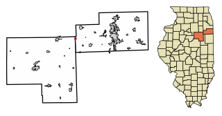
Reddick is a village in Kankakee County, Illinois, United States. A small portion of the village extends into Livingston County. The population was 163 at the 2010 census, down from 219 at the 2000 census.

<span class="mw-page-title-main">Sun River Terrace, Illinois</span> Village in Illinois, United States

Sun River Terrace is a village in Kankakee County, Illinois, United States. The population was 455 at the 2020 census. It is included in the Kankakee-Bradley, Illinois Metropolitan Statistical Area.

<span class="mw-page-title-main">Union Hill, Illinois</span> Village in Illinois, United States

Union Hill is a village in Kankakee County, Illinois, United States. The population was 58 at the 2010 census. It is included in the Kankakee-Bradley, Illinois Metropolitan Statistical Area.

<span class="mw-page-title-main">Tioga, North Dakota</span> City in North Dakota, United States

Tioga is a city in Williams County, North Dakota, United States. The population was 2,202 at the 2020 census.

<span class="mw-page-title-main">Somer Township, Champaign County, Illinois</span> Township in Illinois, United States

Somer Township is a township in Champaign County, Illinois, USA. As of the 2020 census, its population was 988 and it contained 469 housing units.

References

  1. 1 2 3 4 U.S. Geological Survey Geographic Names Information System: St. Anne, Illinois
  2. "2020 U.S. Gazetteer Files". United States Census Bureau. Retrieved March 15, 2022.
  3. Roby, Yves (2000). "Chiniquy, Charles". In English, John (ed.). Dictionary of Canadian Biography Online . Vol. 12. Ottawa: National Archives of Canada and National Library of Canada. ISSN   1709-6812. OCLC   463897210. Archived from the original on October 1, 2012. Retrieved April 27, 2013.
  4. 1 2 Ferland, Catherine (February 1, 2020). "Charles Chiniquy, apôtre spectaculaire de l'abstinence à l'alcool". Aujourd'hui l'histoire (in French). Montreal: Ici Radio-Canada Première . Retrieved May 18, 2022.
  5. "G001 - Geographic Identifiers - 2010 Census Summary File 1". United States Census Bureau. Archived from the original on February 13, 2020. Retrieved December 25, 2015.
  6. "Census of Population and Housing". Census.gov. Retrieved June 4, 2015.
  7. "U.S. Census website". United States Census Bureau . Retrieved January 31, 2008.
  8. Park, Alice; Smart, Charlie; Taylor, Rumsey; Watkins, Miles (February 2, 2021). "An Extremely Detailed Map of the 2020 Election". The New York Times. ISSN   0362-4331 . Retrieved October 20, 2022.
  9. "Freight Rail Map of Class I Carriers in North America - ACW Railway Company". www.acwr.com. Retrieved October 20, 2022.
  10. "RAILROAD OPERATING INFORMATION". www.chicagorailfan.com. Retrieved October 20, 2022.
  11. "History". www.illinirail.com. Retrieved October 20, 2022.
  12. "Airports Near Me - Saint Anne, Illinois | Travelmath". www.travelmath.com. Retrieved October 20, 2022.
  13. "The Rediscovery of Florence Price". The New Yorker . January 29, 2018.