St. Bonifacius, Minnesota

Last updated

Saint Bonifacius
SaintBonifaciusHennepin.png
Location of Saint Bonifacius
within Hennepin County, Minnesota
Country United States
State Minnesota
County Hennepin
Government
   Mayor Kerry Taylor [1]
Area
[2]
  Total1.04 sq mi (2.70 km2)
  Land1.04 sq mi (2.69 km2)
  Water0.00 sq mi (0.00 km2)
Population
 (2020)
  Total2,307
  Density2,220.40/sq mi (857.00/km2)
Time zone UTC-6 (Central (CST))
  Summer (DST) UTC-5 (CDT)
FIPS code 27-56770
Website www.ci.st-bonifacius.mn.us

Saint Bonifacius, often stylized as St. Bonifacius, is a small city in Hennepin County, Minnesota, United States, 25 miles west of Minneapolis. Settled in the 1850s, the town has a combination of rural and exurban features. It is completely surrounded by Minnetrista, Minnesota, and is close to the county line with Carver County. It hosted a Nike Hercules battery during the Cold War, one of four protecting Minneapolis–Saint Paul from Soviet bombers.

Contents

The population was 2,283 at the 2010 census. [3] The Dakota Rail Regional Trail runs through town.

Geography

St. Bonifacius Library 2009-0713-StBonifacius-library.jpg
St. Bonifacius Library
Bridge over Minnesota State Highway 7 in St. Bonifacius, Minnesota, part of the Dakota Rail Regional Trail, a biking and hiking trail Dakota Trail bridge in St Bonifacius.jpg
Bridge over Minnesota State Highway 7 in St. Bonifacius, Minnesota, part of the Dakota Rail Regional Trail, a biking and hiking trail

According to the United States Census Bureau, the city has an area of 1.07 square miles (2.77 km2), of which 1.06 square miles (2.75 km2) is land and 0.01 square miles (0.03 km2) is water. [4] It is completely surrounded by the city of Minnetrista.

Demographics

Historical population
CensusPop.Note
1910 275
1920 33220.7%
1930 3361.2%
1940 3638.0%
1950 43820.7%
1960 57631.5%
1970 68518.9%
1980 85725.1%
1990 1,18037.7%
2000 1,87358.7%
2010 2,28321.9%
2020 2,3071.1%
U.S. Decennial Census
City Hall 2009-0713-StBonifacius-CH.jpg
City Hall
St. Boniface Catholic Church has been in St. Bonifacius for 150 years. 2009-0713-StBonifacius-StBoniface.jpg
St. Boniface Catholic Church has been in St. Bonifacius for 150 years.

2010 census

As of the census [5] of 2010, there were 2,283 people, 863 households, and 624 families living in the city. The population density was 2,153.8 inhabitants per square mile (831.6/km2). There were 912 housing units at an average density of 860.4 per square mile (332.2/km2). The racial makeup of the city was 94.2% White, 1.9% African American, 0.1% Native American, 1.8% Asian, 0.1% Pacific Islander, 0.5% from other races, and 1.4% from two or more races. Hispanic or Latino of any race were 3.2% of the population.

There were 863 households, of which 41.4% had children under the age of 18 living with them, 63.2% were married couples living together, 7.3% had a female householder with no husband present, 1.9% had a male householder with no wife present, and 27.7% were non-families. 20.7% of all households were made up of individuals, and 5.3% had someone living alone who was 65 years of age or older. The average household size was 2.65 and the average family size was 3.12.

The median age in the city was 36.2 years. 28.9% of residents were under the age of 18; 5.2% were between the ages of 18 and 24; 32.1% were from 25 to 44; 25.4% were from 45 to 64; and 8.5% were 65 years of age or older. The gender makeup of the city was 50.9% male and 49.1% female.

2000 census

As of the census [6] of 2000, there were 1,873 people, 681 households, and 546 families living in the city. The population density was 1,756.5 inhabitants per square mile (678.2/km2). There were 695 housing units at an average density of 651.8 per square mile (251.7/km2). The racial makeup of the city was 97.01% White, 0.16% African American, 0.11% Native American, 0.91% Asian, 0.59% from other races, and 1.23% from two or more races. Hispanic or Latino of any race were 1.76% of the population.

There were 681 households, out of which 45.1% had children under the age of 18 living with them, 69.8% were married couples living together, 7.0% had a female householder with no husband present, and 19.8% were non-families. 15.0% of all households were made up of individuals, and 3.7% had someone living alone who was 65 years of age or older. The average household size was 2.75 and the average family size was 3.07.

In the city, the population was spread out, with 29.5% under the age of 18, 6.4% from 18 to 24, 41.1% from 25 to 44, 16.7% from 45 to 64, and 6.5% who were 65 years of age or older. The median age was 32 years. For every 100 females, there were 108.1 males. For every 100 females age 18 and over, there were 107.1 males.

The median income for a household in the city was $65,446, and the median income for a family was $69,938. Males had a median income of $43,173 versus $31,354 for females. The per capita income for the city was $24,933. About 2.8% of families and 3.2% of the population were below the poverty line, including 4.8% of those under age 18 and 2.4% of those age 65 or over.

Politics

Precinct general election results [7]
Year Democratic Republican Third parties
2020 55.2%79742.1% 6082.7% 38
2016 58.1%77732.7% 4379.2% 124
2012 60.1%83137.7% 5212.2% 30
2008 56.8%77041.0% 5562.2% 29
2004 62.5%82536.7% 4850.8% 11
2000 59.1%63535.4% 3805.5% 59
1996 36.9% 25445.6%31417.5% 120
1992 32.6% 18731.1% 17836.3%208
1988 54.0%42746.0% 3640.0% 0
1984 53.1%25146.9% 2220.0% 0
1980 36.0% 16454.4%2489.6% 44
1976 22.7% 8074.4%2622.9% 10
1972 32.2% 9666.1%1971.7% 5
1968 15.5% 4581.4%2373.1% 9
1964 17.9% 5281.4%2370.7% 2
1960 13.4% 3886.6%2460.0% 0

Education

Waconia Public Schools operates the area public schools, [8] including Waconia High School.

Notable person

Related Research Articles

<span class="mw-page-title-main">Shingletown, California</span> Census-designated place in California, United States

Shingletown is a census-designated place (CDP) in Shasta County, California, United States. Its population is 2,442 as of the 2020 census, up from 2,283 from the 2010 census.

<span class="mw-page-title-main">Charlotte Park, Florida</span> Census-designated place in Florida, United States

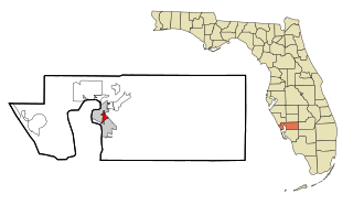
Charlotte Park is a census-designated place (CDP) in Charlotte County, Florida, United States. The population was 2,667 at the 2020 census. It is part of the Sarasota-Bradenton-Punta Gorda Combined Statistical Area.

<span class="mw-page-title-main">Fairbank, Iowa</span> City in Iowa, United States

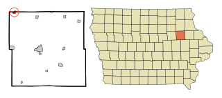
Fairbank is a city in Buchanan and Fayette counties in the U.S. state of Iowa. The population was 1,111 at the time of the 2020 census.

<span class="mw-page-title-main">Garber, Iowa</span> City in Iowa, United States

Garber is a city in Clayton County, Iowa, United States. The population was 76 at the time of the 2020 census, down from 103 in 2000.

<span class="mw-page-title-main">Rexford, Kansas</span> City in Thomas County, Kansas

Rexford is a city in Thomas County, Kansas, United States. As of the 2020 census, the population of the city was 197.

<span class="mw-page-title-main">New Buffalo, Michigan</span> City in Michigan, United States

New Buffalo is a city in Berrien County in the U.S. state of Michigan. The population was 1,883 at the time of the 2010 census and 1,708 at the 2020 census.

<span class="mw-page-title-main">Breen Township, Michigan</span> Civil township in Michigan, United States

Breen Township is a civil township of Dickinson County in the U.S. state of Michigan. As of the 2010 census, the township population was 499, slightly up from 479 at the 2000 census.

Tallmadge Charter Township is a charter township of Ottawa County in the U.S. state of Michigan. The population was 7,575 at the 2010 census.

<span class="mw-page-title-main">Lyon Township, Roscommon County, Michigan</span> Civil township in Michigan, United States

Lyon Township is a civil township of Roscommon County in the U.S. state of Michigan. The population was 1,370 at the 2010 census.

<span class="mw-page-title-main">Victoria, Minnesota</span> City in Minnesota, United States

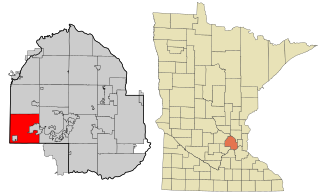
Victoria is a city in Carver County, Minnesota, United States. The population was 10,546 at the 2020 census.

<span class="mw-page-title-main">Waconia, Minnesota</span> City in Minnesota, United States

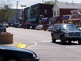
Waconia is a city in Carver County, Minnesota, United States. Waconia attracts visitors to nearby Lake Waconia, a lake locally renowned for its fishing and recreation opportunities.

Waconia Township is a rural township in Carver County, Minnesota, United States. The population was 1,284 as of the 2000 census.

<span class="mw-page-title-main">Minnetrista, Minnesota</span> City in Minnesota, United States

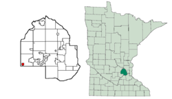
Minnetrista is a city in Hennepin County, Minnesota, United States. Largely rural, Minnetrista has agricultural activity involving corn, soybeans, hay and horses. In addition to farmland and woods, the city is home to several lakes, including part of Lake Minnetonka, the state's ninth-biggest.

<span class="mw-page-title-main">Mound, Minnesota</span> City in Minnesota, United States

Mound is a city in western Hennepin County, Minnesota, United States. The population was 9,052 at the 2010 census. Mound was the birthplace of the Tonka truck that is named after Lake Minnetonka, which the eastern part of town sits on. Mound is 22 miles (35 km) west of Minneapolis, the county seat.

<span class="mw-page-title-main">Henning, Minnesota</span> City in Minnesota, United States

Henning is a city in Otter Tail County, Minnesota, United States. The population was 854 at the 2020 census.

<span class="mw-page-title-main">Leonidas, Minnesota</span> City in Minnesota, United States

Leonidas is a city in Saint Louis County, Minnesota, United States. The population was 52 at the 2010 census.

<span class="mw-page-title-main">New Germany, Minnesota</span> City in Minnesota, United States

New Germany is a city in Carver County, Minnesota, United States. The population was 372 at the 2010 census. A large proportion of the early settlers being natives of Germany caused the name to be selected.

<span class="mw-page-title-main">Hiller, Pennsylvania</span> Census-designated place in Pennsylvania, United States

Hiller is an unincorporated community and census-designated place in Fayette County, Pennsylvania, United States. As of the 2010 census, it had a population of 1,155, down from 1,234 at the 2000 census.

<span class="mw-page-title-main">Wickerham Manor-Fisher, Pennsylvania</span> Census-designated place in Pennsylvania, United States

Wickerham Manor-Fisher is a census-designated place (CDP) in Washington County, Pennsylvania, United States. The population was 1,728 at the 2010 census.

<span class="mw-page-title-main">Pennsboro, West Virginia</span> City in West Virginia, United States

Pennsboro is a city in Ritchie County, West Virginia, United States. The population was 1,050 at the 2020 census. The city is located at the junction of U.S. Route 50 and West Virginia Route 74; the North Bend Rail Trail also passes through the city.

References

  1. "Welcome to Our Website". ci.st-bonifacius.mn.us.
  2. "2020 U.S. Gazetteer Files". United States Census Bureau. Retrieved July 24, 2022.
  3. "2010 Census Redistricting Data (Public Law 94-171) Summary File". American FactFinder. U.S. Census Bureau, 2010 Census. Retrieved April 23, 2011.[ dead link ]
  4. "US Gazetteer files 2010". United States Census Bureau. Archived from the original on February 20, 2011. Retrieved November 13, 2012.
  5. "U.S. Census website". United States Census Bureau . Retrieved November 13, 2012.
  6. "U.S. Census website". United States Census Bureau . Retrieved January 31, 2008.
  7. "Office of the Minnesota Secretary of State – Election Results". Archived from the original on February 22, 2021. Retrieved February 22, 2021.
  8. "Why Waconia". Waconia Public Schools. Retrieved March 28, 2020.

44°54′16″N93°44′38″W / 44.90444°N 93.74389°W / 44.90444; -93.74389