Brant Point Light is a lighthouse located on Nantucket Island. The station was established in 1746, automated in 1965, and is still in operation. The current tower was added to the National Register of Historic Places on October 28, 1987; it has the distinction of being the tenth light on the point, in addition to several range lights. Four of the others burned or blew down, two were condemned, two were unsatisfactory, and the remaining one stands unused.
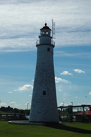
Fort Gratiot Light, the first lighthouse in the state of Michigan, was constructed north of Fort Gratiot in 1829 by Lucius Lyon, who later became one of Michigan's first U.S. Senators.

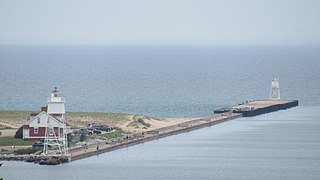
The first Saginaw River lighthouse was constructed from 1839 to 1841, in a period when large quantities of lumber were being harvested and shipped from the heart of Michigan via river and the Great Lakes to the East Coast of the United States via the Erie Canal and Hudson River. This connection to major eastern markets was critical to the development of central Michigan.

Liston Range Rear Lighthouse is a lighthouse in Delaware, United States, on the Delaware River. The 120 feet (37 m) wrought iron tower was made by the Kellogg Bridge Company of Buffalo, New York. The light was built several miles to the east of its present location in 1876–1877, and was moved in 1906. The light was listed on the National Register of Historic Places in 1978. It is the tallest lighthouse in Delaware.

The Craighill Channel Lower Range Rear Light is one of a pair of range lights that marks the first section of the shipping channel into Baltimore harbor. It is the tallest lighthouse in Maryland.
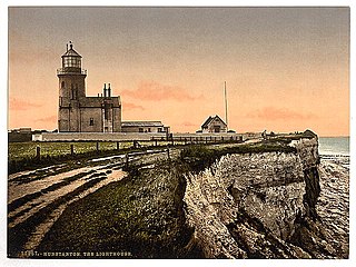
Old Hunstanton Lighthouse is a former lighthouse located in Old Hunstanton in the English county of Norfolk, generally called Hunstanton Lighthouse during its operational life. It was built at the highest point available on this part of the coast, on top of Hunstanton Cliffs, and served to help guide vessels into the safe water of Lynn Deeps. Although the present lighthouse was built in 1840, there had been a lighthouse on the site since the 17th century. Prior to the establishment of the Lynn Well light vessel in 1828, Hunstanton Lighthouse provided the only visible guide to ships seeking to enter The Wash at night.
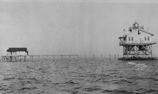
The Parris Island Range Lights were range lights on the southern end of Parris Island in Beaufort County, South Carolina. The Parris Range Lights were first lit in 1881. They were deactivated in 1912. Only the lens house for the Rear Light remains, which is the oldest building at Parris Island.

The Newburyport Harbor Front Range Light is one of two historic range lights in Newburyport, Massachusetts. When it was built in 1873, it was located at Bayley's Wharf, and provided, in combination with the Rear Range Light, a critical aid for navigating into Newburyport's harbor. In 1964 the light was moved to its present location on the grounds of the Merrimack River Coast Guard Station. The stations are no longer in service, but serves as a daymark for arriving mariners.
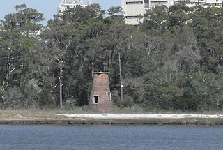
The Price Creek Lighthouse, also known as the Price's Creek Lighthouse, is a structure located near Southport, North Carolina. It was one of two range lights at Price Creek in a series of lights to guide ships from Cape Fear to Wilmington, North Carolina.

The Sand Point Lighthouse is located in Escanaba, Michigan, United States, on Lake Michigan's northern shore. Since 1989, it has been an unofficial aid to navigation. Though it is an operational aid to navigation. The restored lighthouse is now open to the public during the summer months. It is also known as the Escanaba/Sand Point Light or the Escanaba Light.
The Cat Island Light was a lighthouse located on Cat Island off the coast of Mississippi. Originally built to guide shipping through the Mississippi Sound, it was discontinued as traffic moved further south.

The Wood Islands Lighthouse is a historic lighthouse built by Joseph Tomlinson situated on the southeastern shore of Prince Edward Island, located in the community of Wood Islands. The lighthouse is a well-preserved three storey tower with an adjoining 1+1⁄2-storey keeper's residence. The white shingled tower is topped by a red iron lantern, which is enclosed by a white railing on the observation deck. The red roof of the dwelling provides a striking contrast to the white shingled exterior of the dwelling.
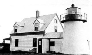
The Hyannis Rear Range Light, also known as the Hyannis Harbor Light, was a lighthouse and, for part of its life, one of a pair of range lights adjacent to Hyannis Harbor. The Range Rear tower was built in 1849 and equipped with a 5th order Fresnel lens in 1856. In 1863 the original birdcage lantern was replaced with a new cast iron one. In 1885, a front range light was added on the Old Colony Railroad Wharf, and the two lights together served to leading vessels to the wharf. The 20 foot Range Rear tower is shorter than most lighthouses, as its purpose was just to guide ships to the wharf. In the early 1800s, the railroad extended from its current terminus at the Hyannis Transportation Center, down what is now Old Colony Road to Harbor Road, where it ended in the 300 foot wharf that was a busy area for shipping coal, lumber, grain and fish.

The Grand Island Harbor Rear Range Light is a lighthouse located off M-28 in Munising Township, Michigan. It is also known as the Bay Furnace Rear Range Light, Christmas Rear Range Light, or End of the Road Light. The corresponding front range light was replaced in 1968; the rear range light was listed on the National Register of Historic Places in 1990. It is no longer an active aid to navigation.
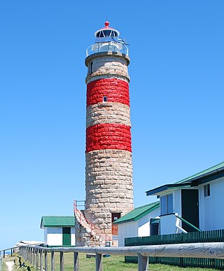
Cape Moreton Light, also listed as North Point Range Rear Light, is a heritage-listed active lighthouse located on Cape Moreton, a rocky headland located at the north eastern tip of Moreton Island, a large sand island on the eastern side of Moreton Bay, on the coast of South East Queensland, Australia. It marks the northern entrance to Moreton Bay and Brisbane and also serves as the rear light for the North Point Range. With its two distinctive red bands, it also serves as a daymark. It is the oldest lighthouse in Queensland, and the only one to be built by the New South Wales Government before the separation of Queensland, which took place in 1859. It is also the only lighthouse in Queensland to be built of stone.
The Green Bay Harbor Entrance Light is an offshore lighthouse near Green Bay, Wisconsin. Located 10 miles (16 km) from the mouth of the Fox River, it was erected to signal the entrance to Green Bay.
The Grand Marais Harbor of Refuge Inner and Outer Lights are a pair of lighthouses located on the west pier at the entry to Grand Marais Harbor of Refuge, in Grand Marais, Michigan. They were listed on the National Register of Historic Places in 2012.

The St. Joseph North Pier Inner and Outer Lights are lighthouses in Michigan at the entrance to the St. Joseph River on Lake Michigan. The station was built in 1832 with the current lights built in 1906 and 1907; they were decommissioned in 2005.

The Keweenaw Waterway Lower Entrance Light, also known as the Portage Entry Light, is a lighthouse located at the south end of breakwater at mouth of the Portage River in Torch Lake Township. It was listed on the National Register of Historic Places in 2014.

The Keweenaw Waterway Upper Entrance Light is a lighthouse located at the north end of the Portage River in McLain State Park in Hancock Township, Michigan. It was listed on the National Register of Historic Places in 2014.