St. Francisville, Illinois

Last updated
St. Francisville, Illinois
St-Francisville-Main-Street-il.jpg
Main Street
Lawrence County Illinois Incorporated and Unincorporated areas St. Francisville Highlighted.svg
Location in Lawrence County, Illinois
Illinois in United States (US48).svg
Location of Illinois in the United States
Coordinates: 38°35′31″N87°38′51″W / 38.59194°N 87.64750°W / 38.59194; -87.64750 Coordinates: 38°35′31″N87°38′51″W / 38.59194°N 87.64750°W / 38.59194; -87.64750 [1]
CountryUnited States
StateIllinois
County Lawrence
Township Denison
Area
[2]
  Total0.78 sq mi (2.02 km2)
  Land0.74 sq mi (1.93 km2)
  Water0.03 sq mi (0.09 km2)
Elevation
[1]
459 ft (140 m)
Population
 (2020)
  Total568
  Density762.42/sq mi (294.39/km2)
Time zone UTC-6 (CST)
  Summer (DST) UTC-5 (CDT)
ZIP Code(s)
62460
Area code 618
FIPS code 17-66833
GNIS feature ID2396489 [1]
Wikimedia CommonsSt. Francisville, Illinois

St. Francisville or Saint Francisville [1] is a city in Lawrence County, Illinois, United States. The population was 697 at the 2010 census. [3]

Contents

History

St. Francisville is rooted in a stockade built by Joseph Tougas in the early 1810s. The city was platted by Tougas's widow in the mid-1830s. It was named for St. Francis Xavier, reflecting the growing influence of Jesuit missionaries in the area. The city incorporated in 1873. [4]

Geography

St. Francisville is located in southeastern Lawrence County in the southeast corner of Denison Township. It is on the west bank of the Wabash River, which forms the state border with Indiana.

The city is 12 miles (19 km) south of Lawrenceville, the county seat. The Wabash Cannon Ball Bridge, 1.5 miles (2.4 km) northeast of St. Francisville, is a former railroad bridge that is now a one-lane toll bridge over the Wabash River which provides the most direct route to Vincennes, Indiana, 9 miles (14 km) to the northeast.

According to the 2010 census, St. Francisville has a total area of 0.784 square miles (2.03 km2), of which 0.75 square miles (1.94 km2) (or 95.66%) is land and 0.034 square miles (0.09 km2) (or 4.34%) is water. [5]

Demographics

Historical population
CensusPop.Note
1860 106
1870 13123.6%
1880 334155.0%
1890 43229.3%
1900 59136.8%
1910 1,391135.4%
1920 1,164−16.3%
1930 1,2023.3%
1940 1,145−4.7%
1950 1,117−2.4%
1960 1,040−6.9%
1970 997−4.1%
1980 1,0404.3%
1990 851−18.2%
2000 759−10.8%
2010 697−8.2%
2020 568−18.5%
U.S. Decennial Census [6]

As of the census [7] of 2000, there were 759 people, 317 households, and 221 families residing in the city. The population density was 1,017.3 inhabitants per square mile (392.8/km2). There were 348 housing units at an average density of 466.4 per square mile (180.1/km2). The racial makeup of the city was 99.21% White, 0.13% African American, and 0.66% from two or more races.

There were 317 households, out of which 34.1% had children under the age of 18 living with them, 52.4% were married couples living together, 12.3% had a female householder with no husband present, and 30.0% were non-families. 27.8% of all households were made up of individuals, and 12.3% had someone living alone who was 65 years of age or older. The average household size was 2.39 and the average family size was 2.89.

In the city, the population was spread out, with 26.0% under the age of 18, 8.2% from 18 to 24, 27.4% from 25 to 44, 22.3% from 45 to 64, and 16.2% who were 65 years of age or older. The median age was 38 years. For every 100 females, there were 92.2 males. For every 100 females age 18 and over, there were 90.5 males.

The median income for a household in the city was $25,543, and the median income for a family was $29,688. Males had a median income of $30,417 versus $15,938 for females. The per capita income for the city was $12,955. About 19.7% of families and 21.1% of the population were below the poverty line, including 41.4% of those under age 18 and 3.2% of those age 65 or over.

As of the census of 2010 the population of St. Francisville was 697. [8]

Economy

St. Francisville is noted for a locally grown variety of popcorn, trademarked as "Black Jewell" for the color of the corn kernels. The popcorn packer attributes the varietal snack food to development work in the "mid 1960s." [9]

Notable person

Related Research Articles

<span class="mw-page-title-main">Clay County, Illinois</span> County in Illinois, United States

Clay County is a county in the U.S. state of Illinois. As of the 2010 United States Census, the population was 13,815. Since 1842, its county seat has been Louisville, in the center of the county's area.

<span class="mw-page-title-main">Wabash County, Indiana</span> County in Indiana, United States

Wabash County is a county located in the northern central part of the U.S. state of Indiana. As of 2020, the population was 30,976. The county seat is Wabash.

<span class="mw-page-title-main">Wabash County, Illinois</span> County in Illinois, United States

Wabash County is a county located in the U.S. state of Illinois. According to the 2020 census, it had a population of 11,361. Its county seat is Mount Carmel. It is located in the southern portion of Illinois known locally as "Little Egypt".

<span class="mw-page-title-main">Lawrence County, Illinois</span> County in Illinois, United States

Lawrence County is the easternmost county in the U.S. state of Illinois. At the 2020 census, the population was 15,280. Its county seat is Lawrenceville.

<span class="mw-page-title-main">Louisville, Illinois</span> Village in Illinois, United States

Louisville is a village in Clay County, Illinois, United States, along the Little Wabash River. The population was 1,136 at the 2020 census. It is the county seat of Clay County.

<span class="mw-page-title-main">Grayville, Illinois</span> City in Illinois, United States

Grayville is a city in Edwards and White counties in the U.S. state of Illinois. As of the 2020 census, the city's population was 1,550, down from 1,666 at the 2010 census. Grayville is the birthplace of naval hero James Meredith Helm.

<span class="mw-page-title-main">New Haven, Illinois</span> Village in Illinois, United States

New Haven is a village in Gallatin County, Illinois, United States, along the Little Wabash River near its mouth at the Wabash River. The population was 433 at the 2010 United States Census, down from 477 at the 2000 census.

<span class="mw-page-title-main">Ridgway, Illinois</span> Village in Illinois, United States

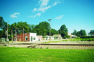
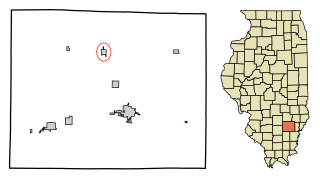
Ridgway is a village in Gallatin County, Illinois, United States. As of the 2020 census, the population was 851. As of 2018, Rebecca Mitchell was the town mayor.

<span class="mw-page-title-main">Ste. Marie, Illinois</span> Village in Illinois, United States

Ste. Marie is a village in Jasper County, Illinois, United States, along the Embarras River. The population was 244 at the 2010 census.

<span class="mw-page-title-main">Forrest, Illinois</span> Village in Illinois, United States

Forrest is a village in Livingston County, Illinois, United States. The population was 1,220 at the 2010 census.

<span class="mw-page-title-main">Bellmont, Illinois</span> Village in Illinois, United States

Bellmont is a village in Bellmont Precinct, Wabash County, Illinois, United States. The population was 297 at the 2000 census.

<span class="mw-page-title-main">Keensburg, Illinois</span> Village in Illinois, United States

Keensburg is a village in Coffee Precinct, Wabash County, Illinois. The population was 192 at the 2010 census.

<span class="mw-page-title-main">Golden Gate, Illinois</span> Village in Illinois, United States

Golden Gate is a village in Wayne County, Illinois, along the Little Wabash River. The population was 65 at the 2020 census.

<span class="mw-page-title-main">Carmi, Illinois</span> City in Illinois, United States

Carmi is a city in and the county seat of White County, Illinois, United States, along the Little Wabash River, where the population was 5,240 at the 2010 census.

<span class="mw-page-title-main">Wabash, Indiana</span> City in Indiana, United States

Wabash is a city in Noble Township, Wabash County, in the U.S. state of Indiana. The population was 10,666 at the 2010 census. The city is the county seat of Wabash County.

<span class="mw-page-title-main">State Line City, Indiana</span> Town in Indiana, United States

State Line City is a town in Kent Township, Warren County, Indiana, United States, situated along the state's boundary with Illinois. As of the 2010 census, the town population was 143.

<span class="mw-page-title-main">Jewell Junction, Iowa</span> City in Iowa, United States

Jewell Junction, better known as Jewell, is a city in Hamilton County, Iowa, United States. The population was 1,216 at the time of the 2020 census.

<span class="mw-page-title-main">Silver City, Iowa</span> City in Iowa, United States

Silver City is a city in Mills County, Iowa, United States. The population was 245 at the 2020 census. The Wabash Trace—a railroad converted to a bicycle trail—passes through here. At trailside, there is a small park with a gazebo, and across from it, a small cafe.

<span class="mw-page-title-main">Selby Township, Bureau County, Illinois</span> Township in Illinois, United States

Selby Township is one of twenty-five townships in Bureau County, Illinois, USA. As of the 2020 census, its population was 2,152 and it contained 929 housing units.

<span class="mw-page-title-main">Mahomet Township, Champaign County, Illinois</span> Township in Illinois, United States

Mahomet Township is a township in Champaign County, Illinois, USA. As of the 2020 census, its population was 13,697 and it contained 5,391 housing units.

References

  1. 1 2 3 4 U.S. Geological Survey Geographic Names Information System: St. Francisville, Illinois
  2. "2020 U.S. Gazetteer Files". United States Census Bureau. Retrieved March 15, 2022.
  3. "Profile of General Population and Housing Characteristics: 2010 Census Summary File 1 (DP-1), St. Francisville city, Illinois". American FactFinder. U.S. Census Bureau. Retrieved January 9, 2020.[ permanent dead link ]
  4. Edward Callary, Place Names of Illinois (University of Illinois Press, 2010), p. 333.
  5. "G001 - Geographic Identifiers - 2010 Census Summary File 1". United States Census Bureau. Archived from the original on 2020-02-13. Retrieved 2015-12-27.
  6. "Census of Population and Housing". Census.gov. Retrieved June 4, 2015.
  7. "U.S. Census website". United States Census Bureau . Retrieved 2008-01-31.
  8. "2010 US Census Data". Archived from the original on 2014-01-10. Retrieved 2014-01-10.
  9. "Black Jewell: American Grown/American Owned". Black Jewell Popcorn Inc. Retrieved 2012-08-24.