
Bermuda is a British Overseas Territory in the North Atlantic Ocean. It is about 1,035 km (643 mi) east-southeast of Cape Hatteras, North Carolina ; 1,236 km (768 mi) south of Cape Sable Island, Nova Scotia; 1,759 km (1,093 mi) northeast of Cuba, and 1,538 km (956 mi) due north of the British Virgin Islands. Though typically referred to in the singular, Bermuda has 181 islands; the largest of these being Main Island. Bermuda's capital city is Hamilton. Bermuda is internally self-governing, with its constitution and cabinet of ministers selected from the elected Members of the lower house of a Parliament that enacts local laws. As the national government, the Government of the United Kingdom is ultimately responsible for ensuring good governance within British Overseas Territories, and retains responsibility for defence and foreign relations. As of July 2018, it has a population of 71,176, making it the most populous of the British overseas territories. Bermuda's largest industries are offshore insurance, reinsurance, and tourism. Bermuda had one of the world's highest GDP per capita for most of the 20th century.

Bermuda is an overseas territory of the United Kingdom in the North Atlantic Ocean. Located off the east coast of the United States, it is situated around 1,770 km (1,100 mi) northeast of Miami, Florida and 1,350 km (840 mi) south of Halifax, Nova Scotia, west of Portugal, northwest of Brazil, 1,759 km (1,093 mi) north of Cuba and north-northeast of Puerto Rico. The nearest landmass is Cape Hatteras, North Carolina, about 1,030 km (640 mi) west-northwest. Although commonly referred to in the singular, the territory consists of approximately 138 islands, with a total area of 57 km2 (22 sq mi).

St. George's, located on the island and within the parish of the same names, settled in 1612, is the first permanent English settlement on the islands of Bermuda. It is often described as the third successful British settlement in the Americas, after St. John's, Newfoundland, and Jamestown, Virginia and the oldest continuously-inhabited British town in the New World, since the other two settlements were seasonal for a number of years.

Sandys Parish ( "sands") is one of the nine parishes of Bermuda. It is named for English aristocrat Sir Edwin Sandys (1561–1629), and hence there is no apostrophe in the name.

Southampton Parish is one of the nine parishes of Bermuda. It is named for Henry Wriothesley, 3rd Earl of Southampton (1573-1624).

Warwick Parish is one of the nine parishes of Bermuda. It is named after Robert Rich, 2nd Earl of Warwick (1587-1658).
Paget Parish is one of the nine parishes of Bermuda. It is named for William Paget, 4th Baron Paget de Beaudesert (1572–1629).
Pembroke Parish is one of the nine parishes of Bermuda. It is named after English aristocrat William Herbert, 3rd Earl of Pembroke (1580–1630).

Devonshire Parish is one of the nine parishes of Bermuda. Originally named Cavendish Tribe and later Devonshire Tribe, for William Cavendish, 1st Earl of Devonshire (1552–1626). Devonshire Redoubt, on Castle Island, one of the Castle Harbour fortifications of St. George's Parish, was also named after him.

Hamilton Parish is one of the nine parishes of Bermuda. It was renamed for Scottish aristocrat James Hamilton, 2nd Marquess of Hamilton (1589-1625) when he purchased the shares originally held in the Virginia Company by Lucy Russell, Countess of Bedford.
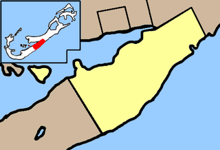
St. George's Parish is one of the nine parishes of Bermuda. It is named after the founder of the Bermuda colony, Admiral Sir George Somers.

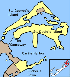
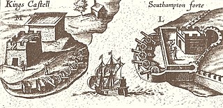
Castle Harbour is a large natural harbour in Bermuda. It is located between the northeastern end of the main island and St. David's Island. Originally called Southampton Port, it was renamed as a result of its heavy fortification in the early decades of the Seventeenth century.

St. George's Harbour is a natural harbour in the north of Bermuda. It serves as the port for the town of St. George's, located on St. George's Island, to its north. To its south is St. David's Island. The harbour and both islands lie within St. George's Parish. It was for two centuries the primary harbour of the British Overseas Territory.
St. David's Island is one of the main islands of the British Overseas Territory of Bermuda. It is located in the far north of the territory, one of the two similarly sized islands that make up the majority of St. George's Parish.
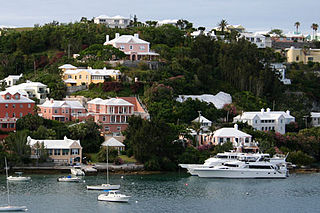
The architecture of Bermuda has developed over the past four centuries. The archipelago's isolation, environment, climate, and scarce resources have been key driving points, though inspiration from Europe, the Caribbean and the Americas is evident. Distinctive elements appeared with initial settlement in the early 17th century, and by the second half of that century features that remain common today began to appear.
Castle Roads is the primary channel by which vessels enter Castle Harbour, Bermuda, from the Atlantic Ocean. Although little used, today, except by pleasure boats, Castle Harbour was once an important anchorage, and an access route used by ships to reach the still important St. George's Harbour. The infilling of waterways between St. David's Island and Long Bird Island in the 1940s, as well as the Causeway joining the contiguous landmass so created means only small boats can pass between the two Harbours, today. It was once common to use the term roads in reference to a waterway. Other examples include Hampton Roads, in Virginia, and Lahaina Roads, in Hawaii.

The Bermuda Garrison was the military establishment maintained on the British Overseas Territory of Bermuda by the regular British Army, and its local militia and voluntary reserves from 1701 to 1957. The garrison evolved from an independent company, to a company of Royal Garrison Battalion during the American War of Independence, and a steadily growing and diversifying force of artillery and infantry with various supporting corps from the French Revolution onwards. During the American War of Independence, the garrison in Bermuda fell under the military Commander-in-Chief of North America. Subsequently, it was part of the Nova Scotia Command until 1868, and was an independent Bermuda Command from then 'til its closure in 1957.

Fort St. Catherine, or Fort St. Catherine's, is a coastal artillery fort at the North-East tip of St. George's Island, Bermuda. Successively redeveloped, the fort was used first by Bermudian Militia and then by regular Royal Artillery units from 1612 into the 20th century. Today it houses a museum.

The Historic Town of St George and Related Fortifications is the name used by the United Nations Educational, Scientific and Cultural Organization's (UNESCO) World Heritage Committee to identify collectively as a World Heritage site St. George's Town, founded in 1612, and a range of fortifications, batteries, and magazines built between 1612 and 1939, the last of which was removed from use in 1953.

Fort Victoria is a disused British Army fort, built to house coastal artillery atop Retreat Hill at the North-East of St. George's Island, in the British colony of Bermuda.


