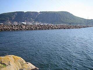
The Canso Causeway is a 1,385 m (4,544 ft) rock-fill causeway in Nova Scotia, Canada.

The Florida Keys are a coral cay archipelago located off the southern coast of Florida, forming the southernmost part of the continental United States. They begin at the southeastern coast of the Florida peninsula, about 15 miles (24 km) south of Miami, and extend in a gentle arc south-southwest and then westward to Key West, the westernmost of the inhabited islands, and on to the uninhabited Dry Tortugas. The islands lie along the Florida Straits, dividing the Atlantic Ocean to the east from the Gulf of Mexico to the northwest, and defining one edge of Florida Bay. At the nearest point, the southern part of Key West is just 90 miles (140 km) from Cuba. The Florida Keys are between about 24.3 and 25.5 degrees North latitude.
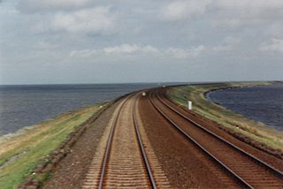
A causeway is a track, road or railway on the upper point of an embankment across "a low, or wet place, or piece of water". It can be constructed of earth, masonry, wood, or concrete. One of the earliest known wooden causeways is the Sweet Track in the Somerset Levels, England, which dates from the Neolithic age. Timber causeways may also be described as both boardwalks and bridges.

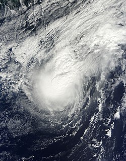
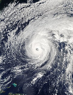
Hurricane Fabian was a powerful Cape Verde hurricane that impacted Bermuda in early September during the 2003 Atlantic hurricane season. It was the sixth named storm, fourth hurricane, and first major hurricane of the season, developed from a tropical wave in the tropical Atlantic Ocean on August 25. It moved west-northwestward under the influence of the subtropical ridge to its north, and steadily strengthened in an area of warm sea surface temperatures and light wind shear. The hurricane attained a peak intensity of 145 mph (230 km/h) on September 1, and it slowly weakened as it turned northward. On September 5, Fabian made a direct hit on Bermuda with wind speeds of over 120 mph (195 km/h). After passing the island, the hurricane turned to the northeast, and became extratropical on September 8, before dissipating two days later.
The article covers the Hurricane Katrina effects by region, within the United States and Canada. The effects of Hurricane Katrina, in late August 2005, were catastrophic and widespread. It was one of the deadliest natural disasters in U.S. history, leaving at least 1,836 people dead, and a further 135 missing. The storm was large and had an effect on several different areas of North America.

Hamilton Parish is one of the nine parishes of Bermuda. It was renamed for Scottish aristocrat James Hamilton, 2nd Marquess of Hamilton (1589-1625) when he purchased the shares originally held in the Virginia Company by Lucy Russell, Countess of Bedford.
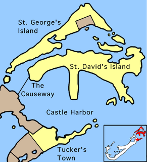
St. George's Parish is one of the nine parishes of Bermuda. It is named after the founder of the Bermuda colony, Admiral Sir George Somers.

Hamilton Harbour is a natural harbour in Bermuda which serves as the port for the capital, the City of Hamilton. It is an arm of the Great Sound, and forms a tapering wedge shape of water between Paget Parish and the peninsula which forms Pembroke Parish, and upon which the capital sits.

Card Sound Bridge is a high-rise toll causeway connecting southern Miami-Dade County and northern Monroe County. It is one of only two ways that motorists can leave or enter the Florida Keys. The toll for two-axle automobiles is USD $1.50 if paid via SunPass. The prior toll plaza was demolished during hurricane Matthew and has been replaced with a toll-by-plate plaza. The toll fee will be charged by plate automatically and sent via the mail to the address on the vehicle registration. The cashless all-electronic tolling system replaced the previous manned toll booth on October 20, 2018. The toll fee is waived upon evacuating the Keys for hurricanes or in instances in which US 1 is impassable.

Hurricane Florence was the first North Atlantic hurricane to produce hurricane-force winds on the island of Bermuda since Hurricane Fabian in September 2003. The seventh tropical storm and second hurricane of the 2006 Atlantic hurricane season, Florence developed from a tropical wave in the eastern Atlantic Ocean on September 3. Due to unfavorable conditions, the system failed to organize initially, and as a result, the storm grew to an unusually large size. After several days, Florence encountered an area of lesser wind shear and intensified into a hurricane on September 10. It passed just west of Bermuda while recurving northeastward, and on September 13 it transitioned into an extratropical cyclone.
The British Overseas Territory of Bermuda has been affected by several tornadoes and waterspouts in its history.

The George and Cynthia Mitchell Memorial Causeway is a set of causeways in Galveston, Texas, United States. Two of the routes carry the southbound and northbound traffic of Interstate 45, while the original causeway is restricted to rail traffic. It is the main roadway access point to Galveston Island. The second access point is Bolivar Ferry.

The following is an alphabetical list of topics related to the British Overseas Territory of the Bermuda Islands.

Hurricane Igor was a very large Cape Verde hurricane and the most destructive tropical cyclone on record to strike the Canadian island of Newfoundland. It originated from a broad area of low pressure that moved off the western coast of Africa on September 6, 2010. Tracking slowly westward, it developed into a tropical depression on September 8 and strengthened into a tropical storm shortly thereafter. Higher wind shear temporarily halted intensification over the following days. On September 12, however, explosive intensification took place, and Igor reached Category 4 status on the Saffir–Simpson hurricane wind scale. By this time, Igor had already begun a prolonged turn around the western periphery of the subtropical ridge. After becoming the strongest cyclone of the season, with maximum sustained winds of 155 mph (250 km/h), it began to enter an area for continued strengthening. Igor gradually weakened before brushing Bermuda as a minimal hurricane on September 20. After turning northeastward, the system began an extratropical transition, which it completed shortly after striking southern Newfoundland. The remnants of Igor were later absorbed by another extratropical cyclone over the Labrador Sea on September 23.

Hurricane Gonzalo was the second tropical cyclone, after Hurricane Fay, to directly strike the island of Bermuda in a one-week time frame in October 2014, and was the first Category 4 Atlantic hurricane since Hurricane Ophelia in 2011. At the time, it was the strongest hurricane in the Atlantic since Igor in 2010. Gonzalo struck Bermuda less than a week after the surprisingly fierce Hurricane Fay; 2014 was the first season in recorded history to feature two hurricane landfalls in Bermuda. A powerful Atlantic tropical cyclone that wrought destruction in the Leeward Islands and Bermuda, Gonzalo was the seventh named storm, sixth and final hurricane and only the second major hurricane of the below-average 2014 Atlantic hurricane season. The storm formed from a tropical wave on October 12, while located east of the Lesser Antilles. It made landfall on Antigua, Saint Martin, and Anguilla as a Category 1 hurricane, causing damage on those and nearby islands. Antigua and Barbuda sustained US$40 million in losses, and boats were abundantly damaged or destroyed throughout the northern Leeward Islands. The storm killed three people on Saint Martin and Saint Barthélemy. Gonzalo tracked northwestward as it intensified into a major hurricane. Eyewall replacement cycles led to fluctuations in the hurricane's structure and intensity, but on October 16, Gonzalo peaked with maximum sustained winds of 145 mph (235 km/h).
Hurricane Fay was the first hurricane to make landfall on Bermuda since Emily in 1987. The sixth named storm and fifth hurricane of the 2014 Atlantic hurricane season, Fay evolved from a broad disturbance several hundred miles northeast of the Lesser Antilles on October 10. Initially a subtropical cyclone with an expansive wind field and asymmetrical cloud field, the storm gradually attained tropical characteristics as it turned north, transitioning into a tropical storm early on October 11.
Hurricane Nicole was the first major hurricane to directly impact Bermuda since Hurricane Fabian in 2003 as equally one of the strongest hurricanes to do so. The fourteenth named storm, sixth hurricane and third major hurricane of the 2016 Atlantic hurricane season, Nicole formed in the central Atlantic on October 4. The small, slow-moving storm defied forecasts by steadily organizing in spite of strong wind shear, and it rapidly intensified to a Category 2 hurricane on October 7. The wind shear finally took its toll by October 8, reducing Nicole to a minimal tropical storm, as a building high pressure system forced the storm southwards. Intensification began once again as the storm retreated towards Bermuda, and Nicole reached its peak intensity early on October 13 as a Category 4 hurricane with 140 mph (220 km/h) winds. Shortly thereafter, increased vertical wind shear weakened the storm to Category 3 status, and the eye of the storm passed over Bermuda later that day. Afterwards, Nicole accelerated northeastwards while gradually weakening, but significantly expanding in size as it traversed the Northern Atlantic. By October 18, decreasing sea surface temperatures caused the large hurricane to become extratropical as it accelerated northwards towards Greenland.

Hurricane Humberto was a large and powerful tropical cyclone that caused extensive wind damage in Bermuda during September 2019. It was the eighth named storm, third hurricane, and second major hurricane – Category 3 or higher on the Saffir–Simpson scale – of the 2019 Atlantic hurricane season. Humberto formed on September 13 from the prolonged interaction of a tropical wave and an upper-level trough, then paralleled the eastern coastline of Florida through September 16 before turning sharply northeastward. A generally favorable environment allowed Humberto to become a hurricane that day, and the storm further strengthened to reach peak intensity as a Category 3 hurricane on September 18. After its center passed within 65 miles (100 km) of Bermuda around 00:00 UTC on September 19, the system encountered stronger wind shear and drier air. Stripped of its deep thunderstorm activity, the system transitioned to a potent extratropical cyclone early on September 20.


