Somerset DrawbridgeSomerset Drawbridge center with 32 inch bisected plank opened by hand to allow the passage of sailboat masts
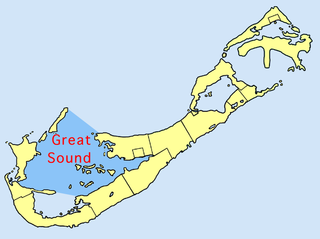
Somerset Bridge is a small bridge in Bermuda connecting Somerset Island with the mainland in the western parish of Sandys, Somerset Bridge is reputedly the smallest working drawbridge in the world. It crosses a small channel connecting the Great Sound with Ely's Harbour.
The bridge is mentioned in the acts of Bermuda's first parliament, held in St. George's on 1 August 1620. Bridges were to be constructed at Somerset, the Flatts, and Coney Island. Additionally, the road from Somerset to Warwick was to be improved, and extended to Castle Point.[1] The bridge appears on a 1624 map of Bermuda.[2]
The bridge is opened by hand, creating a 32-inch gap that allows the passage of a sailboat's mast. The drawbridge is depicted on a Bermudian banknote.[3]
Notes
↑ Wilkinson, Henry (1958). The Adventurers of Bermuda (Seconded.). New York: Oxford University Press. pp.138–140.
↑ Harris, Edward (1997). Bermuda Forts, 1612-1957 (Firsted.). Bermuda Maritime Museum Press. p.47.
A causeway is a track, road or railway on the upper point of an embankment across "a low, or wet place, or piece of water". It can be constructed of earth, masonry, wood, or concrete. One of the earliest known wooden causeways is the Sweet Track in the Somerset Levels, England, which dates from the Neolithic age. Timber causeways may also be described as both boardwalks and bridges.
Sandys Parish ( "sands") is one of the nine parishes of Bermuda. It is named for English aristocrat Sir Edwin Sandys (1561–1629), and hence there is no apostrophe in the name.
Warwick Parish is one of the nine parishes of Bermuda. It is named after Robert Rich, 2nd Earl of Warwick (1587-1658).
St. George's Parish is one of the nine parishes of Bermuda. It is named after the founder of the Bermuda colony, Admiral Sir George Somers.
Ireland Island is the north-westernmost island in the chain which comprises Bermuda. It forms a long finger of land pointing northeastwards from the main island, the last link in a chain which also includes Boaz Island and Somerset Island. It lies within Sandys Parish, and forms the northwestern coast of the Great Sound. It is regarded as one of the six principal islands of Bermuda, and part of the West End of the archipelago.
The Great Sound is large ocean inlet located in Bermuda. It may be the submerged remains of a Pre-Holocene volcanic caldera. Other geologists dispute the origin of the Bermuda Pedestal as a volcanic hotspot.
Darrell's Island is a small island within the Great Sound of Bermuda. It lies in the southeast of the sound, and is in the north of Warwick Parish. The island is owned by the Bermuda Government.
Hinson's Island is a small island within the Great Sound of Bermuda. It lies in the southeast of the sound, and is part of Paget parish, although it was formerly part of Warwick Parish and is still within the Warwick North constituency.
Flatts Village is a small settlement in Bermuda, lying on the southern bank of Flatt's Inlet in Hamilton Parish, almost exactly between the territory's two incorporated municipalities, Hamilton and St. George's.
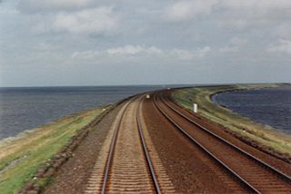
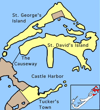
The Causeway is a narrow strip of reclaimed land and bridges in the north of Bermuda linking Hamilton Parish on the mainland in the southwest and Bermuda International Airport on St. David's Island in St. George's Parish in the northeast, which are otherwise divided by Castle Harbour.
Castle Harbour is a large natural harbour in Bermuda. It is located between the northeastern end of the main island and St. David's Island. Originally called Southampton Port, it was renamed as a result of its heavy fortification in the early decades of the Seventeenth century.
Castle Island is part of the chain which makes up Bermuda. It is located in St. George's Parish, in the northeast of the territory.
The following is a list of places of interest in Bermuda.
The Bermuda Railway was a 21.7-mile (34.9 km) common carrier line that operated in Bermuda for a brief period. In its 17 years of existence, the railway provided frequent passenger and freight service over its length spanning most of the archipelago from St. George's in the east to Somerset, Sandys Parish, in the west.
The Bonita Beach Causeway is a causeway with a series of four low-level bridges located in Southwest Florida traversing the barrier islands of Estero Bay connecting the town of Fort Myers Beach with Bonita Springs. It carries Estero Boulevard and is 4.1 miles (6.6 km) long from end to end. Each bridge on the Bonita Beach Causeway is named after the body of water it crosses.
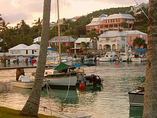
Somerset Village is a small, unincorporated village in the northwest area of Bermuda, located in Sandys Parish. It lies in the northern half of Somerset Island.
Several of the islands strung across the South entrance of Castle Harbour, Bermuda were fortified in the early days of the territory, hence the harbour's name. When official settlement of the archipelago by England began in 1612 the first permanent town, St. George's was placed on the North side of St. George's Harbour. St. George's Harbour could be accessed directly by channels from the East. Those channels, however, were shallow, suitable, originally, only for small ships. As a consequence, and despite any major settlement on its shores, Castle Harbour was an important anchorage in the early years of the colony, with its main entrance, Castle Roads being an important route in from the open Atlantic for shipping. It was also a weak point, as it was remote from the defences of St. George's Harbour, and difficult to reach. It was quickly fortified and garrisoned by a standing militia.
Watford Island is an island of Bermuda.
Bailey's Bay is a long shallow indentation in the northeastern shore of the main island of Bermuda. It stretches for about 1,500 metres (1,600 yd) along the north coast of Hamilton Parish. The settlement which stretches along the bay's coast is also called Bailey's Bay.
Ely's Harbour is a natural harbour on the west coast of Bermuda.
This page is based on this Wikipedia article Text is available under the CC BY-SA 4.0 license; additional terms may apply. Images, videos and audio are available under their respective licenses.