Postcodes for street addresses consist of two letters and two digits, as follows:
Mr. & Mrs Householder
Upper Apt # 1
9 Leafy Lane
SMITH'S FL 07
BERMUDA
Postcodes for PO Box addresses, however, consist of four letters. In the capital, Hamilton, a PO Box address would be:
Mr. Boxholder
PO Box HM 2469
HAMILTON HM GX
BERMUDA
In Hamilton, each PO Box number range has a different postcode, while postcodes for PO Box addresses in the rest of Bermuda will always end in BX, for example:
A postal code is a series of letters or digits or both, sometimes including spaces or punctuation, included in a postal address for the purpose of sorting mail.
A ZIP Code is a postal code used by the United States Postal Service (USPS). Introduced in 1963, the basic format consisted of five digits. In 1983, an extended ZIP+4 code was introduced; it included the five digits of the ZIP Code, followed by a hyphen and four digits that designated a more specific location.
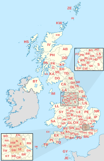
Postal codes used in the United Kingdom, British Overseas Territories and Crown Dependencies are known as postcodes. They are alphanumeric and were adopted nationally between 11 October 1959 and 1974, having been devised by the General Post Office. A full postcode is known as a "postcode unit" and designates an area with several addresses or a single major delivery point.
The London postal district is the area in England of 241 square miles (620 km2) to which mail addressed to the London post town is delivered. The General Post Office under the control of the Postmaster General directed Sir Rowland Hill to devise the area in 1856 and throughout its history it has been subject to reorganisation and division into increasingly smaller postal units, with the early loss of two compass points and a minor retraction in 1866. It was integrated by the Post Office into the national postcode system of the United Kingdom during the early 1970s and corresponds to the N, NW, SW, SE, W, WC, E and EC postcode areas. The postal district has also been known as the London postal area. The County of London was much smaller, at 117 square miles (300 km2), but Greater London is much larger at 607 square miles (1,570 km2).
Poste restante, also known as general delivery in North American English, is a service where the post office holds the mail until the recipient calls for it. It is a common destination for mail for people who are visiting a particular location and have no need, or no way, of having mail delivered directly to their place of residence at that time.
Postcodes in New Zealand consist of four digits, the first two of which specify the area, the third the type of delivery, and the last the specific lobby, RD number, or suburb. The present postcode system was introduced in New Zealand in June 2006, which, unlike the previous system, applies to all items of mail with effect from June 2008. In October 2008, New Zealand Post launched a 'remember your postcode' campaign, offering a NZ$10,000 prize for remembering a postcode.
The British Forces Post Office (BFPO) provides a postal service to HM Forces, separate from that provided by Royal Mail in the United Kingdom. BFPO addresses are used for the delivery of mail in the UK and around the world. BFPO moved from its original base at Inglis Barracks, Mill Hill to its current base at RAF Northolt in northwest London in 2007.
Postal codes were introduced in South Africa on 8 October 1973, with the introduction of automated sorting.
Postal codes were introduced in France in 1964, when La Poste introduced automated sorting. They were updated to use the current 5 digit system in 1972.
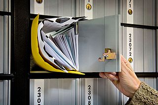
A post office box is a uniquely addressable lockable box located on the premises of a post office.
An address is a collection of information, presented in a mostly fixed format, used to give the location of a building, apartment, or other structure or a plot of land, generally using political boundaries and street names as references, along with other identifiers such as house or apartment numbers and organization name. Some addresses also contain special codes, such as a postal code, to make identification easier and aid in the routing of mail.
A post town is a required part of all postal addresses in the United Kingdom and Ireland, and a basic unit of the postal delivery system. Including the correct post town in the address increases the chance of a letter or parcel being delivered on time. Post towns in general originated as the location of delivery offices. As of 2004, their main function is to distinguish between localities or street names in addresses not including a postcode.
A "postal address" in the Republic of Ireland is a place of delivery defined by Irish Standard (IS) EN 14142-1:2011 and serviced by the universal service provider, An Post. Its addressing guides comply with the guidelines of the Universal Postal Union (UPU), the United Nations-affiliated body responsible for promoting standards in the postal industry, across the world.
The NW postcode area, also known as the London NW postcode area, is a group of 13 postcode districts covering around 13,895 live postcodes within part of northwest London, England. It is the successor of the NW sector, originally created as part of the London postal district in 1856.
The N (Northern) postcode area, also known as the London N postcode area, is the part of the London post town covering part of North London, England. It is a group of 25 postcode districts which covers around 17,429 live postcodes.
The SW postcode area, also known as the London SW postcode area, is a group of 20 postcode districts within the London post town in England. The area comprises the South Western operational district and the Battersea operational district, and is the only area within the London post town to lie on both sides of the River Thames.
Postcodes in Australia are used to more efficiently sort and route mail within the Australian postal system. Postcodes in Australia have four digits and are placed at the end of the Australian address, before the country. Postcodes were introduced in Australia in 1967 by the Postmaster-General's Department and are now managed by Australia Post, Australia's national postal service. Postcodes are published in booklets available from post offices or online from the Australia Post website.
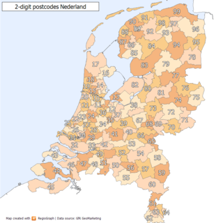
Postal codes in the Netherlands, known as postcodes, are alphanumeric, consisting of four digits followed by two uppercase letters. The letters 'F', 'I', 'O', 'Q', 'U' and 'Y' were originally not used for technical reasons, but almost all existing combinations are now used as these letters were allowed for new locations starting 2005. The letter combinations 'SS', 'SD' and 'SA' are not used because of their associations with the Nazi occupation of the Netherlands.
Postal codes used in Saudi Arabia are known as post code, postal codes, PIN/ ZIP code, consisting of a specific number of digits, alphabets, spaces and sometimes punctuations.
This page is based on this Wikipedia article Text is available under the CC BY-SA 4.0 license; additional terms may apply. Images, videos and audio are available under their respective licenses.