Related Research Articles

A postal code is a series of letters or digits or both, sometimes including spaces or punctuation, included in a postal address for the purpose of sorting mail.
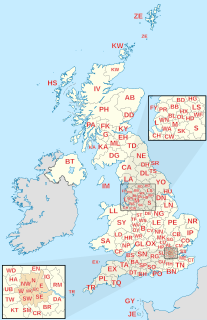
Postal codes used in the United Kingdom, British Overseas Territories and Crown dependencies are known as postcodes. They are alphanumeric and were adopted nationally between 11 October 1959 and 1974, having been devised by the General Post Office. A full postcode is known as a "postcode unit" and designates an area with several addresses or a single major delivery point.

The London postal district is the area in England of 241 square miles (620 km2) to which mail addressed to the London post town is delivered. The General Post Office under the control of the Postmaster General directed Sir Rowland Hill to devise the area in 1856 and throughout its history it has been subject to reorganisation and division into increasingly smaller postal units, with the early loss of two compass points and a minor retraction in 1866. It was integrated by the Post Office into the national postcode system of the United Kingdom during the early 1970s and corresponds to the N, NW, SW, SE, W, WC, E and EC postcode areas. The postal district has also been known as the London postal area. The County of London was much smaller, at 117 square miles (300 km2), but Greater London is much larger at 607 square miles (1,570 km2).

The postal counties of the United Kingdom, now known as former postal counties, were postal subdivisions in routine use by the Royal Mail until 1996. The purpose of the postal county – as opposed to any other kind of county – was to aid the sorting of mail by differentiating between like-sounding post towns. Since 1996 this has been done by using the outward code of the postcode instead. For operational reasons the former postal counties, although broadly based on the counties of the United Kingdom, did not match up with their boundaries: in some cases there were significant differences. The boundaries changed over time as post towns were created or amended.
On 26 June 1964, Swiss Post introduced postal codes as the third country after Germany (1941) and the United States (1963).
Poste restante, also known as general delivery in North American English, is a service where the post office holds the mail until the recipient calls for it. It is a common destination for mail for people who are visiting a particular location and have no need, or no way, of having mail delivered directly to their place of residence at that time.

The British Forces Post Office (BFPO) provides a postal service to HM Forces, separate from that provided by Royal Mail in the United Kingdom. BFPO addresses are used for the delivery of mail in the UK and around the world. BFPO moved from its original base at Inglis Barracks, Mill Hill to its current base at RAF Northolt in northwest London in 2007.
Postal codes were introduced in France in 1964, when La Poste introduced automated sorting. They were updated to use the current 5 digit system in 1972.

The E (Eastern) postcode area, also known as the London E postcode area, is the part of the London post town covering much of the east of Greater London, England as well as Sewardstone, Essex. It borders the N postcode area to the west, both north of the tidal Thames. Since closure of the East London mail centre its mail is sorted at Romford Mail Centre together with IG and RM postcode areas.
An address is a collection of information, presented in a mostly fixed format, used to give the location of a building, apartment, or other structure or a plot of land, generally using political boundaries and street names as references, along with other identifiers such as house or apartment numbers and organization name. Some addresses also contain special codes, such as a postal code, to make identification easier and aid in the routing of mail.
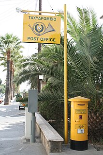
Cyprus Postal Services, or Cyprus Post, is the postal operator of Cyprus and operates the government-operated Post Office. A legacy of British colonial rule is the use of pillar boxes with the initials of the British monarch, although after independence they were painted yellow.
A "postal address" in the Republic of Ireland is a place of delivery defined by Irish Standard (IS) EN 14142-1:2011 and serviced by the universal service provider, An Post. Its addressing guides comply with the guidelines of the Universal Postal Union (UPU), the United Nations-affiliated body responsible for promoting standards in the postal industry, across the world.
The NW postcode area, also known as the London NW postcode area, is a group of 13 postcode districts covering around 13,895 live postcodes within part of northwest London, England. It is the successor of the NW sector, originally created as part of the London postal district in 1856.

Postcodes in Australia are used to more efficiently sort and route mail within the Australian postal system. Postcodes in Australia have four digits and are placed at the end of the Australian address, before the country. Postcodes were introduced in Australia in 1967 by the Postmaster-General's Department and are now managed by Australia Post, Australia's national postal service. Postcodes are published in booklets available from post offices or online from the Australia Post website.
Postal codes in the Cayman Islands are used by the Cayman Islands Postal Service to route inbound mail to groups of post office boxes in the country. A postal code typically consists of an island code, a hyphen separator, and a section code. They were introduced in 2006.
With the exception of mail from Mainland China, postal codes are not used in Hong Kong as the Hongkong Post deems it unnecessary to adopt such system. The People's Republic of China's national postal service, China Post, has allocated postal code 999077 to Hong Kong, although this is only sporadically used when sending mail from Mainland China. As China Post does not serve Hong Kong, this code is generally not used in any other scenarios and remains little-known.
References
- ↑ "A Quick Guide to Using Postcode in Your Mail" (PDF). Montserrat Postal Service.
