
Piscataway is an unincorporated community in Prince George's County, Maryland, United States. It is one of the oldest European-colonized communities in the state. The Piscataway Creek provided sea transportation for export of tobacco. It is located near the prior Piscataway tribe village of Kittamaqundi.

Butler is an unincorporated community in Baltimore County, Maryland, United States. It is bordered to the west by Glyndon, to the east by Sparks, to the south by Cockeysville and to the north by Upperco. It is often referred to as "Worthington Valley". For almost a century, Butler has served as home to many equestrian events, including the Grand Nationals and the Hunt Cup.

Homeland is a neighborhood in the northern part of Baltimore, Maryland, United States. It is bounded roughly by Melrose Avenue on the north, Bellona Avenue on the east, Homeland Avenue on the south, and Charles Street on the west.

John Callahan House, known previously as Pinkney-Callahan House when it was located on St. John Street, is a historic home in Annapolis, Maryland, United States. The brick home was constructed by John Callahan, a prominent and wealthy Annapolitan who served as the Register of the Western Shore Land Office between 1778 and 1803, around 1785–90. It has been moved twice in efforts to prevent its demolition. In 1900–01, the house was relocated to St. John's Street and then to its present site on Conduit Street in 1972. The home features an unusual gable-end principal façade and a largely intact Georgian/Federal interior finishes. It once served as St. John's College Infirmary.
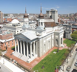
The Cathedral Hill Historic District is an area in Baltimore, Maryland. It lies in the northern part of Downtown just south of Mount Vernon. Roughly bounded by Saratoga Street, Park Avenue, Hamilton Street, and St. Paul Street, these 10 or so blocks contain some of the most significant buildings in Baltimore. The area takes its name from the Basilica of the Assumption which sits in the heart of the district. Despite the number of large religious structures in the area, the district's buildings are primarily commercial in character, with a broad collection of significant commercial structures ranging in date from 1790 to 1940.

St. Ignatius Church is a Catholic church of the Archdiocese of Washington located at 2315 Brinkley Rd., Fort Washington, MD 20744, in Oxon Hill, Prince George's County, Maryland.

The Princess Anne Historic District is located in Princess Anne the county seat of Somerset County, Maryland on Maryland's Eastern Shore. There has been little change due to industry or other development, and the town retains much of its historic character since its founding in the early 18th century. It has been the governmental center since the county was formed in 1742 and the present courthouse is one of the most architecturally distinguished in the state. Within the historic district are a few pre-Revolutionary structures, a high concentration of Federal and Victorian architecture, vernacular dwellings as well as 19th and early-20th century commercial and public buildings. The district contains approximately 270 structures of which nearly 90 percent are contributing to the character of the district.

Cecil's Mill Historic District is a national historic district in Great Mills, St. Mary's County, Maryland. It consists of four buildings: Cecil's Mill, Cecil Store, the Cecil Home, and Old Holy Face Church. Cecil's Mill is a 2+1⁄2-story wood-framed structure, that was used until 1959. Across from the mill is the store, house, and Holy Face Church. The store was constructed in the 1920s and is a good example of a rural store. The Cecil Home was constructed in the late 19th century. Old Holy Face Church is a 2+1⁄2-story frame church that was abandoned in the 1940s.

The Chapel Hill Historic District is a national historic district in Cumberland, Allegany County, Maryland. It is a mixed-use historic district of 810 contributing resources on 145 acres (0.59 km2) located on the southeast side of Cumberland. It contains a mix of residential, commercial, and institutional buildings, with St. Mary's Roman Catholic Church on the highest point. The vast majority of the buildings were built between 1900 and 1910, and includes an extraordinary collection of double houses built for the industrial working class of the city.

Creagerstown is an unincorporated community in Frederick County, Maryland, United States. It is playfully known by its residents as "4 miles from everywhere" because of its situation at 4 miles (6.4 km) from Thurmont, Woodsboro, Rocky Ridge, and Lewistown.

Knoxville is an unincorporated community in Frederick and Washington counties, Maryland, United States. The Robert Clagett Farm and Magnolia Plantation are listed on the National Register of Historic Places.

Lovely Lane United Methodist Church, formerly known as First Methodist Episcopal Church and earlier founded as Lovely Lane Chapel, is a historic United Methodist church located at Baltimore, Maryland, United States.
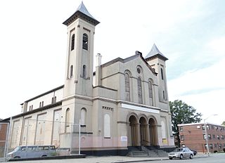
St. John the Evangelist Roman Catholic Church, now known as Sweet Prospect Baptist Church, is a historic Roman Catholic church located at Baltimore, Maryland, United States.

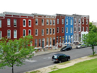
Baltimore East/South Clifton Park Historic District is a national historic district in Baltimore, Maryland, United States. It is primarily an urban residential area organized in a gridiron pattern. It comprises approximately 110 whole and partial blocks that formed the historic northeast corner of the City of Baltimore prior to 1888. While rowhouses dominate the urban area, the historic district also contains other property types which contribute to its character including brewing, meat packing, cigar manufacturing, printing, and a tobacco warehouse. The Baltimore Cemetery completes the historic district.
Old East Baltimore Historic District is a national historic district in Baltimore, Maryland, United States. It is a mainly residential area of Baltimore City that grew up northward from the original mid-18th century settlement east of the Jones Falls, known as Jones Town, or Old Town. It comprises some 70 city blocks covering approximately 194 acres (0.79 km2). The southern part is characterized by vernacular Greek Revival-style working-class housing, constructed in the mid-1840s to mid-1850s for the large numbers of Irish and German immigrants settling there. By the late 1880s and early 1890s all of the blocks in the historic district had been filled with substantial rowhouses showing the influence of Queen Anne and Renaissance Revival styles. The churches in the district include good examples of Italianate, Gothic, Richardsonian Romanesque, Northern European Romanesque, and French Romanesque. Two ethnic Catholic churches, St. John the Evangelist Roman Catholic Church and St. James the Less Roman Catholic Church, are listed separately on the National Register of Historic Places.

Green Spring Valley Historic District is a national historic district near Stevenson in Baltimore County, Maryland, United States. It is a suburban area of Baltimore that acquires significance from the collection of 18th, 19th, and early 20th century buildings. The park-like setting retains a late 19th-early 20th century atmosphere. At the turn of the 20th century, the Maryland Hunt Cup and the Grand National Maryland steeplechase races were run over various parts of the valley. The Maryland Hunt Cup, which began as a competition between the Green Spring Valley Hunt and the Elkridge Hunt, traditionally started at Brooklandwood, the previous home of Charles Carrol of Carrollton with the finish across Valley Road at Oakdene, at that time the home of Thomas Deford, which remains a private residence

The Easton Historic District is a historic district that covers most of the core of the town of Easton, Maryland. The town is the county seat of Talbot County. The state of Maryland is nearly split by the Chesapeake Bay, and Easton is located on the east side of the bay that is known as Maryland's Eastern Shore. Although the town is part of the east coast of the United States, the region's history goes back to a time when Maryland was a colonial province of England.

Maryland Route 550 is a state highway in the U.S. state of Maryland. The state highway runs 24.43 miles (39.32 km) from MD 26 in Libertytown north to Pen Mar Road in Fort Ritchie. MD 550 runs southeast–northwest across central Frederick County, connecting Fort Ritchie in the northeastern corner of Washington County and Libertytown with the towns of Thurmont and Woodsboro and the smaller communities of Creagerstown and Sabillasville. South of the highway's junction with U.S. Route 15 in Thurmont, the state highway passes through the wide valley of the Monocacy River; to the north, the highway passes along the northern edge of Catoctin Mountain and crests South Mountain near Blue Ridge Summit, Pennsylvania.

East Monument Historic District or Little Bohemia, is a national historic district in Baltimore, Maryland. It is a large residential area with a commercial strip along East Monument Street. It comprises approximately 88 whole and partial blocks. The residential area is composed primarily of rowhouses that were developed, beginning in the 1870s, as housing for Baltimore's growing Bohemian (Czech) immigrant community. During the late 19th and early 20th centuries the neighborhood was the heart of the Bohemian community in Baltimore. The Bohemian National Parish of the Roman Catholic Church, St. Wenceslaus, is located in the neighborhood. The historic district includes all of McElderry Park and Milton-Montford, most of Middle East and Madison-Eastend, and parts of Ellwood Park.

Hollins–Roundhouse Historic District is a national historic district in Baltimore, Maryland, United States. It is a primarily residential area characterized by 19th century rowhouses. The neighborhood is historically significant due to its association with the development of rail transportation in Maryland. Additional historical significance comes from the neighborhood's association with ethnic immigration to Baltimore. During the 1840s and 1850s the area was a center of settlement for Baltimore's German and Irish communities, many of whom immigrated to the United States to work in the rail industry. Later, from the 1880s to the 1920s, the neighborhood became established as the center of Baltimore's Lithuanian immigrant community. Because of the large Lithuanian population in the area north of Hollins Street, the area became known as Little Lithuania. A few remnants of the neighborhood's Lithuanian heritage still remain, such as Lithuanian Hall located on Hollins Street.


