St. John's metropolitan area

Last updated

St. John's metropolitan area
City of St. John's.jpg
St. John's metropolitan area
Interactive Map of St. John's, NL CMA
Coordinates: 47°34′3″N52°42′26″W / 47.56750°N 52.70722°W / 47.56750; -52.70722
Country Flag of Canada (Pantone).svg  Canada
Province Flag of Newfoundland and Labrador.svg  Newfoundland and Labrador
Census division Division 1
Largest city St. John's
Other towns and cities- Conception Bay South
- Paradise
- Mount Pearl
Government
   MPs
   MHAs
Area
  Metro
931.56 km2 (359.68 sq mi)
Population
 (2021 [1] )
   Metro
212,579
  Metro density228.2/km2 (591/sq mi)
  20th Largest metropolitan area in Canada
Gross Metropolitan Product
  St. John's CMA CA$12.9 billion (2020) [2]
Time zone UTC-3:30 (NST)
  Summer (DST) UTC-2:30 (NDT)
Area code 709

The St. John's metropolitan area is the most populous census metropolitan area (CMA) in the Canadian province of Newfoundland and Labrador. With a population of 212,579 in the 2021 Canadian Census, [1] the CMA is the second largest in Atlantic Canada and the 22nd largest CMA in Canada. [3]

Contents

The St. John’s CMA has an estimated population of 212,579 as of 2021. [4] The CMA comprises the City of St. John's and twelve other communities, the largest of which are the town of Conception Bay South and the city of Mount Pearl. [5]

Demographics

The following information is from: Statistics Canada [5] [6] [7]

Population

Historical population
YearPop.±%
1986 164,593    
1991 175,391+6.6%
1996 174,051−0.8%
2001 172,918−0.7%
2006 181,113+4.7%
2011 196,966+8.8%
2016 208,418+5.8%
2021 212,579+2.0%

Municipalities

MunicipalityType20012006201120162021 [8]
St. John's City99,182100,646106,172108,860110,525
Conception Bay South Town19,77221,96624,84826,19927,168
Paradise Town9,59812,58417,69521,38922,975
Mount Pearl City24,96424,67124,28422,95722,447
Portugal Cove – St. Philip's Town5,8666,5757,3668,1478,415
Torbay Town5,4746,2817,3977,8997,852
Holyrood [9] Town1,9062,0051,9952,4632,471
Logy Bay – Middle Cove – Outer Cove Town1,8721,9782,0982,2212,364
Pouch Cove Town1,6691,7561,8662,0692,063
Flatrock Town1,1381,2141,4571,6831,722
Witless Bay Town1,0561,0701,1791,6191,640
Bay Bulls Town1,0141,0781,2831,5001,566
Petty Harbour – Maddox Cove Town949915924960947
Bauline Town364379397452412

Population density

RankMunicipalityPopulationLand AreaPopulation Density
km2mi2/km2/mi2
-St. John's metropolitan area205,955804.65310.68244.8634
1 St. John's 108,860446.04172.22238.0616
2 Conception Bay South 26,19959.2722.88419.21,086
3 Mount Pearl 22,95715.756.081,542.13,994
4 Paradise 21,38929.2411.29605.21,567
5 Portugal Cove – St. Philip's 8,14757.3522.14128.4333
6 Torbay 7,89934.8813.47212.1549
7 Logy Bay – Middle Cove – Outer Cove 2,22116.986.56123.6320
8 Pouch Cove 2,06958.3422.5332.083
9 Flatrock 1,68318.127.0080.4208
10 Witless Bay 1,61918.497.1467.4175
11 Bay Bulls 1,50030.7411.8741.7108
12 Petty Harbour – Maddox Cove 9604.511.74205.1531
13 Bauline 45215.956.1624.964

Related Research Articles

<span class="mw-page-title-main">Labrador</span> Mainland portion of Newfoundland and Labrador

Labrador is a geographic and cultural region within the Canadian province of Newfoundland and Labrador. It is the primarily continental portion of the province and constitutes 71% of the province's area but is home to only 6% of its population. It is separated from the island of Newfoundland by the Strait of Belle Isle. It is the largest and northernmost geographical region in the four Atlantic provinces.

<span class="mw-page-title-main">St. John's, Newfoundland and Labrador</span> Capital and largest city of Newfoundland and Labrador, Canada

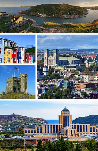
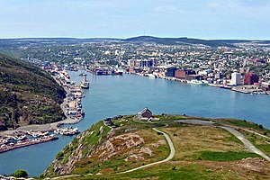
St. John's is the capital and largest city of the Canadian province of Newfoundland and Labrador. It is located on the eastern tip of the Avalon Peninsula on the island of Newfoundland. The city spans 446.04 km2 (172.22 sq mi) and is the easternmost city in North America.

<span class="mw-page-title-main">Central Canada</span> Region of Eastern Canada

Central Canada is a Canadian region consisting of Ontario and Quebec, the largest and most populous provinces of the country. Geographically, they are not at the centre of Canada but instead overlap with Eastern Canada toward the east. Because of their large populations, Ontario and Quebec have traditionally held a significant amount of political power in Canada, leading to some amount of resentment from other regions of the country. Before Confederation, the term "Canada" specifically referred to Central Canada. Today, the term "Central Canada" is less often used than the names of the individual provinces.

<span class="mw-page-title-main">Paradise, Newfoundland and Labrador</span> Town in Newfoundland, Canada

Paradise is a town on the Avalon Peninsula in the province of Newfoundland and Labrador, Canada. Paradise is the third largest settlement in the province and is part of the St. John's metropolitan area, the 20th largest metropolitan area in Canada. The town borders the City of St. John's, the City of Mount Pearl, the Town of Portugal Cove-St. Philip's, and the town of Conception Bay South.

<span class="mw-page-title-main">Holyrood, Newfoundland and Labrador</span> Town in Newfoundland and Labrador, Canada

Holyrood is a town on the Avalon Peninsula in Newfoundland and Labrador, Canada. It is in Division 1, on Conception Bay. It is approximately a 30-minute drive from the capital city of St. John's. During King William's War, the village was destroyed in the Avalon Peninsula Campaign.

<span class="mw-page-title-main">Census geographic units of Canada</span> Term used in Canada

The census geographic units of Canada are the census subdivisions defined and used by Canada's federal government statistics bureau Statistics Canada to conduct the country's quinquennial census. These areas exist solely for the purposes of statistical analysis and presentation; they have no government of their own. They exist on four levels: the top-level (first-level) divisions are Canada's provinces and territories; these are divided into second-level census divisions, which in turn are divided into third-level census subdivisions and fourth-level dissemination areas.

<span class="mw-page-title-main">Calgary Metropolitan Region</span> Metropolitan area in Alberta, Canada

The Calgary Metropolitan Region (CMR), also commonly referred to as the Calgary Region, is a conglomeration of municipalities centred on Calgary, the largest city in Alberta.

<span class="mw-page-title-main">Marystown</span> Town in Newfoundland and Labrador, Canada

Marystown is a town in the province of Newfoundland and Labrador, Canada, with a population of around 5,000. Situated 306 km from the province's capital, St. John's, it is on the Burin Peninsula. Until the early 1990s, its economy was largely based on shipbuilding, and it is due in part to this that the town experienced a population increase of 295% in just over a decade. The town was also dependent on the fish plant for employment.

<span class="mw-page-title-main">Winnipeg Metropolitan Region</span> Metropolitan area in Manitoba, Canada

The Winnipeg Metropolitan Region is a metropolitan area in the Canadian province of Manitoba located in the Red River Valley in the southeast portion of the province of Manitoba, Canada. It contains the provincial capital of Winnipeg and 17 surrounding rural municipalities, cities, and towns.

<span class="mw-page-title-main">Torbay, Newfoundland and Labrador</span> Town in Newfoundland and Labrador, Canada

Torbay is a town located on the eastern side of the Avalon Peninsula in Newfoundland and Labrador, Canada.

<span class="mw-page-title-main">Edmonton Metropolitan Region</span> Metropolitan area in Canada, Alberta

The Edmonton Metropolitan Region (EMR), also commonly referred to as Greater Edmonton or Metro Edmonton, is a conglomeration of municipalities centred on Edmonton, the capital of the Canadian province of Alberta.

<span class="mw-page-title-main">Demographics of Ontario</span>

Ontario, one of the 13 provinces and territories of Canada, is located in east-central Canada. It is Canada's most populous province by a large margin, accounting for nearly 40 percent of all Canadians, and is the second-largest province in total area. Ontario is fourth-largest in total area when the territories of the Northwest Territories and Nunavut are included. It is home to the nation's capital city, Ottawa, and the nation's most populous city, Toronto.

<span class="mw-page-title-main">Demographics of Newfoundland and Labrador</span>

Newfoundland and Labrador is a province of Canada on the country's Atlantic coast in northeastern North America. The province has an area of 405,212 square kilometres and a population in 2024 of 540,552, with approximately 95% of the provincial population residing on the Island of Newfoundland, with more than half of the population residing on the Avalon Peninsula. People from Newfoundland and Labrador are called "Newfoundlanders," "Labradorians", or "Newfoundlanders and Labradorians".

<span class="mw-page-title-main">Mount Pearl</span> City in Newfoundland and Labrador, Canada

Mount Pearl is the fourth-largest settlement and second-largest city in Newfoundland and Labrador, Canada. The city is located southwest of St. John's, on the eastern tip of the Avalon Peninsula on the island of Newfoundland. Mount Pearl is the fourth largest settlement in the province and is part of the St. John's metropolitan area, the 20th largest metropolitan area in Canada.

<span class="mw-page-title-main">Saskatoon metropolitan area</span> Census Metropolitan Area in Saskatchewan, Canada

The Saskatoon region is the greater metropolitan area of Saskatoon, Saskatchewan. As of 2021 the Statistics Canada estimates the region's population to be 317,480 people.

<span class="mw-page-title-main">Demographics of Calgary</span>

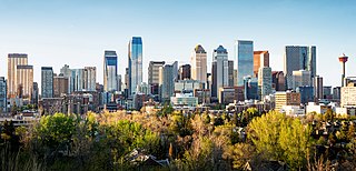
In the 2021 Census, the City of Calgary had a population of 1,306,784 residents, representing 30.7% of the 4,262,635 residents in all of Alberta, and 3.5% compared to a population of 36,991,981 in all of Canada. The total population of the Calgary census metropolitan area (CMA) was 1,481,806. Calgary is the largest city in Alberta, and the third-largest municipality and fifth-largest metropolitan area in Canada, as of 2021.

References

  1. 1 2 "Census Profile, 2021 Census: St. John's [Census metropolitan area], Newfoundland and Labrador".
  2. "Statistics Canada. Table 36-10-0468-01 Gross domestic product (GDP) at basic prices, by census metropolitan area (CMA) (x 1,000,000)". Statistics Canada.
  3. The City of St. John's — City Information Archived 2009-02-22 at the Wayback Machine
  4. "Table 4 Population estimates by census metropolitan area". Statistics Canada. 27 March 2018. Retrieved 2018-08-22.
  5. 1 2 "Population and dwelling counts, for Canada, census metropolitan areas, census agglomerations and census subdivisions (municipalities), 2011 and 2006 censuses". Statistics Canada. Retrieved 9 February 2012.
  6. "Census Profile, 2016 Census: St. John's [Census metropolitan area], Newfoundland and Labrador". Statistics Canada. Retrieved April 7, 2020.
  7. Government of Canada, Statistics Canada (2022-02-09). "Data table, Census Profile, 2021 Census of Population - St. John's [Census metropolitan area], Newfoundland and Labrador". www12.statcan.gc.ca. Retrieved 2022-03-02.
  8. "Census Profile, 2021 Census of Population". 9 February 2022.
  9. "Census geography: Maps". 17 November 2021.