St. Margarets Bay, Nova Scotia

Last updated
St. Margarets Bay as seen from Indian Harbour Indian Harbour NS.JPG
St. Margarets Bay as seen from Indian Harbour
Map of St. Margarets Bay Map highlighting St. Margarets Bay, Nova Scotia.png
Map of St. Margarets Bay

St. Margarets Bay is a bay located on the Atlantic coast of Nova Scotia, Canada on the border of Halifax County (Halifax Regional Municipality) and Lunenburg County (Municipality of the District of Chester).

Bay A recessed, coastal body of water connected to an ocean or lake

A bay is a recessed, coastal body of water that directly connects to a larger main body of water, such as an ocean, a lake, or another bay. A large bay is usually called a gulf, sea, sound, or bight. A cove is a type of smaller bay with a circular inlet and narrow entrance. A fjord is a particularly steep bay shaped by glacial activity.

Atlantic Ocean Ocean between Europe, Africa and the Americas

The Atlantic Ocean is the second largest of the world's oceans, with an area of about 106,460,000 square kilometers. It covers approximately 20 percent of the Earth's surface and about 29 percent of its water surface area. It separates the "Old World" from the "New World".

Nova Scotia Province of Canada

Nova Scotia is one of Canada's three Maritime Provinces, and one of the four provinces that form Atlantic Canada. Its provincial capital is Halifax. Nova Scotia is the second-smallest of Canada's ten provinces, with an area of 55,284 square kilometres (21,300 sq mi), including Cape Breton and another 3,800 coastal islands. As of 2016, the population was 923,598. Nova Scotia is Canada's second-most-densely populated province, after Prince Edward Island, with 17.4 inhabitants per square kilometre (45/sq mi).

Contents

Description

Opening south directly onto the Atlantic, the bay's eastern shore is formed by the Chebucto Peninsula and its western shore by the Aspotogan Peninsula, while the head of the bay (the northern shore) is the main part of the Nova Scotia peninsula.

Chebucto Peninsula

The Chebucto Peninsula is a Canadian peninsula located in central Nova Scotia entirely within the Halifax Regional Municipality on the Atlantic coast.

Aspotogan Peninsula peninsula

The Aspotogan Peninsula is a peninsula in the eastern part of Lunenburg County, Nova Scotia, separating St. Margarets Bay in the east from Mahone Bay in the west. The peninsula was originally settled by second generation French immigrants on the east side and by second generation German immigrants on the west side. Traditionally fishing was a major industry for communities throughout the peninsula, however other primary industries such as farming and forestry were historically important as well. Shipping and shipbuilding were secondary and tertiary industries that also came into prominence during the 19th and early 20th centuries.

The Nova Scotia peninsula is a peninsula on the Atlantic coast of North America.

The bay's shoreline is mostly rocky, although the head of the bay offers several sandy beaches at Queensland, Black Point and Cleveland; another sandy beach exists on the western shore of the bay at Bayswater and there is a small sandy beach along the eastern shore on Micou's Island. St. Margarets Bay is a cruising destination for sailing yachts as its picturesque shorelines offer protection in many natural harbours, as well as anchorages in coves and near small islands.

Micou's Island is a 22-acre (89,000 m2) tidal island located in the Glen Haven community near the eastern shore of St. Margarets Bay, Nova Scotia, Canada. The island is accessible by a sandbar at low tide and has become a popular beach during summer months.

Cruising (maritime) lifestyle that involves living for extended time on a boat while traveling from place to place for pleasure

Cruising by boat is a lifestyle that involves living for extended time on a vessel while traveling from place to place for pleasure. Cruising generally refers to trips of a few days or more, and can extend to round-the-world voyages.

Communities

Eastern Shore

Along the Chebucto Peninsula (from south to north):

Indian Harbour, Nova Scotia

Indian Harbour is a small fishing community of the Halifax Regional Municipality in the Canadian province of Nova Scotia on the Chebucto Peninsula. It is located between the communities of Peggy's Cove and Hackett's Cove.

Seabright, Nova Scotia Community in Nova Scotia, Canada

Seabright is a community within the Halifax Regional Municipality Nova Scotia between French Village and Glen Margaret on Route 333 along the Lighthouse Route. It was home to the noted Canadian curator and historian Niels Jannasch (1924-2001).

Glen Haven, Nova Scotia Rural Community in Nova Scotia, Canada

Glen Haven is a small coastal community within the Halifax Regional Municipality of Nova Scotia, Canada, about 40 km from Halifax city centre. It is situated on the shore of the St. Margarets Bay immediately adjacent to Tantallon and French Village along Route 333, also known as Peggy's Cove Road.

Northern Shore

Along the head of the bay (from east to west):

Head of St. Margarets Bay, Nova Scotia Rural Community in Nova Scotia, Canada

Head of St. Margarets Bay is a rural community on the northeast corner of St. Margarets Bay. The community is in the Halifax Regional Municipality, 40 km west from Halifax via on Trunk 3.

Boutiliers Point, Nova Scotia Community in Nova Scotia, Canada

Boutiliers Point is a rural community in the Halifax Regional Municipality on the shore of the Atlantic Ocean on Trunk 3, 27.61 kilometers from Halifax.

Hubbards, Nova Scotia Rural Community in Nova Scotia, Canada

Hubbards is an unincorporated Canadian rural community on the South Shore of Nova Scotia.

Western Shore

Along the Aspotogan Peninsula (from north to south):

Islands

St. Margarets Bay contains numerous islands, particularly along its eastern shore. These islands were historically used by the Mi'kmaq Nation and some contain burial sites.

The bay's larger islands are listed below:

Swissair 111

Swissair 111 Memorial, Peggys Cove, Nova Scotia Peggys Cove Swissair Flight 111.jpg
Swissair 111 Memorial, Peggys Cove, Nova Scotia

The Swissair Flight 111 Memorial is located at The Whalesback, a promontory approximately 1 km northwest of Peggys Cove. It is one of two memorials built to commemorate the victims of the Swissair Flight 111 disaster, which crashed into St. Margarets Bay on 2 September 1998. The crash site is roughly equidistant between the Whalesback Memorial and another memorial at Bayswater, Nova Scotia, located on the Aspotogan Peninsula on the western shore of the bay, opposite Peggys Cove.

The monument reads in English and French: "In memory of the 229 men, women and children aboard Swissair Flight 111 who perished off these shores September 2nd, 1998. They have been joined to the sea, and the sky. May they rest in peace."

The site of the crash and the two monuments form a triangle. The three notches on the monument at Whalesback represent the numerals 111. The sight line from the three grooves in the stone points to the crash site, while the markings on the facing stone point to the memorial at Bayswater. The memorial wall at Bayswater lists the names of the passengers and crew. The facing stone points to the crash site.

War Plan Red

In the period between World War I and World War II the US military drew up a series of Colour Coded War Plans based on likely global threats. War Plan Red denoted a planned attack against the British Empire and by extension War Plan Crimson which called for an invasion of Canada. The plan involved an attack on many fronts starting with a seabourne invasion of Halifax and Canada's Maritime provinces via St. Margarets Bay.

Related Research Articles

Swissair Flight 111 Aviation accident in 1998

Swissair Flight 111 was a scheduled international passenger flight from John F. Kennedy International Airport in New York City, United States to Cointrin International Airport in Geneva, Switzerland. This flight was also a codeshare flight with Delta Air Lines. On 2 September 1998, the McDonnell Douglas MD-11 performing this flight, registration HB-IWF, crashed into the Atlantic Ocean southwest of Halifax International Airport at the entrance to St. Margarets Bay, Nova Scotia. The crash site was 8 kilometres (5 mi) from shore, roughly equidistant from the tiny fishing and tourist communities of Peggy's Cove and Bayswater. All 229 passengers and crew onboard the MD-11 were killed, making the crash the deadliest McDonnell Douglas MD-11 accident in aviation history.

Peggys Cove, Nova Scotia Community in Nova Scotia, Canada

Peggy's Cove is a small rural community located on the eastern shore of St. Margarets Bay in Nova Scotia's Halifax Regional Municipality, which is the site of Peggys Point Lighthouse.

Halifax Peninsula Community in Nova Scotia, Canada

The Halifax Peninsula is a community and planning area located in the urban core of municipal Halifax, Nova Scotia. Halifax Peninsula is home to Downtown Halifax, the financial and economic heart of the municipality, which was also the site of the original settlement and town of Halifax. The town of Halifax was founded by the British government under the direction of the Board of Trade and Plantations under the command of Governor Edward Cornwallis in 1749. Geographically, the Halifax Peninsula is a Canadian peninsula in central Nova Scotia.

Chester-St. Margarets

Chester—St. Margaret's is a provincial electoral district in Nova Scotia, Canada, that elects one member of the Nova Scotia House of Assembly. It is located on the South Shore.

Nova Scotia Trunk 3 is an east-west trunk highway in Nova Scotia. The route runs from Halifax to Yarmouth, along the South Shore. Trunk 3's status as an important regional highway link has been superseded by the parallel Highway 103.

Nova Scotia Route 333 highway in Nova Scotia

Route 333 is a collector road in the Canadian province of Nova Scotia.

Lighthouse Route

The Lighthouse Route is a scenic roadway in the Canadian province of Nova Scotia. It follows the province's South Shore for 339 km (211 mi) from Halifax to Yarmouth.

Route 329 is a collector road in the Canadian province of Nova Scotia.

Terence Bay, Nova Scotia

Terence Bay is a rural fishing community on the Chebucto Peninsula in the Halifax Regional Municipality, Nova Scotia. It is located on the shore of the Atlantic Ocean, 10 km off the Prospect Road, off Route 333, 21.2 kilometers from Halifax.

Canadian Forces Station Mill Cove is a former Canadian Forces Station and currently a naval radio station located near Hubbards, Nova Scotia. Built in 1967, it is remotely operated by the Canadian Forces from CFB Halifax.

CCGS <i>Sambro</i>

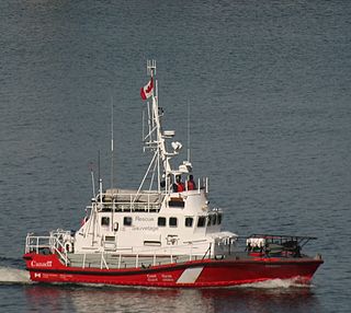
CCGS Sambro is a Canadian Coast Guard search and rescue ship homeported in Sambro, Nova Scotia.

Bayswater, Nova Scotia human settlement in Canada

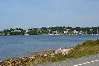
Bayswater is a community in the Canadian province of Nova Scotia, located in the Chester Municipal District on the Aspotogan Peninsula on the Lighthouse Route.

Mill Cove, Nova Scotia human settlement in Canada

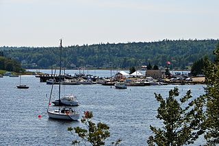
Mill Cove is a community in the Canadian province of Nova Scotia, located in the Chester Municipal District on the Aspotogan Peninsula on the Lighthouse Route. The community was home to CFS Mill Cove from 1967 til the 1990s.

References

    Nautical chart #4386 St. Margarets Bay, published by Canadian Hydrographic Service, 2004 Coordinates: 44°35′N64°00′W / 44.583°N 64.000°W / 44.583; -64.000 (St. Margarets Bay)